Swell slowly clocks more east with south winds

Eastern Tasmanian Surf Forecast by Craig Brokensha (issued Friday December 16th)
Best Days: Southern corners Saturday, Sunday, Monday morning and Tuesday morning
Features of the Forecast (tl;dr)
- Moderate sized SE swell Sat, with a better pulse Sun, then E/SE pulse Mon AM
- Fresh S/SW tending strong S/SE winds tomorrow, mod-fresh S/SW tending fresh S/SE Sun
- Light-mod SW tending SE winds Mon, light-mod S/SW-SW tending SE winds Tue
Recap
Windy, localised south swell through yesterday, similar today though with a touch more east in the direction, allowing more size to get into southern corners.
This weekend and next week (Dec 17 - 23)
The strong, broad Tasman Low linked to our current windy south conditions is now a little further east, and this is allowing our coast to be more open to SE swell energy.
Strong SE winds on the southern flank of the low should produce plenty of size into the weekend and early next week but winds will remain a problem.
A fresh and gusty S/SW wind is due early tomorrow, shifting S/SE and strengthening into the afternoon.
Size wise, the SE energy looks to come in around the 4ft range across northern ends tomorrow, with a better pulse of mid-period energy for Sunday back to 3-5ft. Winds on Sunday will play out similar in direction to Saturday but with less strength into the afternoon. Either way southern corners will still be the best.
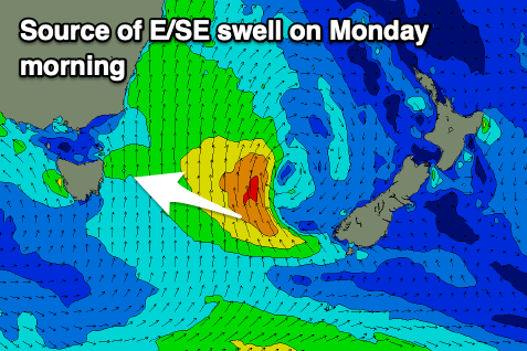
Lighter SW winds are due on Monday morning (SE afternoon) and we're looking at one final pulse of E/SE energy, generated by the low strengthening again just west of New Zealand's South Island. This will project strong SE winds on top an active sea state towards us, keeping 3-5ft sets hitting open beaches Monday morning, easing into the afternoon and then down slowly from 3ft Tuesday.
Tuesday morning should be favourable again with a S/SW-SW breeze, shifting SE into the afternoon. From Wednesday we'll see winds shift back to the N/NE along with small levels of NE windswell. More on this Monday. Have a great weekend!