Prolonged south-southeast swell

Eastern Tasmanian Surf Forecast by Craig Brokensha (issued Wednesday December 14th)
Best Days: Southern corners Friday, Saturday, Sunday, Monday morning
Features of the Forecast (tl;dr)
- Moderate sized + S-S/SE swell for tomorrow and Fri
- Moderate sized SE swell Sat, with a better pulse Sun, easing Mon
- Strong S winds Thu and strong S tending S/SE Fri, Sat, Sun
- Strong S/SW tending S/SE winds
- Lighter SW tending SE winds Mon, S/SE Tue
Recap
A small NE windswell held in at 1-2ft across the magnets yesterday morning with clean conditions, similar this morning, while this afternoon winds are strengthening owing to a trough moving offshore. This is also whipping up a S'ly windswell.
This week and next (Dec 15 - 23)
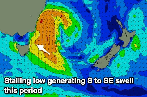
Today's strengthening S'ly winds will kick up some mid-period S'ly swell this afternoon, and we'll see the trough linked to the current blow deepening into a low pressure system directly north-east of us overnight.
As this happens, we'll see stronger S/SE winds generated east of us, but it looks like the axis will sit a little too far north to generate any major power or size to the swell.
Instead, we'll see moderate + levels of mid-period S-S/SE swell over the coming days, swinging more SE in direction on the weekend as the low starts pushing east. This will open our swell window to the southern flank of the low and S/SE winds wrapping around it.
The slow movement of the low will see the swell become quite prolonged in nature, with fun surf due into Tuesday next week.
Looking at tomorrow and the swell will still be quite south in nature and 4-5ft+ across northern ends, much smaller in southern corners and with strong S winds, less than ideal.
The swell should swing a touch more S/SE on Friday along with strong S tending S/SE winds. 4-5ft+ sets are due across northern ends again with a touch more energy sneaking into southern corners.
Come the weekend, better SE swell should come in around 4ft on Saturday, with a good pulse to 3-5ft Sunday, easing back slowly Monday from 3-4ft.
Winds will remain an issue and strong from the S/SW tending S/SE both Saturday and Sunday, so stick to southern corners. Monday looks to finally offer a better SW breeze in the morning (check back Friday) along with the easing SE swell energy.
Another trough may bring unfavourable S/SE winds on Tuesday but we'll have a closer look at this Friday.
Longer term we may see some fun NE windswell later in the week, but we've got a bit to get through before then.