Volcom Fiji Pro surf forecasts

We've got an interesting forecast period ahead. Key points are:
* No overly significant swell events within the waiting period (ie 8-10ft+)
* Windy conditions over the next few days (pre-event) will ease rapidly by Sunday
* Lay days likely Sun/Mon/Tues due to small swells
* Moderate but very inconsistent swells expected Wed/Thurs/Fri (best/biggest day Friday at this stage)
* Long term: Another moderate+ swell building next Saturday afternoon, peaking early Sunday morning (5-6ft)
* Super long term: downwards trend early in the following week, with a chance for another moderate+ swell (5-6ft) in or around the last day of the waiting period
*please note - we are using 'surfers feet' scale for estimated wave heights, which is: head high = 3ft, overhead = 4ft, several feet overhead = 5ft, double overhead = 6ft, etc*
Cloudbreak 5+ day surf forecast
Forecast prepared by Ben Matson and Craig Brokensha, issued Thursday 30th May
Fri: Easing surf from 6-8ft to 4-5ft. Gusty E/SE winds tending fresh E/NE during the day.
Sat: Easing surf from 3-5ft to 2-3ft. Moderate to fresh NE to NW winds at times.
Sun: Mix of fading SW groundswell and short range SE swell around 3ft. Moderate to fresh SE winds redeveloping and easing later.
Mon: Slow, inconsistent mix of swells around 2-3ft with light E/SE winds.
Tues: Slow, inconsistent mix of swells around 2-3ft with light E/SE winds. Possible late pulse of new swell.
Longer term: Moderate swells building Wed/Thurs, peaking early Friday
Explanatory notes
A large but wind affected S/SW groundswell is currently peaking across the Fijian coast, with size estimated to be in the 10ft range (although we have received no confirmation of this yet). Satellite winds are recording a broad area of 30kts winds across Fijian waters which is probably adding a reasonable short range SE swell into the mix, as well as making for blustery surf conditions.
Today's swell event will ease steadily from Friday onwards, and winds will swing northerly early Saturday as a small, intense tropical low develops within a broad trough to the south-west of Fiji. Winds will then veer back to the southeast overnight Saturday as the trough tracks away from the region, with wind speeds steadily abating through Sunday.
The tropical low will contribute a modest mid-range swell to the region on Sunday however these swells are usually not favourable for Cloudbreak (due to the direction and low swell period). However the combination of this swell and residual SW energy from today's event should maintain peaky 3ft waves at Cloudbreak with light to moderate SE winds. A similarly small mix of swells (including some new distant energy) should maintain clean 2-3ft waves at Cloudbreak on Monday with light E/SE winds. No major improvement is expected on Tuesday although another distant long period swell may provide very inconsistent 2-3ft waves at times. A new swell is due on Wednesday but we may see a few sets appear on Tuesday in the few hours before dark.
Wednesday looks to offer the first day of competition waves, with a new SW groundswell generated by a small but deep polar low that is developing off the ice shelf today, directly south of Tasmania. Although the low looks impressive on paper, it is positioned a very long distance from Fiji and will unfortunately last for just a very short time within our swell window. As such, set waves will be extremely inconsistent but we should see occasional 3-4ft waves at Cloudbreak.
As for conditions on Wednesday, a building ridge should freshen the SE airstream about the region during this time which should ensure generally clean conditions at Cloudbreak.
From here on we're expecting a small increase in size through Thursday, and Friday, originating from a series of Southern Ocean lows and fronts that will track up into waters just below the Tasman Sea. Unfortunately, recent model updates have suggested that a broad area of high pressure across the Tasman will suppress the extent of their northern track, which will limit eventual surf size in Fiji and also reduce consistency. However we are looking at good (albeit inconsistent) 3-5ft waves on Thursday with moderate to occasionally fresh SE winds, building further to 4-6ft on Friday with similar winds. Again, expect very long breaks between set waves.
Looking further ahead, and we've got a few sources of swell on the cards for the rest of the waiting period - but nothing of any great size right now. Another moderate+ swell may kick in on Saturday afternoon (peaking Sunday) originating from the tail end of the frontal stream responsible for the Thurs/Fri swells, however it will again be very inconsistent.
A broad blocking pattern is modelled to develop across our primary swell window mid-late next week, which will then result in a couple of days of smaller conditions during the early to middle part of the following week.
However, a much more significant series of weather systems are likely to move into Fiji's swell window sometime around next weekend, and there is a suggestion that we'll see a potentially strong swell arriving in or around the last day of the waiting period. However this is still a very long time away and will require further evaluation over the coming days.
I've had a few network issues over the last few days that's prevented me from updating. Here's the latest forecast issued Sunday evening.
Volcom Fiji Pro Surf Forecast
Notes prepared by Ben Matson
Next Forecast: Monday 3rd June 6pm AEST
Key Points
*Mainly small surf expected to continue Monday/Tuesday
*Moderate but very inconsistent SW groundswell expected Wednesday
*Large surf Thurs/Fri with generally good winds
*please note - we are using 'surfers feet' scale for estimated wave heights, which is: head high = 3ft, overhead = 4ft, several feet overhead = 5ft, double overhead = 6ft, etc*
Cloudbreak 5+ day surf forecast
Mon: Slow, inconsistent mix of swells around 2-3ft+ with light to moderate SW winds tending variable. Size easing during the day.
Tues: Slow, inconsistent mix of swells around 2-3ft with light variable winds. New long range SW groundswell starting to show in the afternoon with occasional 3-4ft sets possible late.
Wed: Inconsistent SW groundswell around 3-4ft with light variable winds for much of the day, may tend S'ly late a'noon. The leading edge of a new W/SW swell may appear in the few hours before dusk with stray 4-6ft sets.
Thurs: Solid W/SW tending SW swell with set waves around 6-8ft+ early morning, easing a little during the day. Moderate to fresh SE winds developing during the day (lighter early).
Fri: Secondary pulse of SW swell around 6-8ft+ early, easing during the day. Moderate to fresh SE winds developing during the day (lighter early).
Longer term: Easing surf Saturday with similar winds. Renewal of moderate groundswell Sun, but easing steadily Mon thru' Wed. Chance for a pulse of inconsistent long range groundswell on the last day of the waiting period.
Explanatory notes
Unfavourable SW winds delivered poor conditions at Cloudbreak for the first day of the waiting period. These winds were the result of a broad, deep trough of low pressure to the south of the region, which is presently slipping away to the south-east. No swell of any significance is expected from this source (SE swells are generally poor performers at Cloudbreak, and this system is not favourably aligned towards Fiji either).
Monday and Tuesday are not expected to see any significant surf across the Fijian region. Conditions will slowly improve as winds become light and variable however there are no new notable swells expected during this time, just some distant background energy that may generate occasional 2-3ft waves at Cloudbreak.
The outlook for our anticipated swells from Wednesday onwards has changed considerably since Thursday's forecast. The reason for this is due to significant divergence between computer model output, mainly regarding a low pressure system developing in the Tasman Sea at the present time.
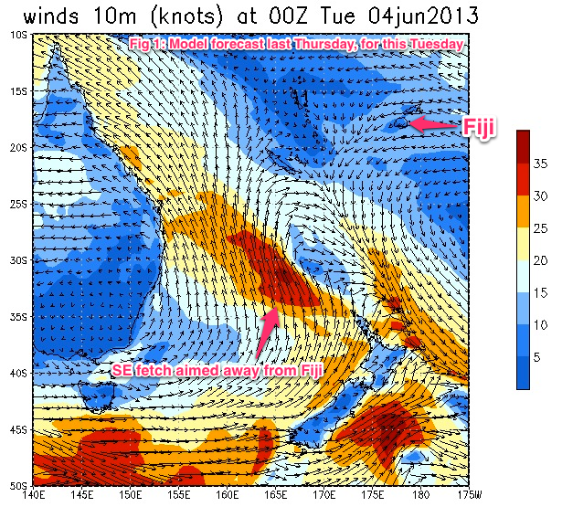
On Thursday, computer models anticipated that this low would be strongly influenced by a broad ridge of high pressure over much of eastern Australia. This was expected to focus the associated fetch up into the Coral Sea, exhibiting mainly S/SE winds – aimed well and truly away from Fiji.
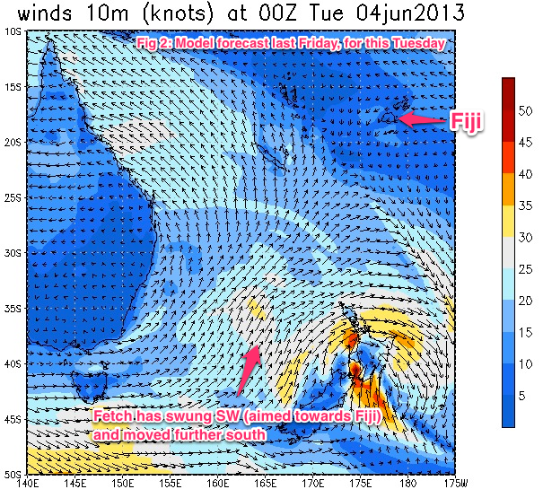
During subsequent updates, the computer models broke down their expectations of this ridge and allowed the possibility that it may merge with approaching frontal systems from the far Southern Ocean. Although there have been many upgrades and downgrades since Thursday, this new theme has been consistent across the board so we can have a reasonable level of confidence that it will eventuate.
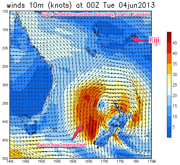
What this means is that we're looking at a complex pulse of additional mid-range SW swell on Thursday and Friday (on top of a smaller, already-anticipated groundswell). This should boost wave heights at Cloudbreak into the 6-8ft+ range.
Also worth keeping an eye out on Wednesday will be the forerunners of this swell event, generated by a rapid intensification of the low in the central Tasman Sea on Monday. As it is, we're already expecting a small to moderate long period groundswell to be in the water on Wednesday (generated by a polar low over the weekend) however new energy from the Tasman Low – with a noticeable W/SW bias in its direction - may start to appear during the last few hours of the day. It's unlikely to arrive early enough to be beneficial for the competition, however I wouldn't be surprised if we saw some late bomb sets in in the 4-6ft range. Light winds are expected for much of the day ahead of a late southerly tendency as a weak trough clears to the east and a high ridges in from the west.
Thursday looks very good across the board. We're actually expecting two pulse of swell from this Tasman Low, the first will peak early Thursday morning and trend slowly downwards during the day, ahead of a secondary pulse arriving overnight Friday, again trending downwards throughout the day. Set waves should reach somewhere in the 6-8ft+ range at the height of the swell, and conditions are looking generally favourable with moderate to fresh SE winds.
After Friday, we will see a temporary easing trend through much of Saturday. The leading edge of a long range groundswell is due to arrive late in the day, but we won't see any swell from it until Sunday – at this stage it looks to be very inconsistent sets in the 4-5ft range at Cloudbreak. This swell will have been generated by polar low activity below Australia during the early part of this week, so there will be long breaks between sets.
Looking further ahead, and easing swells are then expected through the first half of the following week. An intense low is modelled to pass just south of Tasmania this Friday, and may very well display surface wind speeds in the 60kt range. Unfortunately, a broad ridge of high pressure across the Tasman is expected to suppress any attempt to enter the Tasman Sea, which will keep in our far swell window. Additionally, it's expected to be part of a vigorous zonal pattern in the Southern Ocean, meaning it may push inside Fiji's swell window for just a brief period of time. Regardless, this low should set up a moderate but long period swell (4-6ft?) for sometime around the last day of the waiting period. More on this in the coming days.

Ben, are you keeping a little in your pocket for your Thursday forecast, until the Tasman storm comes to fruition? Based on the GFS model I'd be thinking your 6-8ft+ for Thurs at Cloudbreak is a little under cooked?
I would have thought 8-10ft is more on the money, assuming GFS comes to fruition?
Models are still kinda all over the shop Don, they've been speeding up and slowing down, upgrading and downgrading like crazy for the last week ever since they progged the Tasman Low.
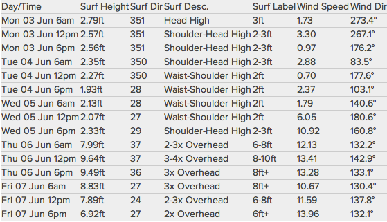
Our internal model guidance actually has a peak on Thursday around 8-10ft at Cloudbreak (see screen capture below) however given there had been a couple of days since my previous forecast, I decided to slightly underplay it and wait to see how the satellite returns came back. Yesterday's 00Z run actually backed off the strength of the low from Saturday's 12Z run, so I tried to pre-empt the final trend now that we're drawing closer to the low forming.
Also worth keeping in mind that a lot of the size in the model output (wave height) is actually a combination of windswell and groundswell. Under these kinds of situations - where the weather system is geographically closer than usual to the target reef - I tend to fall on the underside of the model forecast, just to be safe. But you're correct, it could very well be nudged back up into the 8-10ft range if the next few model runs restrengthen the low.
Just a side note - you'll note that our model is only calling for 2ft Wednesday increasing to 2-3ft late, however we've got a small tweak to our forecast algorithm (yet to be implemented) which would bump this particular swell event up a little (however wouldn't affect wave heights from any other day).
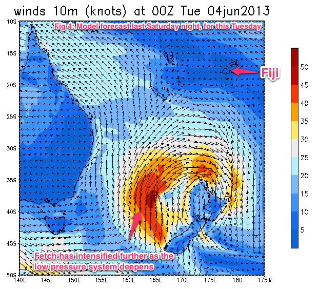
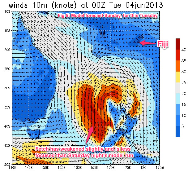
BTW, it's pretty interesting seeing how GFS modeled the formation of this low (see charts below from Thursday thru Sunday, all for 00Z Tues).
Thanks Ben. Regarding your internal model screen capture.....where's the swell period, and why is the swell direction from the NE?
Swell period will be displayed on another page (what you see there is topline data from our database, which we use for general verification), and isn't meant to be displayed in this format.
Also, swell direction is actually the opposite of what's displayed - it's SW even though it says NE, because that's standard oceanographic convention (which, confusingly, is the opposite of standard meteorological convention). Obviously, when we display it on our site we'll add (or minus) 180 degrees.
As for the exact swell periods at the height of Thursday's swell (8-10ft), our model has a couple of trains at that point in time:
3.2m @ 13.7s (37deg ie SW)
1.0m @ 5.2 (334deg ie SE)
0.3m @ 11.9 (338deg ie SE)
Latest GFS update has downgraded slightly, so I'm inclined to stick with 6-8ft+ as a broad overview for Thurs/Fri at this stage. Still, satellite data of core wind speeds won't be through 'till tomorrow arvo (or even later) so we'll see how it ends up performing then.
Volcom Fiji Pro Surf Forecast
Notes prepared by Ben Matson
Next Forecast: Tuesday 4th June 6pm AEST
Key Points
*Mainly small long range SW groundswells expected Tuesday
*Slight increase in size on Wednesday, but very inconsistent at times
*Large surf Thurs/Fri with generally good winds
*please note - we are using 'surfers feet' scale for estimated wave heights, which is: head high = 3ft, overhead = 4ft, several feet overhead = 5ft, double overhead = 6ft, etc*
Cloudbreak 5+ day surf forecast
Tues: Slow, inconsistent mix of swells around 2-3ft with light variable winds. New long range SW groundswell may start to show late afternoon with occasional 3-4ft sets towards dusk.
Wed: Very inconsistent SW groundswell around 3-4ft with light variable winds for much of the day, may tend S'ly late a'noon. Chance for a few bigger sets late a'noon from a new W/SW swell.
Thurs: Solid SW swell with set waves building to a peak around 6-8ft+, may ease a little into the a'noon. Moderate to fresh SE winds developing during the day (may be lighter early).
Fri: Secondary pulse of S/SW swell with an early peak around 6-8ft+, easing steadily throughout the day. Moderate to fresh SE winds throughout the day (may be lighter early).
Sat: Easing S/SW groundswell from 4-6ft to 3-5ft during the day, and becoming less consistent. Moderate to fresh SE winds throughout the day (may be lighter early).
Longer term: Inconsistent new SW swell rebuilding during Sun, easing Mon. Moderate but very inconsistent swells Tues/Wed, ahead of a possible kick in size Thurs, all with generally favourable winds.
Explanatory notes
Wave heights at Cloudbreak were generally within size estimates today, and conditions were clean with light variable winds.
There's no major change to the short term forecast period. We're looking at a small new long range SW groundswell filling into the region on Wednesday. This should produce small, very inconsistent surf in the 2-3ft range however some bigger sets may fill in late afternoon, being the leading edge of a second distant groundswell expected on Wednesday. Winds should be light and variable with generally clean conditions.
Wednesday should see slightly bigger waves than Tuesday (only just), but it'll be equally inconsistent. All of these early-mid week swells will have been generated far below Australia in the Southern Ocean, so the enormous travel distance will iron out all but the largest swell trains. However, conditions should be clean for the most part with light variable winds; a late southerly tendency is possible as a weak trough clears to the east and a new high ridges in from the west.
Yesterday's forecast notes suggested that the leading edge of a stronger W/SW groundswell may show up in the few hours before dark on Wednesday (originating from the developing low in the Tasman Sea), however the latest model guidance has wound back the timing of this to overnight on Wednesday. So, confidence is low that we'll see a noticeable kick before close of business Wednesday. We'll have satellite confirmation of this storm by Tuesday so we'll be able to fine tune this in tomorrow's notes.
Thursday's where things are really going to start happening for the Volcom Fiji Pro. As discussed yesterday, a deep low in the Tasman is expected to merge with an advancing frontal system in the Southern Ocean over the coming days, producing S/SW gales through the bulk of the Tasman Sea. Model guidance is still a little topsy-turvy on the strength and alignment of this system (in actual fact, it's downgraded a smidge since yesterday), but I'm going to hold steady with a call for a peak around 6-8ft+ at Cloudbreak on Thursday. Winds will be moderate to fresh SE, which should be manageable at Cloudbreak however Restaurants will obviously be cleaner (albeit much smaller, perhaps 3ft, occ 4ft at times).
A secondary pulse of swell from the same system is due to fill in overnight Thursday and peak early Friday before slowly easing throughout the day. I still think we'll see solid 6-8ft+ sets early morning but it'll taper off in size during the afternoon. The forecast ridge of high pressure across the region will hold steady so winds should remain similar.
The weekend looks really good, albeit smaller in size than the end of this week. We're looking at a steady drop in size through Saturday with similar winds as per the end of this week (moderate to fresh SE), ahead of a new long range SW groundswell filling in during Sunday, peaking late in the afternoon with inconsistent 4-5ft sets. This swell is expected to be generated by an intense but fast moving front just south of the lower Tasman Sea this weekend, which will push only fleetingly into our swell window. So, expect set waves to be very inconsistent (especially in comparison to the Thurs/Fri swells, which should be reasonably consistent by Fijian standards).
Looking further ahead, and slightly smaller swells are expected for the first half of next week - several long range groundswells will push the region, but as they will have been generated way below the Australia continent, we can expect significantly greater waits between set waves. That being said, if local conditions are favourable as models are suggesting, wave quality could be good in the 3-4ft range - there's just always some concern as to the contestability of super inconsistent long range groundswells.
Computer models are still in agreement that we may see one final pulse of bigger swell for the last day of the waiting period, but at this point in time it's too early to pin down specifics. Let's take a closer look in tomorrow's forecast notes.

Is it just my imagination, or is that Low doing something unnatural and slightly degrading to the North Island of NZ?
Out of curiosity, what are the implications for NZ of something like that forming there, in terms of swell and weather conditions?
Hmm.. I'm surprised they're running this morning, especially with such a positive forecast ahead. However wave heights are a little bigger than forecast - looks like the increase later this afternoon is already in the water (3-4ft).
Today is also a classic example of what long swell periods can do with tiny swells - this morning's model forecast was only 0.85m of deepwater SW swell but swell periods were expected to be in the 18 second range.
Whaddya mean "unnatural and slightly degrading", surfstarved?
Wow, after a slow start (five or six 1-point rides in the first ten to fifteen minutes) a solid set just came through in the 4-6ft range. Haven't seen anything since.
Anyone got any alternative web addresses to watch the pro? My work has blocked the video footage on the Volcolm website!!!!!
Bummer Don. Try the Red Bull website instead:
http://www.redbull.com/en/surfing/stories/1331593624937/watch-live-volco...
Thanks Ben but my IT department appear to be clever and have blocked the video image on that site also!!! :(
Also, I see from your forecast last night that you've stuck to your 6-8ft+ call, but noted that the models have wound the forecast swell for Thursday down slightly. From what I'm looking at they appear to have wound it back up again in the GFS 18z run!!!
Yeah it's wound back up a bit this morning. I prefer to avoid the 06Z and 18Z runs though, and will wait for the 00Z run to clarify.
Well as suspected, it looks as though the pros won't be surfing 10-12ft Cloudy on Thursday. Surfline already alluding to Resties being the venue for Thursday:
"THURSDAY 6th: Building and solid
Swell/Surf: Solid, mid period SW swell looking very likely, assuming storm behaves as forecast in the next 24 hours. For Cloudbreak we're looking at surf running 2-3 times++ overhead with larger sets very possible. The swell direction, swell period and even wind would make for good conditions at Restaurants. Stay tuned.
Wind/Weather: Moderate SE trades 10-15kts."
"We'll remain conservative on size, but overall this continues to look very solid on the charts/models with potential for double to triple overhead+++ waves at Cloudbreak. Note at this size and swell period, Cloudbreak will be a little unuly. Restaurants would offer more manageable conditions and high quality surf based on the swell direction, period and local wind conditions (SE trades)."
Maybe Don. But based on the last few years I suspect they'll be keen to surf Cloudbreak if winds are manageable, which they may very well be.
Also, Surfline are giving themselves lots of wiggle room with their forecast: "2-3 times++ overhead with larger sets very possible".
What exactly is 3++ times overhead? Three and a half or four? And then 'larger sets very possible'..
So essentially they're saying anywhere between double overhead to four times overhead. In 'surfers feet' that's 6-12ft (or in face feet that's 10-20ft).
Kinda hard to get the forecast wrong when you give yourself such a large margin of error.
Cloudy does get into a size range above about 10 ft though where it doesn't really work too well as the bigger set waves start capping on the second reef. You kind of have to sit in copping the wash throughs on the head to catch the smaller inside waves which tend to have a wonk to them anyway.
At that point Restaurants is usally 4-6ft and picture perfect and they've always tended to run there in the past in that size range.

What's the story with Parko's heat? (Round 1, Heat 3) - he didn't register a score. Does that mean he has withdrawn?
Cloudy does get into a size range above about 10 ft though where it doesn't really work too well as the bigger set waves start capping on the second reef.
By: "lolo"
Last year's footage of Cloudbreak kinda disproved that theory.
I reckon it'll come down to the winds. Models have the southern extent of the trades just south of Fiji, so they may not do a huge amount of damage to the swell. If they're 15kts locally it'll be fine. If it's 20-25kts (or more) it'll become difficult and they'll switch to Restaurants.
What's the story with Parko's heat? (Round 1, Heat 3) - he didn't register a score. Does that mean he has withdrawn?
By: "maddogmorley"
Parko was out fishing. I tell no lie.
What about Slater bud??
3Kelly SlaterUSA + 0.00
1Miguel PupoBRA 7.17 + 4.83 12.00
2Aca LalabalavuFJI 4.67 + 3.83 8.50

According the webcast, Kelly is late getting to Fiji as his bro' is about to become a new dad and Kelly is there to witness it.
Both him and Parko are relegated to round two without even catching a wave.
RE: Parko missing heat
What a joke! This is supposed to be the world's best surfing athletes vying to be world champion. This bloke's title prospects were on a knife's edge as it was let alone forgoing his 1st round heat in 4-6 foot flawless Cloudbreak.......yeah they're living the dream, staying at Namotu, etc ,etc but all that is required is to turn up for your heat. Too spoilt. Most people would chop lefty off to be where he is.
Kelly? Well that's a bit different in my book - family's family

I agree Staitey, how's professional surfing supposed to be taken seriously when one of the top 5 doesn't even show for his heat and is off fishing.
It's equivalent to a footy player having a big night before a game or some other unprofessional act.
I'm more surprised at some of the comments on Facebook. "Parko's a world champ, so he can do what he wants" etc.
No he's not, he's an athlete competing on the ASP World Tour. Parko's in Fiji to compete. That means waiting for the call every morning (and the call at first light today was "On Hold").
If Rodger Federer missed the first round of the Australian Open because he decided to take a last minute winery tour of the Yarra, there'd be a huge uproar. This is no different.
Just proves to me that some of these guys don't know how good they have it. Makes an Aussie like me take someone like Adriano De Souza a little bit more seriously given his commitment and dedication to the sport
parko you are a fucking disgrace.
All you guys hating on parko are the disgraces. The guy made a mistake, obviously he was certain they wouldnt run due to a better forecast for later in the waiting period. Yeah he fucked up but maybe you should have a go at the asp system. Hes still just as much in the contest without showing up for his heat. Whats the point of running a full day of competition in which no one even loses? He has no obligation to you armchair critics to compete. He can quit tomorrow if he likes. He wont be in the running for a title this year but so what? Kelly has missed contests he didnt feel like going to by blaming dubious injuries. Mick had years following his wins that seemed like he was just cruising. The point is: I doubt anyone is more dissapointed at Joel missing his heat than himself and really no one else has the right to crook on him. Hope he comes back now and wins a few heats to prove that round 1 is a waste of time.

Parko's missed heat may not be a good thing for the asp but he can do what ever he wants... He's an individual just like everyone else.
Last year's footage of Cloudbreak kinda disproved that theory.
By: "thermalben"
I guess I should have been more specific. Last years footage shows what happens at third reef Cloudbreak when it gets over 15ft or so. There's plenty of all time footage that shows that.
In the 10-12-15ft range it doesn't hit the outside (third) reef and the second reef fucks it up. It rarely works well in that kind of size range, regardless of the winds. There's definitely a window of swell size that Cloudbreak doesn't handle so well.
Manners
Professional athletes should act as such, fuck making a mistake as an excuse. Dude should have been there ready to go. Not only did he miss out on surfing great waves but he did himself a great injustice. He will get killed by all the internet haters. Why? For a 20 kilo Spaniard. Hardly seems worth it.
what if sooky sooky medina had gone fishing ? instead of surfing his heat ? 90% of swellnet readers would be shitcanning him.
So very true udo.
Volcom Fiji Pro Surf Forecast
Notes prepared by Ben Matson
Next Forecast: Wednesday 5th June 6pm AEST
Key Points
* Inconsistent SW swell for Wednesday
* Large surf Thurs/Fri with moderate to fresh SE winds
* Easing swell Saturday, levelling out Sunday
* Strong long period groundswell due late Mon/Tues with great conditions
*please note - we are using 'surfers feet' scale for estimated wave heights, which is: head high = 3ft, overhead = 4ft, several feet overhead = 5ft, double overhead = 6ft, etc*
Cloudbreak 5+ day surf forecast
Wed: Very inconsistent SW groundswell between 3ft and 5ft (expect long breaks of small waves between sets). Light variable winds for much of the day, may tend S'ly late a'noon. Chance for a few bigger sets close to dusk from a new groundswell.
Thurs: Solid SW swell building to an a'noon peak around 8-10ft+. Moderate to fresh SE winds developing during the day (may be lighter early).
Fri: Early peak around 8-10ft, easing to 6-8ft from mid-morning onwards. Moderate to fresh SE winds throughout the day (may be lighter early).
Sat: Easing S/SW groundswell from 5-6ft to 3-5ft during the day, and becoming less consistent. Moderate to fresh SE winds throughout the day (may be lighter early).
Sun: New SW groundswell rebuilding to 4-5ft, but with long breaks between the sets. Moderate SE winds (may be lighter early).
Longer term: Smaller surf early Monday ahead of an a'noon kick in strong long range groundswell that should peak early Tuesday. Mainly light to moderate E/SE winds.
Explanatory notes
Rightio. Let me be totally upfront: I got today's forecast wrong. And more so, I'm somewhat baffled as to how this swell reached the size that it did at Cloudbreak.
Ordinarily, when I produce an incorrect forecast there's usually a way to 'hindcast' and see where I took a wrong step. Sometimes I may have glossed over some observational data or missed an important trend between model runs. But in this case it's very difficult to find any evidence to support a groundswell generated below Australia - by a relatively bog-standard weather system that didn't even enter the Tasman Sea - delivering solid 6ft to just shy of 8ft sets at Cloudbreak (ie 12ft+ faces on bomb sets), as we saw today.
Computer models had today's swell peaking at around 0.95m at 17 seconds (around dusk), which I figured might reach 3-4ft at Cloudbreak, based on previous swells. Obviously this swell arrived much earlier than expected, and was bigger in size - but unfortunately without any useful observational data inside Fiji's swell window there was no way to confirm these facts ahead of time. Even with the benefit of hindcasting there's no reason why this particular swell would have stood out against other events expected over the coming week.
So, how does today's undercall affect future forecasts? To be honest, not a great deal. My gut feel is that the computer models poorly initialised the initial low pressure system responsible for this particular swell (way down in the Southern Ocean). The quasi-exponential relationship between swell periods and wave heights in the surf zone - which increases the size of the surf more significantly with larger periods - ended up magnifying what was probably just a small undercall by the wave model (another 0.75m in height and another second in period would have produced a model surf forecast of around 6ft).
Therefore, we're looking at a small drop in size at Cloudbreak on Wednesday compared to today. The current swell event (which is already ahead of schedule) will slowly drop its period over the coming 24 hours, so even though ocean wave heights will remain similar to today, we'll see surf size drop by a foot or two and set waves become even less consistent.
Winds will be light and variable in the morning, however a southerly tendency is likely into the afternoon as a weak trough clears to the east and a new high ridges in from the west.
New swell from the Tasman Low is expected to start muscling up across Fijian waters on Wednesday evening. There's still a chance for a few bombs to appear in the few hours before dark however model guidance is suggesting we'll see the first major pulse will push through between 8-10pm. So, don't hang out for anything major late in the day but there is certainly a chance for a distinct change in energy around dusk.
Computer models have also upgraded the specs of this Tasman Low since yesterday's model runs. They've slightly strengthened core wind speeds as well as broadening the overall fetch, which should boost wave heights into the 8-10ft+ range at Cloudbreak on Thursday - we're close enough to the evolution of this weather system to pull back on any conservatism from my end. However a few slight changes in the way the low forms has delayed Thursday's peak; we're now more likely to see maximum wave heights in the afternoon rather than the morning. As for local winds, we can expect moderate to fresh SE trades for the most part, possibly a little lighter early in the day.
This swell is expected to hold through the night and peak just before dawn before easing slowly throughout Friday. As such, I'm going to maintain an outlook of 8-10ft early Friday before easing to 6-8ft throughout the day. Similar winds are expected on Friday; moderate to fresh trades for much of the day.
Easing swells will continue throughout Saturday (5-6ft down to 4-5ft) along with a similar wind regime as per the previous few days. A small to moderate long range groundswell generated by a fast moving frontal system below Tasmania will kick up a new swell for Sunday but it'll be smaller in size than the previous few days (probably maintaining a similar height as per Saturday afternoon, ie 4-5ft), and will peak in the afternoon.
Monday will start off initially smaller however we've got a very good long range groundswell lining up to peak early Tuesday, that should start to appear on Monday afternoon (model forecasts have moved a few things around since yesterday and have essentially wiped the projected swell for the last day of the waiting period). The late Monday/Tuesday swell will be generated by a particular impressive low pressure system that's modelled to spin up - and then stall for a period of time - this Thursday and Friday, well to the south-west of Tasmania.
Although this is a very large distance from Fiji, the sheer strength and coverage of this storm should generate inconsistent bombs in the 6-8ft range at Cloudbreak possibly as early as late Monday, more likely early Tuesday. And at this stage, current expectations are that the dominant ridge across Fijian waters (from Thurs-Sun) will relax by this time, allowing winds to become light E/SE. More on this in tomorrow's update.
Whaddya mean "unnatural and slightly degrading", surfstarved?
By: "thermalben"
"unnatural and slightly degrading" = weather that leaves you feeling used and abused. It's a family website Ben, so I was trying to avoid being too explicit.
Basically, with the Low wrapping itself around the top of the North Island like it seemed to be in your previous image, I figured they were in for an almighty rogering - storms, maybe even tornadoes like the one that hit (was it Auckland?) last year.
I still think its no big deal. Hes still in the comp. The way the natural footers went and heitors 19+ total means parko would likely still be in the same position surfing in round 2. Round 1 often runs through a whole day of decent waves in a comp waiting period and barely achieves anything. Perhaps the top seeds should start straight from round three, shrink round 1 to 6 or so 3 man elimination heats for the lower seeds and wild card guys to battle for the right to move forward. Ps I dont know many people that would be given time off work for the birth a nephew/niece......
Ben, just throwing it out there, but could yesterday's swell have been from the more locally generated S/SE swell that was also forecast to be in the water?
I'm thinking not, given the major inconsistency in the swell that I saw, but just throwing it out there as another possible scenario?
I don't think that fetch was aimed properly towards the region to have been responsible for yesterday's waves. Also, I've been given good advice that SE swells don't perform especially well at Cloudbreak due to sheltering by islands to the southeast.
I'm just going to chalk it up to a very long range, long period groundswell where a large percentage of the bulk swell energy was in the upper periods (I was expecting it to be in the mid range periods ie 14-15 seconds).

Fetch!!!
My little jack russell (Ninja) is a great fetch, she brings back everything. In the weather world who made up fetch and where does it come from??
Who do you think is gonnna win the Volcom Fiji Pro???
Put your bets down now. ( CJ )
Intense forecasting Ben great work, if your number plate is the same, I will be following you to the surf.
Don could you explain your in depth swell forecast for this comp, wouldn't mind having a look at it??
Cheers
Volcom Fiji Pro Surf Forecast
Notes prepared by Ben Matson
Next Forecast: Thursday 6th June 6pm AEST
Key Points
* Large surf Thurs/Fri with moderate to fresh SE winds developing
* Easing size all day Saturday, levelling out Sunday with a new SW swell
* Strong long period groundswell due late Mon/Tues with freshening SE winds
*please note - we are using 'surfers feet' scale for estimated wave heights, which is: head high = 3ft, overhead = 4ft, several feet overhead = 5ft, double overhead = 6ft, etc*
Cloudbreak 5+ day surf forecast
Thurs: Solid SW swell building to an a'noon peak around 8-10ft (may be smaller at first). Moderate to fresh SE winds developing during the day (may be lighter early).
Fri: Early peak around 8ft+, easing to 6-8ft from mid-morning onwards and down to 6ft by the a'noon. Moderate to fresh SE winds throughout the day (may be lighter early).
Sat: Easing S/SW groundswell from 4-6ft to 3-5ft during the day, and becoming less consistent. Moderate to fresh SE winds throughout the day (may be lighter early).
Sun: New SW groundswell rebuilding to 4-5ft, but with long breaks between the sets. Moderate SE winds easing.
Mon: Inconsistent long period SW groundswell building all day towards a late peak around 5-6ft+. Early light SE winds, freshening during the day.
Longer term: Solid SW groundswell Tues with SE winds. Size easing slowly Wed/Thurs with favourable winds.
Explanatory notes
Not many changes to make to yesterday's forecast. Today's surf came in broadly within expectations (generally 3-4ft, with one or two 4-5ft sets noted during the VQS webcast). Winds were light and variable in the morning ahead of a developing southerly later. As yet I've had no confirmation of any new groundswell arriving at Tavarua from the Tasman Low, however we're so close to the impending new swell that it doesn't matter much anyway.
That being said, I will shave off the 'plus' on Thursday's forecast, and will also slightly downgrade Friday's size (just a smidge). The reason for this is that the satellite derived winds finally came through this morning to clarify the strength of the Tasman Low, and wind speeds around the low ended up being a little weaker than the models predicted.
However, the close proximity of the low to Fiji and its otherwise impressive structure should still see an afternoon kick into the 8-10ft range at Cloudbreak on Thursday, before easing from 8ft+ at dawn on Friday down to about 6ft or so by that afternoon.
As for local conditions, we're looking at freshening SE winds all day Thursday - they're likely to be only light to moderate early morning, but will reach fresh strengths (15-20kts) into the afternoon. This is borderline for Cloudbreak so it's difficult to say how much it'll affect the surf, because the southern reaches of the fetch won't extend very far south of Fiji (unlike last weekend's winds which were entrenched across quite a broad region). The wind regime will maintain strength through Friday so any window of lighter winds early morning will be only brief at best.
In any case there should be more than enough size for quality Restaurants both days, peaking 4-6ft Thursday afternoon, down to 3-5ft early Friday and smaller into the afternoon.
Saturday will see this swell event easing steadily, and fresh SE winds will make for occasionally blustery conditions at Cloudbreak at times. This is my least favourite day of the waiting period, mainly because of the winds and because we'll be on the backside of the swell event - and also with several more swells looming for the coming days.
Sunday looks pretty good. A new long range SW groundswell is expected to arrive during the day, rebuilding to 4-5ft+ however of greater importance is the ridge of high pressure across the region, which is expected to slowly break down. This means SE winds will slowly ease in strength. Set waves will be very inconsistent but there should be some very good waves on offer.
For the rest of the waiting period we've got some great long range swell to look forward to. An incredible low pressure system is developing well south of Australia at the moment, and is expected to reach a peak through tomorrow - spanning much of the Southern Ocean south-west of Tasmania, and exhibiting gale to storm force winds. Additionally, this low is expected to stall for a day or so, which is somewhat unusual for weather systems in this neck of the woods (and is a positive development for Fiji's swell potential).
This system is expected to generate a couple of very long period swells (leading edge of ~20 seconds) arriving early Monday, building during the day ahead of a peak in size on Tuesday. At this stage we'll also see SE winds freshening about the region as a new ridge of high pressure muscles in from the west, however conditions should remain favourable at Cloudbreak.
Size wise, the initial upwards trend on Monday should reach an inconsistent 5-6ft+ at Cloudbreak by the afternoon, ahead of a peak in size on Tuesday somewhere above 6ft and maybe even closer to 8ft if we're lucky. However the large travel distance from the swell source to Fiji will result in a very pulsey swell event, with occasional long breaks of smaller conditions.
From here on, model guidance is suggesting only a slow easing trend in size through Wednesday and Thursday with no significant swells expected to push through before the end of the waiting period.
How's this for a difference of wind conditions - the ASP are calling 'windy conditions' out at Cloudbreak, yet 10km away at the Nadi International Airport, it's calm.
http://weather.noaa.gov/weather/current/NFFN.html
Certainly easy to see why too with all of the high mountains close to the coast.
Should be a great day of viewing, Restaurants is reportedly 4-6ft and clean.
How were those waves today 'eh?
Phwoarrrr!!!
So much good surfing on offer. John John killed it and how hot is his mum? Smokin'. Cruising with Brian Bielman. Anybody remember Gina Bielman?
Anyhoo, the heat I'm really looking forward to is Kelly and Mitch C. That's going to be a blinder.
Thanks for the updates Ben.
Soooo... anybody remember Brazil?
So true Zen,
Its hard to pick a winner, no wonder No one wanted to bet on someone so early.
Jordy Smith was killing it too, his style suits powerful waves big time.
Gina who?
Had some Brazil nuts today with my beer in between heats.
Go Fiji
Volcom Fiji Pro Surf Forecast
Notes prepared by Ben Matson
Next Forecast: Friday 7th June 6pm AEST
Key Points
* Large surf easing during Fri with moderate to fresh SE winds
* Easing size all day Saturday, levelling out Sunday with a new SW swell
* Strong long period groundswell due late Mon/Tues and maybe early Wed with light to moderate E/SE winds
*please note - we are using 'surfers feet' scale for estimated wave heights, which is: head high = 3ft, overhead = 4ft, several feet overhead = 5ft, double overhead = 6ft, etc*
Cloudbreak 5+ day surf forecast
Fri: Early peak around 8-10ft, easing to 6-8ft from mid-morning onwards and down to about 6ft by the late a'noon. Restaurants easing from 4-6ft to 3-4ft during the day, and becoming less consistent. Moderate to fresh SE winds throughout the day.
Sat: Easing S/SW groundswell from 4-6ft to 3-5ft during the day, and becoming less consistent. Moderate to fresh SE winds throughout the day (may be lighter early).
Sun: New SW groundswell rebuilding to 4-5ft, but with long breaks between the sets. Moderate SE winds easing.
Mon: Very inconsistent long period SW groundswell building all day towards a late peak around 5-6ft+. Smaller surf early morning. Expect long breaks between the bigger waves. Light to moderate E/SE winds.
Tues: Very inconsistent long period SW groundswell with set waves pushing above 6ft at times, possibly near 8ft. Expect long breaks between the bigger waves. Light to moderate E/SE winds.
Longer term: Solid SW groundswell holding into Wed morning but easing during the day.
Explanatory notes
No shortage of size in Fiji today with wave heights coming in a little above expectations at Restaurants (I haven't had any size confirmation from Cloudbreak as yet). Although quite complex to measure in size, due to the way the wave grows down the reef, Restaurants managed consistent 4-6ft sets for much of the day with a couple of bombs nudging the 6-8ft range at times.
Winds were fresh and gusty SE for much of the day. Interestingly, wind speeds at the Nadi airport were light and variable all morning, with a southerly breeze increasing to around 15kts in the afternoon - quite a contrast to Tavarua (and is the result of local topography).
So, let's keep things simple - there are no major changes to the short term forecast. We're looking at a large, slowly easing swell from Friday morning onwards, with the swell direction starting to show a little more southerly tendency than what we saw today. This is likely to affect Restaurants more so than Cloudbreak; that being said, Restaurants should still offer excellent waves on Friday, mainly in the morning before it starts to drop more noticeably in size.
The easing trend will continue through Saturday before bottoming out in the early hours of Sunday morning. A moderate pulse of fresh SW swell is expected to fill in during Sunday (towards an afternoon peak) but size wise it'll be best suited to Cloudbreak. As for local conditions, we can expect similarly fresh and gusty SE winds for the next few days, slowly easing through Sunday.
Monday is where things start to get very interesting. A broad and deep low pressure system to the south-west of Tasmania is stalling in its west-east trajectory, which is quite unusual for this neck of the woods. Gale to storm force westerly winds about the low are generating a large long period swell that will push up through the Tasman Sea over the weekend, with its leading edge modelled to arrive at Tavarua on Monday morning. The resulting open ocean swell in Fijian waters won't be very large, however last Tuesday showed just what the effects of a large swell period can do at Cloudbreak - and I think we're going to see something similar happening this time around too.
At this stage we can look forward to a couple of pulses of swell between Monday afternoon, Tuesday and maybe even early Wednesday, and size could push up above 6ft at Cloudbreak, possibly even hitting the 8ft range. Current expectations are that Tuesday afternoon will see the peak of this swell event.
Even better - yesterday's suggestion in the model runs that a ridge of high pressure would restrengthen across the region (freshening SE winds) has been relaxed in the latest developments, which means we could be looking at light to moderate E/SE winds.
So, with no shortage of great swell on offer for the next week, there should be plenty of quality days to pick and choose from. I'll update the Mon/Tues/Wed swell in more detail tomorrow - hopefully we'll have some satellite confirmation of surface wind speeds by then.
Top report on the days results at the volcom pro today. after reading the report on swell net i thought i'd check out the other web site.. and noticed the same report seemingly written by the same journo? why don't the journos get a credit of some sort for each report. Just a thought. Finally , any chance of forecasting in some easterlies over here in WA to go with the swell we're getting. Go Swell Net! Go Parko!

G'Day TS,
It may be that you've read the press release? Press releases will always be noted 'press release' under the title and usually begin with italicised information i.e 'RESTAURANTS, Tavarua/Fiji (Thursday, June 6, 2013)'
Our exclusive coverage is being done by Braithy and is found under the 'Semi Pro Shakedown' heading. His latest one is here: http://www.swellnet.com.au/news/3654-semi-pro-shakedown-sports-mad
"The Spartan's approach to heavy waves is much like his approach to tennis, which goes something like this: stand at the net and smash everything back with extreme prejudice. Unfortunately for Bourez he came up against Wilko on a good hair day and got smoked. Wilko abused the lip like it owed him beer money."
Looks like that new swell for the last few days of the waiting period has been pushed back a notch Ben (ie probably won't be in the water until Tuesday me thinks). Which is not usually a good sign if GFS keeps pushing it back somewhat.
Question is, will the event organisors hold out for the finals on the last day of the waiting period (Wed 12th)?
Rather than keeping all of our forecasting notes internal, I thought it'd be worth documenting the forecasting procedure for the Volcom Fiji Pro. We did our first forecast for the event yesterday and I'll post it up shortly. If you've got any questions, Craig and I are also happy to answer them.