Why Does High Pressure "Block" swell?

Hi Jon,
I'll get back to you a little later today once I've got some free time between forecasts.
Cheers, Craig

Max,
The analogy I use for highs and lows is that lows are like the pinballs bouncing all around the place and the highs are the bumpers deflecting the lows away. A 'blocking high' is a slow-moving, big bastard of a high that bounces low pressure systems - and hence prevents swell formation - happening at a particular region.
I'm sure Craig will have a better explanation shortly...

HEY STU AND CRAIG....This is opportune as I was going to throw this theory of mine at you some time ago when you did a piece on Kirra being a myth...but i couldn't find the article..anyway, it probably relates more to this point...
I have a theory that most or at least a lot of cyclone swells on the Gold Coast are a myth, at least the classic surf ones.
Here's my thoughts, without any serious expertise, but ...a lot of the best days on Gold Coast/Northern NSW happen when there's a cyclone up north and a blocked high sitting underneath with a strong ESE wind fetch...and Tasman swells....the swell isn't actually cyclone swell, but the cyclone does act to block the high, maintain strong SE wind and swell fetch and deliver excellent surf...think there's any basis on this theory?
Not talking about the cyclones that sit way offshore and directly out to the east, just about the ones that linger north.

You got it right with the high part, but cyclones don't block the high.
It's the other way around.
There's a myriad of combinations from a strong high that can cause excellent surf: offshore troughs, small lows in the trough, hybrid lows, easterly dips, slow moving tropical depressions etc etc and even just the fetch from top of a strong semi-stationary high.
Cyclone swells per se aren't a myth, but the belief that every cyclone in the Coral Sea or South Pacific will produce good surf is just that.
Mostly, a cyclone without a cradling high will race away or cross the coast and not produce much surf.
TC Fina was a great example of how a cyclone can become an extra-tropical low and produce great surf due to a strong cradling high.
so...a lot of those cyclones that sit up north...don't actually produce the swells that deliver the waves, but do help in "cradling" the high undernaeth into an excellent system that helps deliver perfect surf? and through the 70/80's even 90's...without the benefit of swell charts and wam models, we all thought the cyclone was the engine room of many of those swells?
Unless the cyclone is in the swell window it can't produce swell.
And the cyclones don't cradle the high, it's the other way around.
If no high the cyclone will go wherever the steering winds send it.
Usually if there is a strong high there is a precursor tradewind swell before the actual cyclone swell....these tradewind swells are often mislabled as cyclone swells.
Hi Robbo,
The biggest and longest lasting swell events develop when you have a big cradling high in the Tasman Sea producing a broad fetch of easterly trades on its northern flank (top of the high).
When a Cyclone develops in the Coral Sea and squeezes the northern top of the high it produces large pulses of swell which usually last longer than just a solitary Cyclone swell due to the high helping to stall and support the Cyclone in the same area, and also because the Cyclone is activating on an already active and energised sea state.
But back to Jon's question, below are two diagrams off two different weather synoptic setups relative to Victoria.
1)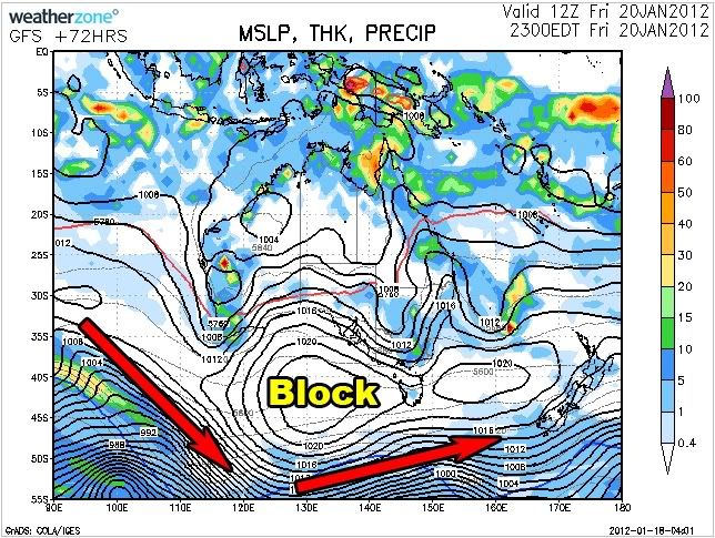
The first image shows the synoptic setup for this Friday and you can see there is a big strong high sitting in the Bight. High pressure systems are stable and broad systems, and as a result any low or cold front trying to move towards it are deflected around its edges.
I've drawn arrows indicating how any cold fronts approaching WA are deflected on a south-east track towards Antarctica. But a cold front passes under the high and over to the other side towards Tasmania, it is free to move back up towards New Zealand on a more east-northeast track.
The term "Block" refers to the effect the high has on the regions swell potential, and with a strong high in the Bight, Victoria's swell potential is greatly limited. This is because cold fronts aren't able to push up towards and into the state as is ideal for large swells to be generated.
2)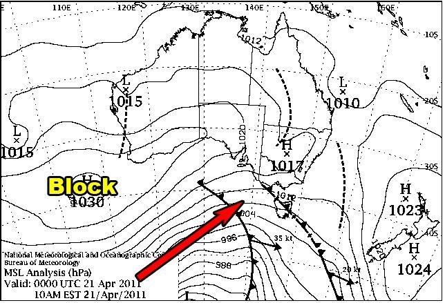
This second synoptic chart shows the weather setup during the 50th Anniversary of the Rip Curl Pro last year where there was non-stop and large swell.
You can see the high pressure system is over to the south-west of WA, therefore a block is in position for WA, while cold fronts are directed on the eastern flank of the high, up towards and into Victoria. So this is the setup you want with front after front pushing up into the state.
The way these blocks and highs move around the Southern Hemisphere is explained here, but you might want to take some time to mull over the above explanation first.
Long Wave Trough: The Waves That Create Waves
Cheers, Craig

@Jon/MaxC ,
Craig , Whilst right isn't giving you ALL the facts about Vic and Blocking Highs .
This Friday for instance there will still be Swell in certain parts of the state .
Some of it Sth swell , and some West Sth West . Knowing where to look is the Key and something i will keep for myself a few select friends and my boys when they grow up .
Another point that can be made is that not ALL of Vic Faces West .
As for TC's well they really have to linger , and a Cradling High / Blocking high in the Lower Tasman will provide this stalling effect .
As some famous Gold Coast surfers of Years past have discussed , the longest and most enjoyable swells will emanate from a stagnant run of Flat top highs , with Eastern Fetch running half way out to Tahiti .
Oh ,
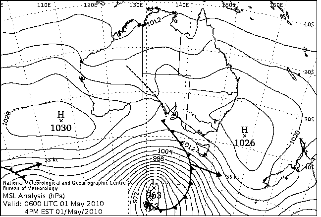
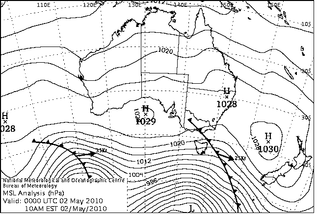
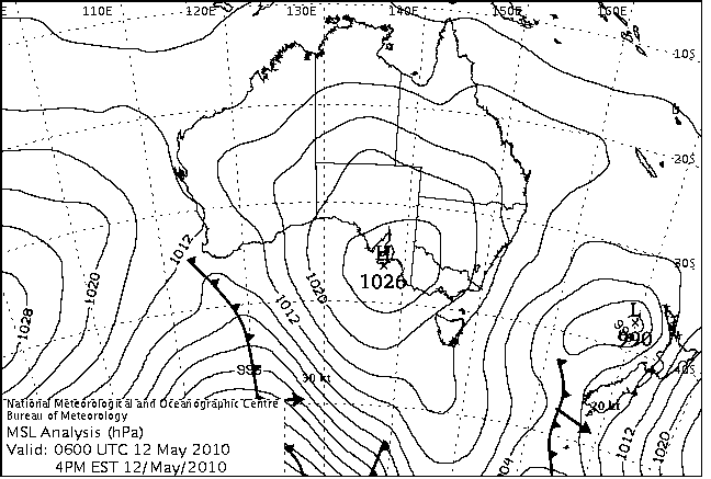
If you have access to archived Charts , The best days for a Victorian outcome that I can Recall . Would be May 2,3,4 2010 . Although this may show how long its been since I've regularly been in the water .
@ Freeride . Ask Bugs about that . If fetch is long enough , there doesn't need to be a Huge Feature .
Think you'll find Southey that even those flat-top highs need to be energised by some kind of tropical feature such as an easterly dip/trough or broad tropical depression.
Especially one that retrogrades from the Vanautu region into the New Cal/North Island swell window.
Southey,
Of course swell still gets in under these blocking patterns, I have that swell in my forecast for Vicco this Friday ;)
The main point is though is that under these patterns no huge or large swells are possible and Vicco/SA are left to rely on longer-range and less consistent groundswells.
You can get those sneaky S/SW swells though as well if a really really strong storm forms just south-west of Tassie and pushes up towards the Tasman Sea
Apologies ,
Craig .
I must admit I don't read yours or others Wave Forecasts , unless I'm heading somewhere other than VIC , SA , WA .
Occasionally I'll look at Buoyweather for local winds forecast 3-4 days out , if planning a Tidal effected Surf . Otherwise extended Models out to 7/8 days . For Planned Jaunts .
PS . Did you look at May dates 2010 .
Craig,
Thanks - that was exactly what I was after - and makes sense to my non-meteorological brain!
Regards,
Jon
No worries Jon.
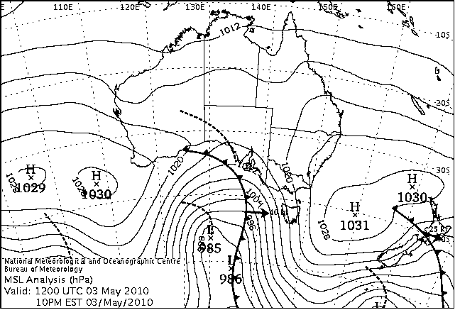
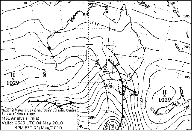
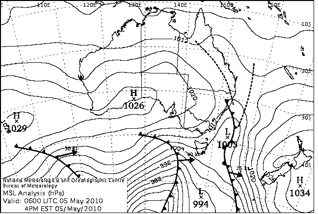
And Southey, I have to say looking at the archive charts from the period your are talking about is absolutely amazing!
There was nearly 14 days of continued and strong storm activity pushing up towards Victoria from the Southern Ocean!
The clincher is that after each strong storm passed, there was always a second one backing it up, swinging winds around to the N/NW to clean up the arriving swell.
Here's a random selection of charts during the period but in order..
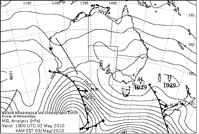
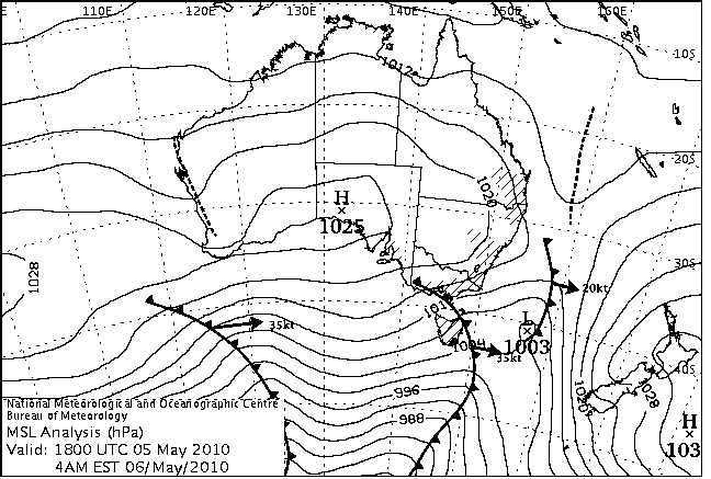
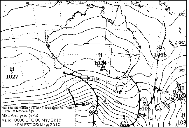
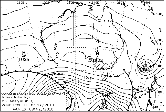
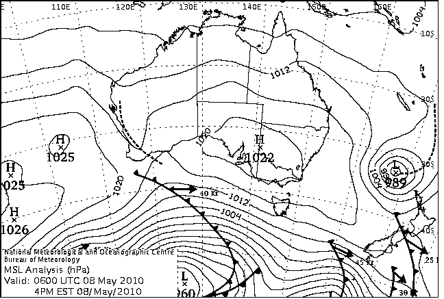
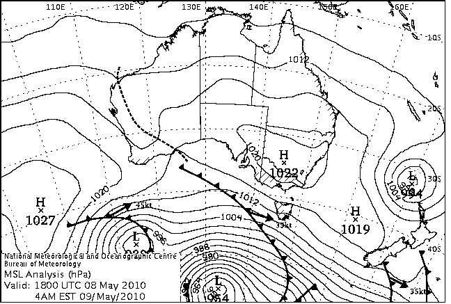
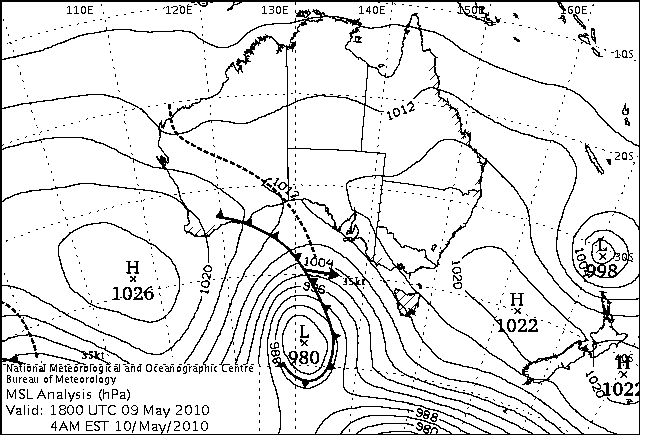
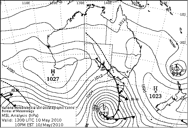
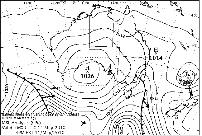
Amazing!!
Craig ,
This sort of Run isn't exceptional by Vic Terms . The fact that these Five to six Fronts / Cut Off's and Just got quicker and Quicker in advance Speed . They were all connected Together the Whole way across the Indian/Southern Ocean , and as you said they all seemed to swing in behind each other with impeccable timing . So half way thru , the Surf Coast probably had Okay , windy waves .
The best thing about it was that the First Front was a Double ( or Camel as I like to put it ) , the heading one Dropped away very Quickly with the two rotating on eash other Clock wise ( second front pushes Nth and Stalls a little ) . So conditions on a certain part of the Coast went From Strong West to light NE in a Period as Short as 12 Hrs . This Still night is rare ish as usually you'll get a short period of Sth wind between . So the 3rd of May you had little in the Way of Morning Sickness ! .
And since there was a front that had "Slid" and another 5 lining up behind it each at increasing advancement speed we are talking a very long distance but consistant SOLID swell .
.
I haven't provided a link on here before but if it didn't work , think of this . WSW 21 ft , 17 sec's , NE 8-10 km/h .
Looks like we can't see that image Southey because your profile may be private? Can you upload it to maybe an image site like photobucket or flickr so we can see?
And yeah as you said, that northwards protruding front pushing towards SA on the 3rd would of created epic conditions across the exposed spots with a light N/NE wind.
Lets hope there's a couple of these setups this year for you guys because last year was a bit of a fizzer regarding continuos large swell energy.
Craig .
I don't give out much info usually . this will probably disapoint .... heheh
"
Haha gold ol' buoyweather ay Southey ;)
Southey, have you heard of Bouyweather's big sister....LOLA? ;)
DW ,
LOLA , that was a song in the 70's . Right .? L - O , L - A .... LOLA ..... ;-)
Nah , I was A FNMOC BUoy , and now nmrl . Kind of Guy . Although I believe EC is better for Your more Northern Waters .
The beauty of nmrl , is they show the entire Oceania on the MSLP chart .
The term "blocking high" is used all the time in swell forcasting (believe me, I've been googling the term to find out what it's about) but why is it so? Particularly interested because the there always seem to be lows whipping round the bottom end of the chart and highs in between us and them. While we're at it, does anyone have a shot of a really good chart (for vic)?
Cheers,
Jon