THE SUPERBANK FORMULA

nicely presented there pshk!
So I guess the pix icon above the reply box is where one places a url that has the picture?
where can those pictures be to be a unique url?
In my opinion the supa bank makes all before and after it developmentally redundant?
Why design something new when you can copy something that works well.
rgds
Bob

THE SUPERBANK FORMULA
Part 2.
Part one showed all the qualities of the Superbank in 2 dimensions, length and breadth, the 3rd aspect is depth.
The sand build up at the Superbank is a gently sloping gradient perpendicular to the peel line.
Here is a diagram.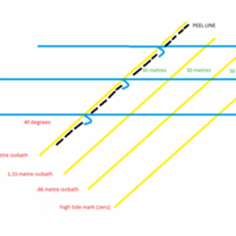
The diagram above shows the peel line of a 1 metre wave (dotted black line)breaking in a depth of 2 metres.
The peel line is 150 metres from the shore line (high tide mark).
The yellow lines are isobaths which are lines joining points of equal depth and are 50 metres apart.
The yellow lines show that the rate of slope is .66m over 50 metres.
The yellow line on the right is the zero level or the high water mark.
The depth along the next yellow line (50 metre isobath) is .66 metres.
The depth along the next yellow line (100 metre isobath) is 1.33 metres.
The depth along the next yellow line (150 metre isobath) where the 1 metre wave is peeling is 2 metres.
The gradient past the 2 metre depth at the Superbank slopes at a steeper rate and is more uneven.
The key to a beautifully shaped fast peeling quality wave is a line of swell hitting a sloping gradient (slope rate .66m over 50 metres) at an angle around 40 degrees.
The next 2 photos show the Rainbow Bay shore line at around high tide and low tide, the distance between the high and low marks is about 50 metres, meaning a .66 metre drop.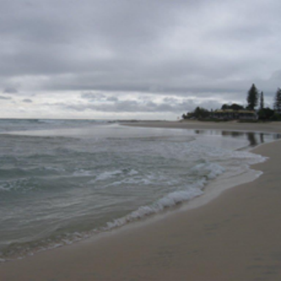
High tide.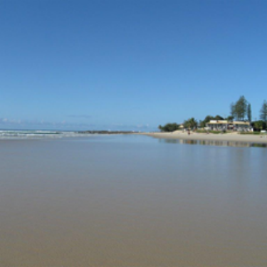
Low tide.
Here is a video filmed from the Greenmount Point lookout.
The swell is a clean glassy 1 metre and the wave period looks to be about 10 seconds.
Greenmount vid
Between the swells you can see the line at the edge of the white water which defines where the wave peeled. The depth under that line is the same for the length of the ride, in this case 2 metres.
The sand bypassing pumping system for the Tweed River is what makes the Superbank such a great wave. Whenever a big cyclone swell gouges out the sand it does not take long for the banks to be replenished by the pumped sand. Due to the south to north sand drift on our east coast, the sand that is pumped out at Froggies soon drifts into Snapper and then wave action, tide movement and currents move the sand into Rainbow Bay and on to Coolangatta then Kirra.
Here is a photo of the sand pump outlet at Froggies.
The sand pumping started in 2001.
The Superbank is now 10 years old.
Here is a link to a story by Tim Baker about the sand pumping system.
TimBakerstory
Part 3.
This photo was taken on Friday the 3rd of June 2011.
Shows 12 righthanders.
The surf report called it 3-5 ft with bigger sets.
Byron waverider bouy was reading 2 1/2 - 4 metres.
Period 10 - 13 seconds.
Swell direction between east and east south east.
The place was going off.
See the line of sight from this angle looks straight along the peel line.
Kirra groyne is behind the pine tree in the left of photo.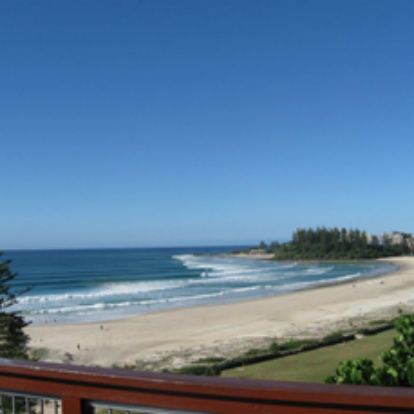
The next photo shows waves breaking wider on the biggest set, showing that the gradient gets more uneven in the deeper water.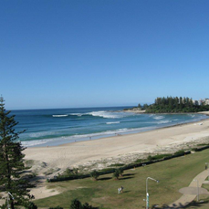
What are the qualities of the Superbank.
It has wind protection and works on southwest, south and southest directions.
Works on all swell directions because of offshore south swell refraction.
Noting that size decreases during refraction.
Long ride 1.2 kilometres when sand formation is right.
Open to long distance swells that come through the swell window between New Caledonia and New Zealand.
A fast makeable peel angle.
An even sloping gradient that drops at a rate of .66 metre over a length of 50 metres.
Warm water all year round.
Is it possible to build a man made surfing reef with all the qualities of the Super bank and more?
YES.
All the Superbank is is a 3 dimensional shape.
Find a place on our coastline that faces east and that has south swell refraction.
An east facing orientation would mean less size lost during south swell refraction.
Build a reef at the correct depth so that it works on the full range of tides.
Allow for a 2 metre tide range.
This would mean that a 75 metre width of the reefs gradient would be exposed above sea level on a zero low tide.
Therefore on a 2 metre king tide the shallowest length of the reef would be 1 metre under water allowing a 1/2 metre wave to break and peel.
Build a reef out of something solid that would be erosion resistant but copy the smooth gently sloping gradients that are the characteristic of sand bottom points.
How many times do surfers see quality sand banks ruined by big swells.
Extend the gradient deeper to 6 metres so that 3 metre waves peel along the reef the same shape as 1/2 metre waves.
The size of the reef.
1.2 kilometres by 500 metres is the size a reef needs to be to break on a size range from 1/2 metre to 3 metres.
Here is another slightly blury diagram.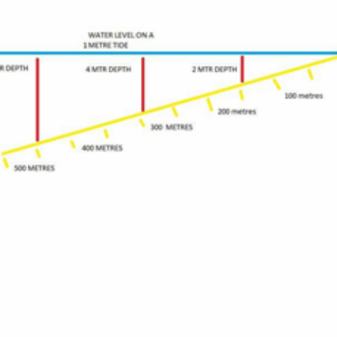
The red lines lines show that a 1 metre wave peel line would be over the 2 metre depth mark when the tide height is at 1 metre.
A 2 metre wave peel line over a 4 metre depth.
A 3 metre wave peel line over a 6 metre depth.
The yellow interval lines show the rate of slope .66 metre over 50 metres.
Is there anywhere on the east coast where a Superduper bank can be built or some where half a Superduperbank can be built.
The only way to find is to look at the whole east coast using google earth, one area of coastline at a time.
Philos.
Unfortunately my knowledge of East Coast geography isn't quite up to scratch, but I think you've got a really good idea here, and I can see your argument clearly. Thanks for all your work thats gone into this and I hope something might come of these ideas one day!
Now a prerequisite of that might be to work out the benefits of such a project.
(other than for surfers)
You can be sure that the money will be very diligent is knowing what returns there will be.
A good start might be to find some indicators of commercial activity in all sectors before and after supabank on the Goldi -for as long as they exist.

Philo....ing-
Re -Superbank observations.
Good work, honestly, you have obviously been thinking about this for a while.
I think the key to making an AR economically viable is to minimise the size/cost and maximise the results. If you look at other reefs the same as you have looked at the S bank, you will find that the bottom profiles are substantially steeper, and using steeper profiles makes a reef smaller/less expensive. Also if you detach the reef structure from the headland and move it out up the beach you can get a break off each side of the structure, your classic a-frame type break, again making a more compact reef proportional to the total ride lengths created. Also, you then remove any potential disturbance to the natural headland area. You also have to make AR's suitable for commonly found situations, ideally a protected sand bottom embayment that gets good swell, but any open sand bottom beach would be ok, and there are plenty of these. The AR can then be a profitable commercially available prefab product, suitable (with custom design) for many situations.
Keep up the analytical thinking, and I predict you will come to what I'm proposing.
Steve and Phil,
one flaw in the thinking for putting solid features onto sand is the uncertainty of the mobility of sand.
No amount of modelling or perceived expertise will be able to know what will happen and when it will happen. sand particles
operate in 3d by the effect of moving water and then there is a fourth dimension -time. The variables that cause this are many, complex , interacting important things like wind, wave, size,direction, tide, water temperature, geomorphologic and sometimes erratic , unforeseeable and with millions of permutations and combinations..
The best one can know is that sometimes what is intended may happen sometimes.
Why? Because of the shifting "storm bar" This is where sand ends up after the amount of energy hitting the shore is rebounded and transported the sand as far out as it can. I believe its called the "depth of closure " for that wave regime. its a result of a "steady state" or equilibrium regime ( in energy in towards the beach -sand transport out with the rebound, backwash and rips with mobilised sand out until velocity dissipation and sand is deposited.
It changes hour by hour or even each large set. But most importantly its always moving -into the beach in small waves and out from the beach in larger conditions.
I believe a major cause of the changes to the Mt Manganui reef was its overwhelming by the changing sand storm bar . This was due to an unexpected larger than usual el nino event. ( I will take advise on that if it is not correct). I also believe that the initial covering of the Narrowneck reef was due to the bags being placed over the storm bar ( a cost decision to not "box" or bed level b4 bag laying). When the storm bar adjusted the surface of the bags did so as well. Thus the top initial levels where lowered by that adjustment. ( I think a bed levelling exercise may have been done on the Bournemouth reef as it was meant to provide surfing excellence straight away)
Then we have the so called "zeta " beach behaviour (because the Greek letter zeta resembles form above the shoreline shape of hollow and hill with corresponding sand banks and rips thus outside storm bar. these zeta shapes travel along the beach with the swell direction and can move heaps of metres a day.
In some circumstances this will have more certainty than others. especially when all is naturally "set up" by millions of years to be in equilibrium ( the supa bank before the tweed training walls and after sand bypass)
To totally duplicate that in a certain and predictable way will be very difficult on sand . ( unless there is one without sand and we start sand pumping.
An artificial submerged structure on sandy beaches will, I think be very elusive as a successful surfing location for a long time yet, But I wish anyone luck with it as all efforts are progress . (even failed ones as they show what not to do and how not to go about it).
But I have to question the basis of
"You also have to make AR's suitable for commonly found situations, ideally a protected sand bottom embayment that gets good swell, but any open sand bottom beach would be ok, and there are plenty of these. The AR can then be a profitable commercially available prefab product, suitable (with custom design) for many situations."
That I feel ,from my little knowledge is fraught with uncertainty and thus sustainable success.
There is nothing wrong with examining such things , in fact totally correct in doing so.
The difficulty arises when one is totally besotted with the strengths and opportunities , we can subliminally ignore the realities of the weakness's and threats.
Thus the unintended (and sometimes ignored initially) consequences become the hallmark of another less than outstanding venture.
In the ocean even the most heavily engineered and without limit funded ventures fail and do so quite often. Sometimes with the most knowledgeable,capable and skilled designers. Its the ocean and nature -that's what it does and will always do.
bob_s
The reality is that engineering has moved on on a little since we were encouraged to "build upon the rock not upon on the sand". For every foundation material, in every situation, there is an accepted engineering solution.
As an example, take say the Gold Coast sand pumping jetties.. steel structures built in sand in the surf zone and engineered to stay put in the worst cyclonic conditions. A steel reef structure would be no more difficult to engineer.
yes I agree the foundations there are well below the expected level of disruption by any circumstances.
Pier structures are nothing new at all in the marine environment or for structures on land that are in danger of being undermined from the side. They are simple standard operating practice for sustainable structures in difficult environments.
That has been well known and many extreme things built over many years -bridge caissons etc.
You are confusing support conditions for the uncertainty of the surrounding topography. Its like having a robust well supported building in the middle of travelling sand dunes that I am talking about. Newcastle beach sand dunes started to overwhelm buildings in east Newcastle at one time - travelling sand is a problem on land or under water. Its only sand. You can of course build on it - but you cant ever fully control the environment that controls it.
Any successful business model requires full control over its operating environment. Otherwise it has risks and vulnerabilities.
When a storm bar passes over and back again over a submerged structure is the difficulty?
The effect of that is what is seen on Narrowneck and on the Mt Reef.
yes bags slumped as well on both and your solution does not have that weakness.
Yes you can have it adjust to the height of the tide and either sand around loss or accretion.
That is another level of complexity to counter that vulnerability to certainty of quality and quantity delivery..
Of course nothing is impossible its just that the cost vs benefit suffers.
Fixed structures main Vulnerability is not their support or shape -its that everything around is in constant
motion and that motion is largely uncertain and not fully indeterminate.
Its the ocean and sand in it -that means a constant state of flux. That sand, I read was original the Blue mountains , then sandy beaches at the continental shelf. Sea level rose and it was pushed up to our beaches. The east current circulation system takes it up to past Fraser island to fall back into deep water again . That is the Macro scale, the micro scale is another matter but the large changes that caused and power the macro are still operating in the micro scale every now and then to totally overwhelm it.
Regardless building on the rock will mean that there is less chance of it being overwhelmed by the sand.
Even my favourite place Crescent head gets sand in the wrong places at the wrong times.
Rock surfaces in the ocean are more certain than sand - but even good rocky points are vulnerable.
Perhaps suction is the engineering solution.
As soon as I saw the legs on Steves steel "A'' frame reef design, a documentary I once saw about the Troll gas platform came to mind.
Here is the link to part 4 of 5.
trollgas platform
Parts 1,2,3 and 5 are worth checking out as well.
Regarding building on sand.
I wonder how the people who built the rivermouth groynes using large boulders dealt with the issue of sinking.
Is there some formula for wet sand compression, whereby the heavy rocky groyne stops sinking.
I wonder if there is any documented history on how the groynes were built and the problems encountered.
phil. there is no such thing as "suction" , its actually air pressure the same as water pressure. Higher pressure "forces" what one thinks is being sucked . Its like saying the loser in arm wrestling is "sucking" the winners arm across - we all know the stronger arm wins and that is the same with what we think is suction. ( unless the stronger is "throwing the match?)
We induce a low pressure zone ( weak arm) high pressure zone (strong arm) will always go to the low pressure zone (if the person is trying) . Its the same for wind, water and earth. Thats why air moves from high pressure zone to a low pressure zone. Thats called wind in weather patterns. Sorry suction doesn't exist except when we lose and we say "that sucks". if its not mechanically powered then gravity will always "push" not the destination suck. Water at a higher level will be forced by gravity to a lower level -not the lower level sucking it. But in hydraulics I think suction pressure is used as the term to define the difference in forcing pressure to the area that is receiving the fluid.
I found this.
"The terms suction and discharge are the terms refer to hydraulics. In hydraulics if the the liquid has to be lifted or pumped to the usage area the hydraulic pump will be used . This pump will have to functions that is first suction to lift the fluid and the discharge or delivery . The familiar words in pair are lift and discharge; suction and discharge. The specification of pump for these terms are suction head and discharge head.
Piers: piers for anything will if supported to a stable non-threatened strong enough foundation be "sufficient" How large how deep and how strong of all parts of the system is important to be "sufficient".
Good question about rock on sand -the answer is continual "topping up" as the rocks keep going down and spreading due to the nature of the unstable nature of ocean sand. Eventually of course the amount of "topping up" slows ; throw enough rocks into the ocean and they end up forming a layer that locks together and is supported deep enough where wave action etc. has limited effect. Like building a road over a swamp eventually some form of stability will happen - heaps of rocks needed though!. the traffic will keep it sinking. The latest clever deal for roads over swamp is closely spaced deep bored holes filled with rock and geotextile over these rock piers covered by more rocks for the expressway around ballina.
Bob,
What about the example of suction created by a vacuum in the video I posted.
The demonstation that Richard Hammond gives at 4 mins 50 sec into the vid has the potential to be the way that surfing reefs are anchored to the seabed floor.
Phil.
remembering that the term "suction" is actually creating a zone of low pressure. If its a piston in a cylinder and the piston goes down and no openings are anywhere - then a zone of low pressure is created. What was there occupies a greater volume , the amount of air molecules is the same but the volume it occupies is maybe 5 times (say) than before. For normal air pressure there is an absence of enough air? We "stretched " in 3d the air that was there? Now if we open a valve at the top -air rushes in. It is normal pressure air flowing to a zone that has a void (less air for the same space) that is higher pressure to lower pressure to equalise. The suction part is actually reducing the air pressure by increasing the volume that a small amount of air can occupy -mechanically.
That can also be done with a tin can - (not any flammables here) . Put a little hot water into a tin can shake it about a bit and empty -then quickly screw the cap on. Put cold water onto the can and watch the can collapse due to the warm air and steam in the can cooling - occupying less volume thus at a lower pressure for the same amount of matter. The outside air pressure crushes the can.
Serious can crushing spectacle
yes absence of air and water can cause serious forces to come into play entertaining , useful or damaging.
Yabbi pumps are a similar thing?
Screw piles and using Yabbi pump method tubes as foundations work well and I don't for a moment think that the foundations for Steve's reef cannot be engineered to be sufficient for reasonably expected circumstances.
bob_s, Phil...ing -
Re- stability of a steel reef structure
Bob- I assume you accept that piering will form a stable structure, as it has for the GC jetties, in the case of the jetties the piers are emergent and support an aerial structure, in the case of my reef the piers (screw piles are the preferred piling system) will support the submerged structure sitting on the seabed, and also prevent uplift. Caissons beneath the reef structure and a perimeter vertical skirt will penetrate the seabed (like a giant cookie cutter) to assist in lateral stability. The reef will be filled with sand to provide additional mass/stability. Seabed levels in the offshore zone may be quite stable, or may fluctuate +- up to a couple of metres, depending on the location/storm cycles etc, so if deemed necessary for a particular situation, anti-scour matting may be installed to the perimeter of the reef to prevent undermining/ destabilisation of the footing system, should the seabed level become lower. Higher seabed levels are not a problem. This is all standard offshore enginering technique, see the engineering concept diagram on my website- www.offshoresurfreefs.com
Phil-The "legs" on the model you refer to were the screw piles.
Here is an easy way to turn inactive links into active links.
Click the edit button and up comes the origional post you typed.
In front of the inactive URL type
Then at the end of the URL type ">
Then any words describing the link (this turns blue once submitted and is the bit that can be clicked on)
Then type
Thats it.
Steve you mention the reef will be filled with sand to provide additional mass/stability.
What is the reason behind this and why not just fill with water.
thanks Phil - I've always been fascinated by that but preoccupied to learn how.
Good luck with that Steve. After all the works that have been built in the sea the sea always wins.
That's what it does.The uncertainty is as bad as any can be -even for very large boats let alone fixed structures.
How far off the beach would you install your reef so that you can think that the perpetually shifting storm bar "will not be a problem"?

Superbank.
Philo - you provided a fantastic and extensive description of the Superbank, with good local input. To my understanding Neil Lazarow, Rabbitt and Andrew Mckinnon feel there is toooo much sand getting piped, infiling the Coolangatta Bay.
Philo - my question is - do you have any thoughts for how to do it better? Or do your think the sand bypasssing system is working fine just as it is, no tweaking required. Given the existing pipeline outlets and the annual quantity of sand - how would you do it? Any preferences for prefered discharge outlets? Any preferences for timing? Any preferences for - piping heaps of sand infrequently, v's shifting smaller amounts more fequently? Of interest...
Phil-
Sand fill is denser/heavier than water. A water filled container doesn't have that much more mass than the water it is submerged in. Take a drink can for example and fill it with water, it feels quite heavy out of the water, but submerge it and it will almost float around, the same for a steel reef filled with water- not enough mass.
Bob-
I disagree with your assertion that structures cannot be engineered to be stable in the ocean. I have given you the example of the GC jetties, and another example is the GC desal inlet/oulet structures at Tugan. All these steel structures are still sitting exactly where they were designed by engineers to stay.
For vid of the desal structures see http://www.watersecure.com.au/what-we-do/underwater-footage
The typical distance offshore for a reef would be about 250-350m, and btw I said that rises in seabed levels would not be a problem, and that a lowering of the seabed levels would be a problem that could be countered by installation of anti-scour matting to the perimeter of the reef structure if deemed necessary.
I guess you will have to agree to disagree with my and other engineers.
Steve, you are completely misunderstanding what I am saying and its my fault for not being clearer in my writing.
I can understand if you are feeling a bit defensive and if I have made you feel that way I am sorry.
What I am saying that the nature of the ocean is such that we don't know when a 1 in 1000 year event may happen , we only can assume that it wont , if we don't want to design for it. .
Then there is the uncertainty sequence of multiple events one after the other.
Its obvious and sop that things can be engineered (at proportional cost) to suffice under a chosen factor of safety.
Not a great rise in wave climate and circumstances can mean doubling of cost for robustness in some instances.
There will always be a rogue event that holds us to task on that. ( as there always has)
To be a sustainable project a "sinking fund " may be established somehow to cover maintenance or replacement if and when it is necessary.
You will find to be without risk any project in hazardous circumstances will have an astute manager allow for that.
Why? for continuity of service if something occurs.
That's why no-one ever relies on one computer for all their records and business certainty.
Data integrity is a risky business and a expensive one to maintain.
The ocean is a bad place to assume perpetuity - anything that can go wrong will go wrong ( as we have seen over and over again)
That is why its so expensive a place to build things that last - that is indisputable. I don't for a moment think that your reef cannot be engineered to do its task. The surrounding shifting sand is another thing. If sand level due to shifting sand rise I think it will be a problem -why ? because the reef will not function as it should in creating good shape waves. Granted that may be small risk but as the Mount Maunganui designers and builders found (they know the ocean very well) the storm bar shifted and overwhelmed the reef. ( I believe due to a larger than normal E-Nino event.). that's where I am coming from and mentioned very early in my question.
Even then as we see in the gulf oil spill the worst can happen.
I am not questioning the stability or robustness of your reef at all. because as you say that can be catered for by design and that I entirely agree with. But for what factor of safety in what circumstances for what cost is another thing again as i am sure you will discover when you do your what if's?
So are you saying that a storm bar cannot be formed 250-300m out?
That is exactly the question that I have, not anything to do with the design otherwise. Sorry I should have been clearer .
It concerns the variability of the storm bar on sandy beaches -where the sand goes from sand dunes to storm bar and back again continually. (but with S---> North transport on the east coast.)
Some sand dune systems have as much sand as the ocean wants to take when it does- that is indisputable.
When and how often it can happen and where is the question?
So in saying that wont be a problem I assume that you will avoid those locations?
Or build further out than will be possible to be effected?
I am assuming that you are going public this way to discuss these things?
oh
Phil there is also another factor at play for a container filled with water. There will be a buoyant force that makes it lighter than if it were out of water. The mass of steel added to the mass of contained water must be used to get a average density.
you can calculate the buoyant force for any object by putting values in the table and pressing enter.
A heavier than water fill solution is needed in part to counter to buoyant force on the reef.
If you make the average density say 1.3 (saying the steel only adds 30% to the mass of water volume.) The amazing thing is the weight of that container is reduced by the buoyant force of 4.91N (newtons are a measure of force) when it weights only 5.89N. That is its effective "weight" has been reduced to .98N from 5.89N.
Filling that container with sand might give a new average density of 2.5 then out of water it weights 12.26N but immersed it will weigh 7.36N or 40% less than out of water.
I just hope that all the sandbag reefs took Archimedes principle into account for stability calculations and their inertia or "weight". if they didn't then that might be one reason for the lack-lustre success? Actually I just did a search for the actual density of saturated sand and came up with 1.92 so then plugging that into the density (thats 1.92 x water) .The geotextile container of wet sand then weights 9.42N out of water -lowering into water reduces the weight by half -that's for sand bags -they weigh half as much under water than above water so calling it a 10t sandbag above water means its only a 5t sandbag underwater depending on the height. wow?
I wonder if any of the sandbag reef builders can comment on that buoyant force being used in stability calculations??
I hope they did?
But for a steel container the average density will be larger because steel is about 8 times heavier than water. But its only a shell and framework?
here is a good question for you Steve, for a sample hypothetical steel reef
1. what is its steel weight for a given no.2
2.what is its inside volume for that weight?.
we can then calculate the out of water weight of the reef and its submerged weight.
or alternatively and easier will be to know the volume of the reef
"Any object, wholly or partially immersed in a fluid, is buoyed up by a force equal to the weight of the fluid displaced by the object.
– Archimedes of Syracuse"
100 solid cubic meters of sand in the steel will have 100 tonnes of uplift flotation. yet 100cum of solid sand will weight 190 tonnes out of water and about 90 to 100 tonnes in water. That's serious weight loss?
Importantly the greater the mass of the reef the greater is its inertia or ability to stay stationary ( or keep moving.).
or
Its why first gear is needed to get a car mobile as its stationary inertia is large.
Also why its hard to stop a fast heavy object because its Momentum is large.
A very large, dense,integral and robust mass in the ocean wont be effected as much by anything that can effect it.
But saying that , there is an example of a destroyer overseas that after sinking as an artificial reef in deep water broke in three separated heaps after a large seas event. we can never say never? The weight under water can be significantly reduced thus so is its inertia??
(BTW I wasn't meaning to questioning your analyse&design for your chosen circumstances at all -just trying to understand the sand shifting circumstances that your reef is designed for)
@phil . I'm humming with the URL links now . thank very much for that.
Bob-
Re -shifting sand engulfing a reef
Seabed levels at about 300m out will fluctuate +/- up to a couple of metres depending on the site (some locations may not change much at all) and storm cycles (storms take sand out and milder wave conditions push sand back in again). In rough figures, a reef about 250-350m out in normal conditions will be in water about 5-7m deep assuming a 1:50 slope out (standard figure used for East Coast Aus). Assuming a reef is installed in a very active location in terms of sand movement, at the median seabed level in the "storm cycle", and a storm occurs which takes sand out to the reef location and raises the whole seabed level by say 2m, the reef will still be in water 3-5m deep, and this would be temporary. This would not affect the operation, or stability of the reef.
Steve , that sounds good. You will have to forgive me for playing the devils advocate.
I know what its like to be on a mission and have people question everything . One feels is they are just being negative or counter productive.
I certainly don't mean to be anything other than pointing out perceived weakness's and threats .
If I perceive them many others will as well.
Have you engaged with the Old Bar community, as they are on a mission to build a reef?
They also want it built right now.
Their greatest opponent at the moment in their eyes is the cost that Worley Parsons is assessing a reef to be.
I quote
"At last the public exhibition of the Worley Parsons Management study has been completed. Our group is extremely disappointed with their costing for the "off-shore reef" which is far in excess of the figures we have seen for other reefs. We are doing our own investigations looking for detailed and accurate costings and to understand how the difference can be so great. "
the rest of the progress report is
I know Elaine Pierce and have contacted her recently advising of this forum . Also after the last symposium sent her details on your product. I hope that you are providing feasibility costs to her as if there will ever be a good chance it will be there.
Then onwards to the rest of the "hotspots' identified
So its all now up to you and the best of British luck to you! :)
Andrew,
Not sure about too much infilling along the Coolangatta beach area.
I surfed the superbank on that quality, clean ,long lined east southeast swell on the 3rd of June. Surfers were getting rides up to 3/4 the length of the superbank. The wave quality was incredible, so fast.
I would give the current banks an 8 1/2 out of 10.
I think the issue Neil Lazarow, Rabbit and Andrew Mckinnon have is the "bring back Kirra agenda'(for those that don't know the origional Kirra banks are buried under tons of sand due to too much sand pumping and the wave is a closeout), a good thing if it spreads the crowd, but a bad thing if less pumping reduces the wave quality at the superbank.
It seems like the best solution would be to start removing sand from an area just north of Kirra where the second groyne was and hopefully create a wave with a surfable peel angle. A future source of sand infill for Steves reefs perhaps.
It would be interesting to hear what sort of input regarding the sand pumping Neil Lazarow, Rabbit and Andrew Mckinnon have had, and what they have learned during the 10 year history of the superbank.
They seem to be doing a fine job so far.
Phil.
Steve,
after your mention of anti-scour matting I did a bit of a search and the results are HERE.
In particularCLICK HERE was interesting.
The words
"Erosion control mats are designed to work with nature in the building of fiber-reinforced underwater berms. Such berms reduce the impact of wave energy, thereby allowing a natural renourishment of beach sand from transported material. In coastal applications, the mats provide two actions:
The berm builds up and slows down wave action, diminishing erosion.
The slower wave action slows the sand in the waves and causes it to be deposited on the beach side of the berm - eventually rebuilding the beach."
attracted my attention as a way of building a "claytons reef". - which the sea builds for you?
The main threat might be the plastic as it looks like shredded plastic bags?
I don't think you would like the idea of leaving your reef out and only using the antiscour as a way of sand accumulating and staying as a "bombora" though?
Here is some information for any one interested in the Troll gas rig and has not checked it on youtube.
The doco is on sbs television on saturday the 9th of July 2011 at 7.30.
Richard Hammonds Engineering connections -Super Rig, the largest object ever moved across the surface of the earth by man.
There are 3 aspects relevant to surfing reefs.
How they moved it.
How they anchored it to the seabed floor.
How they made reinforced concrete.
Here are some photos of the rig being towed by tugboats.
how manmade surf reefs could be built on land and towed into position
Part One.
If surfing is ever going to evolve then we as a surfing tribe need to come together and collaborate on the design and building of surfing reefs.
This forum has created the opportunity for our minds to meet and create.
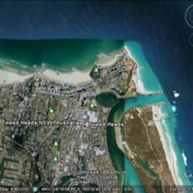
The first step forward is to look at the big picture, in this case the southeast Queensland and New South Wales coastline, and get an understanding of the characteristics and qualities of already existing surfbreaks.
A good starting point is the Superbank on the southern end of Queenslands Gold Coast.
Standing at the lookout at Kirra you get a panoramic view of the Superbank, I remember one time counting 17 righthanders between the take off at Snapper Rocks and the Kirra groyne.
Here are two aerial photos from google earth.
 photo[/img]
 photo[/img]
Looking from left to right.
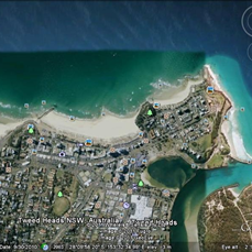
At the left Kirra, Kirra groyne, Coolangatta beach, Greenmount Point, Rainbow Bay, Snapper Rocks (these all face northeast) then facing east is Froggies where the sand pumping outlet pipe is, then Duranbah Beach, then the Tweed River.
Just south of the river is the sand pumping uptake jetty which you can see in the following photo.
When the sand banks at the Superbank are perfectly aligned surfers have ridden waves a distance of 1.2 kilometres, taking off at Snapper Rocks and pulling off just before the rocky groyne at Kirra. There have also been reports of longer rides on rare bigger swells where surfers have rode waves that have gone past the Kirra groyne and peeled across the Kirra bank.
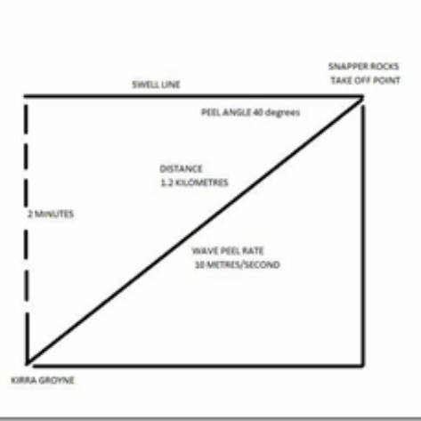
How many seconds is a surfer on a wave that peels for 1.2 kilometres?
 photo[/img]
Standing at the Kirra lookout I timed a ride and it took 2 minutes.
From these 2 numbers, distance and time you can work out the wave peel rate.
1.2 k's in 2 minutes
equals .6 k in one minute
equals 36 kilometres per hour
equals 10 metres per second.
With a map and a protractor I worked out that the peel angle for the Superbank wave is 40 degrees.
Here is a diagram.
Here is a youtube video by Pademauge showing roughly the 2nd half of the Superbank ride across the Coolangatta beach section.
Note the time 1 minute and 3 seconds.
This wave is peeling fast at a 40 degree peel angle to the swell line, at 37 seconds the second surfer paddles in and is travelling at a speed of 10 metres per second, then at 45 seconds the wave peel rate increases and the surfer gets barrelled, then the wave peel speed decreases back to 10 metres per second and the surfer comes out of the barrell.
supercoolyvid
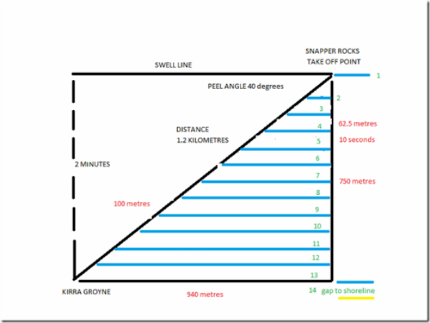
Next I took the 'wave peel angle time diagram' and projected a 10 second period swell onto it.
 photo[/img]
The following diagram shows 13 righthanders 10 seconds apart (the blue lines).
The diagonal line measures 1200 metres, the bottom leg of the triangle measures 940 metres and the side leg 750 metres.
Simple geometry.
This means that to create a wave that peels for 1.2 kilometres at a peel angle of 40 degrees you would need 950 metres of beach front and a headland or rocky groyne that sticks out 750 metres.
The diagram also tells us that the distance travelled by a surfer along a 40 degree peel angle in 10 seconds is 100 metres.
Also that the speed of a swell travelling toward shore, 750 metres in 120 seconds, is 22.5 kph.
And lastly it tells us that the gap between 10 second period swells is 62.5 metres.
A really important aspect to consider when designing surfing reefs is '' Is it possible for a surfing reef to work on all swell directions'' ?
The Superbank tells us this is possible.
The Superbank faces North east.
On east and northeast swells the swell lines hit the banks at 40 degrees and peel.
The massive offshore sand build up out off the Snapper Rocks, Duranbah, Tweed River and the next beach south causes south east and south swell to refract onto the Superbank.
Of course at a diminished size but the waves still peel for a good distance.
On a southeast swell you notice the waves are smaller the futher you go towards Kirra.
A typical south swell scenario, Duranbah 6ft, Snapper 3ft, Rainbow 2ft, Coolangatta 1ft and Kirra 1/2ft.
So a key aspect/ingredient to look for when designing right hand point surfing reefs is selecting an area where 'South Swell Refraction' is happening.
The main places on Australias east coast where this occurs are rivermouths where there is an offshore sand build up. Therefore just to the north are good locations to build reefs.
Buiding reefs where "South swell Refraction'' occurs means more quality surfing days per year.
The Super bank shows us this.
Philo.