Summer

I'd vote that November the worst I've ever seen

When the best surf session for a month was the body surf this morning - 1.5ft glassy low tide A frame - And that was not remarkable by any stretch
You know November was bad

November can be pretty shitty in South Oz. But apart from the week of the K.I pro event(it was flat), it was one of the best Novembers I have seen, without the constant S.E winds we usually get and some good swells! Im spending most of December on the Gold Coast so I am hoping the surf drought ends up there too!

A cold and gloomy start to summer here in Sydney. Here's hoping for a couple of decent NE swells.

I'm heading to Mr Mulletdumpling's territory tomorrow (Friday). If I see ya, I'll sing out!!! ;)
I see the long range EC charts are aligning somewhat with what the ACCESS G charts have been progging for the last few days now!!!
Looking like a possible ECL on Thursday or Friday?

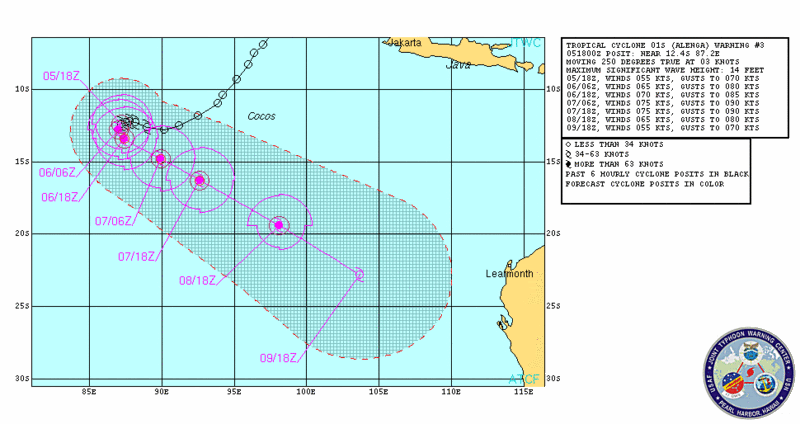
While not particularly impressive, the first Tropical Cyclone of the season is expected to move into Australian waters, way west of Exmouth over the next few days.
Tropical Cyclone Alenga is currently a Category 2 system, some 3,000km's west-northwest of Exmouth. It is expected to reach Cat 3 while moving within 2,500km's of the coast but then will weaken significantly while moving closer to WA (as shown below). Therefore the swell from Alenga is only expected to be minimal for the whole WA coast.
As you guys say long rage GFS isn't that great, still 16 days out from the last weeks swell showed something around those date.. but long range at the moment is looking pretty intense, no doubt by the next run it will have completely changed once again, at least its promising :D
EDIT: and there it is changed owell, plenty of time to go..
EDIT2: well looks like most of the models are going for some sort of low to form in the coral sea later this week :) hopefully that means a nice Christmas pressy from Huey. Winds don't look that great though. I might be wrong
A pretty impressive monsoon trough stretching from the Indian Ocean, across the top end and out into the Coral Sea is looking the goods for later this week. Could well have 3 cyclones surrounding the country, but the one to watch for us is the one progged out near New Cal, cradled by a semi stationary high pressure system. Doesn't get much better a setup than this!!!!
Biggest question now though is, will it come to fruition with such an active monsoon trough, one would think the models are seriously struggling to predict where and whent hese lows will spin up?
I'm sure the models will chop and change and the position of the low will be revised but whatever happens the broadscale pattern =SURF.
Decemeber has been pumping. Talk about flicking the switch.
Tropical Cyclone 3-day outlook for The Coral Sea
Issued at 1:45pm EST on Monday the 19th of December 2011 and valid until end of
Thursday
Existing Cyclones in the Eastern Region:
Nil.
Potential Cyclones:
A low situated southeast of Papua New Guinea is moving in a south-southwesterly
direction and is expected to develop further over the next couple of days. The
low is expected to remain offshore and not affect the Queensland coast.
Likelihood of a tropical cyclone in the Eastern Region on:
Tuesday: Low
Wednesday:High
Thursday: High
Latest GFS charts are looking just down right NASTY!!!! :)
Hope this won't be a Jetski only swell and that the sweeps are not out of control :( good timing for a Christmas week off though :D
Looking very solid into early next week across most of the East Coast!! I'll be in SA :/
That GFS forecast just keeps on looking better and better!!! Don't want ACCESSG at all, and EC would do me just fine (noting likely to be smaller than GFS).
Don, I know I've been banging on about the similarity of this Nina build-up to 2008 but it's uncanny how this upcoming system bears to the one between Xmas and NYE in 2008.
Likely to to become a named TC sometime today or tonight.
TC Fina I believe.
Hopefully on Monday the new incoming high from the west pushes through quicker than anticipated to keep this thing going.
Steve, I reckon you'll struggle to paddle out on the open beaches with this swell and an 8fter, particularly on Sunday/Monday due to the progged close proximity of the head of the fetch, delivering a pretty relentless supply of swell. Protected points will be one's only real option to make it out no jetski assist IMO if this ETT comes off as currently progged.
There's plenty of points that will hold this easily Don.
And a secret rivermouth if it gets giant.
And I think this system might end up a tad further off the coast than some models have suggested.
And I think this system might end up a tad further off the coast than some models have suggested.
By: "freeride76"
Still thinking this Steve?
Nope. But just far enough that we should be away from winds stronger than 20/30knots.
Heading back to South Oz today after a mad month of surf on the Gold Coast. I want to thank Father Huey for delivering some aquatic christmas presents I wont soon forget!! Hopefully summer in S.A will keep the ball rolling with some nice beach/reef stuff on offer.
R.I.P Sean Collins. The guy was responsible for us all getting more waves than we will ever realise!
yorkessurfer hahah dont get to excited unless its for pondie. its been constant strong sou-easterly down here and will stay that way for a while
Yep top crissy, just got back from balina and the northn beaches, scored some crack a jack waves. Missus loved it and to top it off, Australia spanked India in the boxing day test. Things just go from good to bettter! Happy New Year!!
Yep top crissy, just got back from balina and the northn beaches, scored some crack a jack waves. Missus loved it and to top it off, Australia spanked India in the boxing day test. Things just go from good to bettter! Happy New Year!!
By: "timberskills"
all ya need is a root and its a perfect day
Could be a rather wet week coming up on the east, west and top end coasts with an impressive active monsoon trough potentially on the cards. Models, particularly GFS are struggling big time to reign this one in.
Yeah, hope we don't get a flood.
I'm loving the warm, blue water.
Been a pretty consistent summer so far though. No complaints.
Ive been stuck in surfless Adelaide for most of the last 3 weeks housesitting while my folks have been in Ethiopia.
Last week 5 westerners were shot dead, 4 kidnapped then a bus crash killed dozens including an Australian.
Mum runs a charity that is building medical clinics, schools and shelters that look after 6000 homeless kids over there. Shes a champ but my nerves are shot from all this drama.
They get home tomorrow and I am off home to Yorkes in time for a new swell on Wednesday. Cant wait!
Yeah, hope we don't get a flood.
By: "freeride76"
Some serious totals are forecast for the next week or so from both GFS and EC, Steve. Some of these totals are forecast for offshore, but it won't take much change in the models for these totals to fall over land........then all hell could break loose.
Quite ironic the weather bureau released statements last week saying we're not in for a wet summer now......I wondered if they looked at the latest long range models when they said this as they were hinting at some pimpressive rainfall totals even back then.
Time will tell I guess.

Don & Freeride .
Looks like most of the rainfall / Precip damage from this will be from Upper Low / Monsoon combining . Not so sure of any Surf for the next week in your Neck of the woods .
But this is looking to be a VERY Strong MJO burst , and all the Rain your getting will be when it's main strength will still be on the NW Aust , coastline ( Somewhere in the Pilbara looks to be in for a hiding ) .
But more importantly ( probably more on the Flooding than surf aspect ) , eventually the peak of the Monsoon Trough will come east into the Coral Sea / West Pacific [ Near Solomons ] . And in the typical cycle of things , you may see another Cross Equatorial flow . Meaning something similar to Yasi's formation . The only positive will be the Coral Sea ' SST's are alot less Potent . So maybe only Cat2 -3 . As for steering ??????
So quality ENE surf a while away .
It's got that feeling Southey.
and visually we've had some very impressive vertical development in the cumulus towers lately which always seems a prelude to a soaking.
Ants were going berzerk at my place late last week and all weekend so that usually signals were in for a soaking. We'll have waves up here Southey, just gotta sit it out and pounce on the window of opportunity when the winds swing favourably.
Well it seems the ants were right. There's been some very impressive rainfall totals both overnight and this morning in SE Qld. How's the northern rivers holding up Steve?
PLenty of rain, nothing too dramatic though.
Shame our lovely blue water is gone though.
Looking like the east coast could get some nice waves from next weekend onwards, not sure of the wind situation tho?
Some of the models are showing a low forming in the coral sea and being cradled by the high.. sound right or am I compltely off lol?
goldy,the maps still looking good for up the north coast and s.e. qld. winds do not look great,light onshore. seas not as large as the xmas swell but that low was also fed by 6m fetch from fiji.....thats how i predicted the 10 -12 ft , some said that was a mighty call [dan ross called sets at angourie 12ft on xmas day] if it stays the distance off the coast that the maps are showing...should be clean swell i think....long range 4-8ft...how can we get roger badham the yachting weather guru to analyse the weather maps for us surfers......
Yep, swell coming, just a question on the local winds now....which are still divergent(strength and direction) according to the models.
Won't be huge (I'd be thinking something in the inconsistent 4-5ft class this coming weekend, with the potential for upgrading if the tropical low retrogrades), but should be well spaced out and long period. Question is, what banks will be any good?
Well the retrograde looks a fair certainty now, so swells on the up chaps!!!!
yes donweather and with good winds what your prediction for size ?
Good winds? For the points I assume you mean....where every man and his dog will be there.
Based on latest retrograde and tracking of GFS (noting it's looking better for SE Qld compared with latest EC) I'd be thinking something in the inconsistent 6ft/6ft+ on Saturday, building to potentially 6-8ft on Sunday if GFS comes off, albeit these are at open beaches. Outer protected points probably another foot or so smaller, with inner sheltered points another couple of feet smaller, particularly on Sunday when the swell direction swings more E/SE.
I'm sure you guys will get Swell , but considering how active that Monsoon trough further nth will be as this MJO pass is forecast to truely ramp up in strength .
i wouldn't be trying to put actual figures to any forecast including exact dates , as I'm sure they'll be multiple LLCC 's that will intercat with each other within the next 1-2 weeks .
So Yes waves , but will probably be a Roller Coaster of swell peaks , and wouldn't tip a particular peak in conditions . Best to keep ya fingers on the Pulse each day , to catch the best conditions .
Yes retrograde is promising , but so is a " Dosie Do " of sorts with atleast two LLCC swinging around each other . So could be even a second Retrograde once they converge .
Summer is over. The snotty nosed little mites are going back to school and their stressed out parents have left the coast for their 9 to 5 lives. 3 cheers and fuck off. The next thing we have to look forward to is the 3 fin circus at Bells at Easter. And they can fuck off too.
Seems that Jasmine has intensified more then expected over the past few hours, wind gusts up to 235 km/h (Cat 4 now), just hope that it stalls below NC or at least some sort of high pressure ridge would form for it not to just slip to the ESE. Too much to hope for?
Yep , she's really hit her straps with Diurnal peak .
Could stall a little south of NC . but will probably not hold above a Cat 2 for long as SST's aren't that flash in the ideal swell window .
Total lack of a ridging High over NZ and Southern Tasman is your major issue . Hopefully it stalls and hangs in there as long as possible , very little in the way of Retrograding , and a Possible short lived ECL and broad low in Extreme South Tasman will cause this unwavering
stall . So pray for the Eastern Dip in Southern NSW to wash out as soon as Possible .
lol, might want to update the swell forecast. Shes bombing, dropped from 958mb at 11am AEST to 927mb at 10.30pm. Its a mid/high CAT4 and might get to CAT5 if it keeps this up. GFS and UKMET both have it tracking south. GFS has it moving back north into the tropics a few days later as a warm cored low. EC model has it moving east then looping back over the north of Fiji and heading back west. Not sure of the intensity of the future runs of Jasmine but looks pretty wild. All we need is a high building to the south, which isnt forecast to happen unfortunately.
Should see a short lived pulse in the range of 4-6ft I would have thought, depending on speed and if it heads south.
Such a tiny system though.....latest ASCAT finally got a reading on it.
Moving SE across the great circle rays, super compact core with the fetch only just now coming into the swell window.
Fiji met continues with a weakening trend as it tracks into the swell window....
I dunno....if it started to retrograde towards us then I might get excited.
And I reckon GFS has been on the wacky tobaccy with their continuing prediction for the system to move slowly S then loop back up to the NW.....EC seems much more plausible to me.
Hey Poncho I can't seem to access JTWC......do you have a working link?
JTWC seems to be up and down intermittently. Back up now.
Fiji met continues with a weakening trend as it tracks into the swell window....
By: "freeride76"
Can't say I'm impressed with their forecasts to date, Steve. They had it at a Cat 2 by now (in their forecasts a day or so ago) and she's currently bombing from Cat 4 as Poncho has said.
Definitely a very tough one to swell forecast given the such small compact fetch. If GFS comes off though, I reckon we're in for a very brief pulse (potentially occuring during the night) of something upwards of 4ft/4ft+.....but this all hinges on which way she swings this afternoon/tonight!!!
Yeah as Don said, Fiji met have been pretty average this season... They missed Cyril completely and it only got brought up on facebook by a corporate weather company based in fiji called Na Draki.
JTWC, RAMMB and manati have all been having issues it seems with either late updates, completely forgeting updates or site down issues. Vanuatu met have actually been pretty good, they had hourly text updates lastnight which was how I managed to track its pressure, apart from CIMSS sat comparrisons, but you sort of have to interpolate their results.
Vanuatu met have it dissapaiting as a tc by the 11th, which I think is a bit of a joke considering JTWC said it could be classed as a annular cyclone. These type of cyclones typically break down at a slower rate than a normal cyclone. With expected weakening in the realm of 12knts/day or 0.5Dt/24hours. I cant see it begining to weaken for atleast the next 24-48 hours with shear being so good, it may fluctuate its intensity with the diurnal but the only real thing that could kill it would be sea temps but they would have to be down at around high 24c for it to happen to this system.
EC are showing the same "trend" as GFS, UKMET have it going south and then cant decided, ACCESS couldnt hit the side of a barn with a baseball bat and for some reason the tracks JTWC and everyone else are following is that of NOGAPS and CMC??? With NOGAPS being the worst performing model next to ACCESS.
By: "craig"
Thought I'd start a new thread Craig.
Thank feck the month of November is behind us. One of the worst on record in SE Qld for no surf.
Looks like the drought is broken, and in more ways than one come late next week with the potential for some serious flooding rains for SE and S Qld!!!