Large surf developing, with a small window of clean conditions as it eases

Western Australia Surf Forecast by Craig Brokensha (issued Friday 19th October)
Best Days: Early tomorrow and Monday Perth and Mandurah, all locations Tuesday morning, Thursday morning
Recap
Poor waves across all coasts yesterday with a stormy increase in windswell and strong onshore winds, holding a similar size this morning with similar conditions.
Today’s Forecaster Notes are brought to you by Rip Curl
This weekend and next week (Oct 20 - 26)
There's been no change to the weekend's outlook with the swell dropping further into tomorrow morning along with stronger W/NW winds across the South West, though more than likely NE early across Perth and Mandurah.
There should be 2-3ft of swell still in Mandurah, with 2ft+ waves in Perth, worth getting an early in before winds go onshore later morning.
This strengthening W/NW breeze will be linked to a pre-frontal fetch of W/NW gales moving in from the south-east Indian Ocean, slipping south and under us tomorrow.
A new SW groundswell is due off this fetch, filling in Sunday and coming in at 6ft+ across the South West, 3ft in Mandurah and 2-3ft in Perth but with fresh W/NW tending W//SW winds.
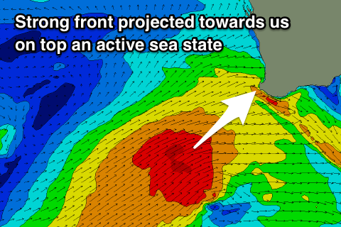 This change will be linked to a vigorous polar front projecting up and into us, on top an active sea state generated by a broad fetch of strong SW winds ahead of it.
We'll see SW gales projected in a capture fetch like motion into the south-west of the state before passing on through the Bight.
An oversized SW groundswell will be seen, kicking later in size Sunday but peaking Monday in the 10ft range across the South West, 3-4ft in Mandurah and 3ft in Perth but with fresh to strong SW winds, easing through the day.
There's still a chance for early S/SE winds across Perth and Mandurah as the swell starts to fill in.
Tuesday morning still looks like the best chance to surf with large easing surf from the 8ft range across the South West, 3ft in Mandurah and 2-3ft in Perth with an early E/NE breeze, swinging onshore earlier around Margs compared to further north.
The change will be linked to a weak mid-latitude low moving in from the west, with no real decent swell due to be generated in its wake, just onshore mid-period energy Wednesday, cleaner and easing Thursday.
Longer term there's nothing major on the cards until later next week when we may see polar storms generating a swell for next weekend, but more on this Monday. Have a great weekend!