Fun waves over the coming days before onshores hit

Western Australia Surf Forecast by Craig Brokensha (issued Monday 15th October)
Best Days: Early tomorrow Margs, most of morning Perth and Mandurah, Wednesday morning all locations
Recap
Small onshore waves across the South West Saturday, larger and messier Saturday with a building mix of groundswell and windswell.
Perth and Mandurah were small to tiny and onshore Saturday, larger and stormy yesterday as a mid-latitude front pushed into the coast.
This morning conditions were still average across the South West, cleaner but not ideal across Perth and Mandurah with weak onshore winds.
Today’s Forecaster Notes are brought to you by Rip Curl
This week and weekend (Oct 16 - 21)
We should see cleaner conditions across all locations tomorrow morning with a temporary low point in swell ahead of our new large long-period W/SW groundswell building into the afternoon.
The swell looks to be a touch smaller than forecast on Friday with the strong but slightly disjointed storm not being as ideally aimed through our swell window as it could be.
A pre-frontal fetch of severe-gale W/NW winds looked best, with a stronger but tighter fetch of storm-force W/SW winds around the core of a low, followed by strong to gale-force W/SW winds.
Size wise we're now looking at a strong pulse on size to 6-8ft, if not for the odd bigger one tomorrow afternoon/evening across the South West, with 2-3ft sets in Mandurah and 2ft+ in Perth.
 The easing trend looks slow with easing 6-8ft sets across the South West magnets Wednesday morning, 2-3ft in Mandurah and 2ft+ Perth.
Coming back to the expected winds and all locations should see a morning E/NE offshore tomorrow morning, N/NW across the South West into the afternoon with SW sea breezes to the north.
Wednesday morning looks super fun with an E/NE offshore again, giving into stronger onshore winds through the afternoon as a mid-latitude front pushes in from the west.
This first front will be relatively weak and generating a broad and elongated fetch of strong W/SW winds while projecting east towards us.
A moderate sized mid-period W/SW swell is due off the front, building Thursday and then easing Friday.
Size wise the South West should build to 5-6ft, 2-3ft in Mandurah and Perth but with gusty W/SW tending SW winds, easing from a similar size range Friday with persistent W/SW winds.
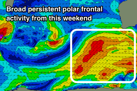
From the weekend a couple of stronger storms will develop south-west of us as a strong node of the Long Wave Trough forms and stalls across the Bight.
This will project non-stop polar and mid-latitude fronts up through our south western swell window generating large levels of groundswell but with onshore winds through the weekend, possibly improving mid-late week as the swell starts to ease.
We'll have a closer look at this on Wednesday though.
Comments
Best waves in a nautical mile. That is just beautiful. I wonder if anyone would notice if I snuck back to Car blew up? Maybe the bounty on my head has been lifted?