Larger surf developing late week, pumping Saturday

Western Australia Surf Forecast by Craig Brokensha (issued Wednesday 12th September)
Best Days: Protected spots Friday, Saturday, early Sunday Perth and Mandurah
Recap
A large onshore swell building across the South West yesterday, cleaner around Mandurah and to 3ft, though less so around Perth with variable and shifty winds from the south.
This morning is much better with the large swell seen into yesterday afternoon hanging in around Perth and Mandurah with light morning offshores, large and poor across the South West.
Today’s Forecaster Notes are brought to you by Rip Curl
This week and weekend (Sep 13 - 16)
Today's easing swell will be replaced by a new SW groundswell tomorrow, generated by an elongated fetch of W'ly gales through the south-east Indian Ocean the last couple of days.
Unfortunately another polar front approaching from the south-west will direct poor onshore W-W/SW winds across all locations.
Size wise the South West should see 8ft sets, with 3ft+ waves in Mandurah and 2-3ft surf in Perth.
Our larger SW groundswell for Friday is still on track, with the polar front approaching from the south-west expected to project a great fetch of severe-gale SW winds on top an active sea state up towards us tomorrow, clipping the state Friday morning.
An oversized SW groundswell is expected, building through Friday and more so into the mid-late afternoon, reaching 10-12ft by dark, peaking overnight and easing from the 10ft range Saturday morning.
Perth and Mandurah are only due to kick through the afternoon, likely to 3ft+ on the former and 4ft on the later, easing from 2-3ft and 3ft+ respectively Saturday morning.
Winds on Friday will be poor across the South West though good for protected spots with a fresh to strong S/SW breeze, tending S/SE later, with S/SE tending S/SW winds across Perth and Mandurah.
 Saturday is still the day to surf though with winds swinging offshore from the E/NE, variable into the afternoon across all locations.
Sunday then looks poor with another front approaching bringing W/SW tending S/SW winds across the South West, from the S/SE early further north but only small.
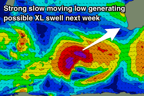
This front will be linked to a very strong though weakening low moving in under the country, but the earlier stages will see a great slow moving fetch of severe-gale to storm-force W/SW winds generated through our swell window.
An XL W/SW-SW groundswell is expected from this low, arriving later Sunday and peaking Monday to 12ft+ across the South West reefs, larger on the deep water reefs, 3-5ft in Mandurah and 3ft+ in Perth.
Winds look to be out of the S'th Monday and then more offshore Tuesday as the swell eases, but more on this Friday.
Comments
This is quite something..
Evil..Why would you.
God knows.
wow
That Kerby Brown fella knows how to charge
Insane!