Short window before winds swing back onshore

Western Australia Surf Forecast by Craig Brokensha (issued Friday 10th August)
Best Days: Saturday, early Sunday northerly wind friendly breaks, Wednesday and Thursday mornings Perth and Mandurah, Margs Friday
Recap
Large stormy waves across all coasts yesterday, but this morning's window of more favourable winds around Mandurah and Perth was seen creating clean good surf, with easing 3-4ft sets off Mandurah and 3ft in Perth. Margs remained generally poor and best in protected spots with a gusty S/SW wind (S/SE in some areas to the north).
Today’s Forecaster Notes are brought to you by Rip Curl
This weekend and next week (Aug 11 – 17)
Want to receive an email when these Forecaster Notes are updated? Then log in here and update your preferences.
While conditions improved across Mandurah and Perth this morning, we'll see all locations offering good clean waves tomorrow and with fun amounts of easing W/SW swell.
Our current W/SW groundswell is on the ease, but this will be slowed by some new mid-period W/SW energy from a relatively weak front pushing into us yesterday.
Margs should ease from 5-6ft on the sets, with 2-3ft waves in Mandurah and 2ft sets in Perth along with a light E/NE offshore wind, variable into the afternoon in all spots but Margs which will see a N'ly breeze.
 Come Sunday the swell will be much smaller and options limited with a possible dawn N/NE breeze around Margs, quickly shifting more N and then N/NW through the morning, with slightly better and longer lived NE winds around Perth and Mandurah. We're only looking at leftover 1-2ft sets but.
The strengthening N/NW wind will be linked to a strong mid-latitude frontal progression moving in from the south-west, with stronger N/NW winds expected on Monday as it nears closer, whipping up a junky NW windswell.
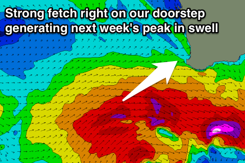
The front is due to pass Monday evening, but a strengthening trailing fetch of gale to severe-gale W//SW winds right on our doorstep will generate a new large SW groundswell building through Tuesday and peaking Wednesday.
Also in the mix on Tuesday will be a new long-range W/SW groundswell from the earlier stages of the mid-latitude frontal progression south-east of Madagascar.
This swell will be mixed under the building windswell and groundswell Tuesday along with strong W/SW winds.
Size wise we should see a peak on Wednesday morning to 8-10ft across the South West, 3ft in Mandurah and 2-3ft in Perth but with lingering onshore winds. Perth and Mandurah are likely to see light offshore winds and clean conditions, while moving into Thursday the easing swell will be met with onshore winds again across the South West (clean Perth and Mandurah) from a weak clipping front.
Friday looks clean but the swell will be smaller and on the way out.
Longer term the outlook is a little unknown as the models diverge regarding the storm activity in the southern Indian Ocean, but there is a bit of swell on the way. More on this Monday. Have a great weekend!