Good S/SW swell tomorrow morning, better SW swell energy Sunday/Monday

Western Australia Surf Forecast by Craig Brokensha (issued Wednesday 2nd May)
Best Days: Perth and Mandurah tomorrow morning, Friday morning in the South West, Saturday morning swell magnets, Monday morning all locations, Tuesday morning in the South West
Recap
Poor conditions across the South West yesterday and today with building levels of swell, while Perth and Mandurah were clean and fun yesterday morning to 1-2ft, messier and in the 3ft range today.
Today’s Forecaster Notes are brought to you by Rip Curl
This week and weekend (May 3 - 6)
Currently off our south-west a strong mid-latitude low has formed, spawning of a cold front that pushed up from the polar shelf.
This low is projecting a fetch of strong to gale-force SW winds into the south-west tip of the state, with stronger severe-gale to storm-force S/SW winds at its core.
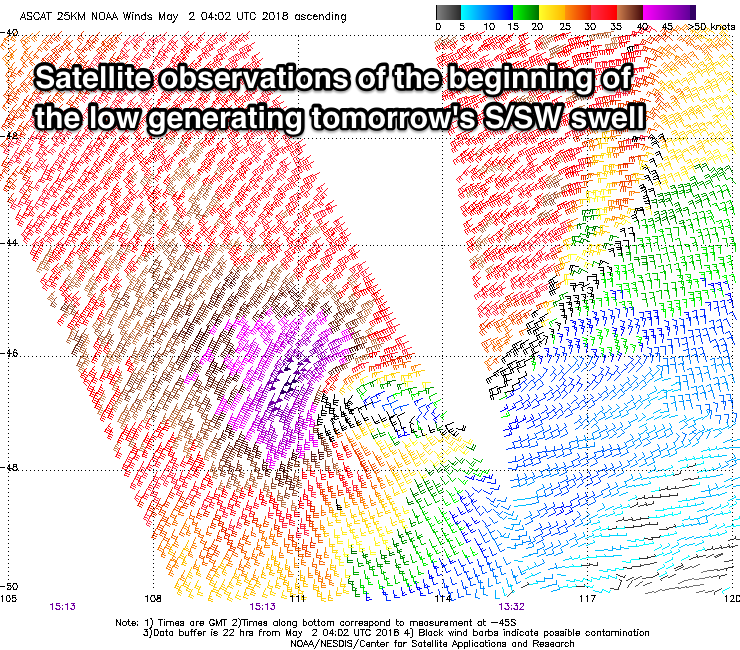 This is kicking up building levels of SW swell across all coasts today, but tomorrow morning we should see a large S/SW groundswell from the strongest part of the low.
Exposed reefs to the south swell should see easy 6-8ft sets early tomorrow morning, if not a little bigger, with a steady drop through the day, smaller into Friday and easing from 4-6ft (slowed by a reinforcing S/SW groundswell from the early stages of the polar front).
Mandurah should ease from 3ft, with 2-3ft waves in Perth. Winds will unfortunately remain onshore out of the S/SW tomorrow morning across the South West, swinging SW through the day, while Perth and Mandurah should offer windows of early S/SE-SE winds.
Friday will be cleaner across the South West with a dawn NE breeze (E/NE to the north) shifting light N/NW through the day but possibly tending variable. While not great this will provide a few options.
Small waves are due into Saturday and we're looking at E/NE-NE winds, favouring swell magnets across the South West.
Looking at Sunday and our new SW groundswell is still on track, with an initial relatively weak fetch of strong to near gale-force W/NW winds setting in motion an active sea state for a better fetch of gale to severe-gale W/SW winds to move over.
The fetch is a little more short-lived than forecast on Monday resulting in a slight downgrade in size, but we should still see Margs building to 6ft+ Sunday afternoon, with a secondary pulse Monday morning likely to come in more around 6ft to occasionally 8ft.
Mandurah should see 2-3ft sets later Sunday and Monday morning, 2ft in Perth.
The mid-latitude low that was forecast to drift in from the west and spoil our winds is still on track, with strengthening NW tending W/NW winds expected Sunday, swinging W/SW into the afternoon as the low pushes across us. This will add poor windswell into the mix that's likely to reach a stormy 3ft across Perth and Mandurah through the day.
Come Monday the low is expected to clear off quickly to the east, and light offshore E/SE-SE winds are more than likely with the secondary SW groundswell.
We're likely to see a third reinforcing SW swell for Tuesday and then new large long-period SW groundswell Thursday, but more on this in Friday's update.