Onshore winds for the most part with an oversized swell for the weekend

Western Australia Surf Forecast by Craig Brokensha (issued Wednesday 18h April)
Best Days: Perth and Mandurah tomorrow morning, Tuesday morning Margs, Wednesday onwards
Recap
Poor conditions yesterday and today with a touch more swell across Perth and Mandurah this morning, though below expectations. The buoys haven't really moved much through the day either, though only a weak mid-period swell was expected.
Today’s Forecaster Notes are brought to you by Rip Curl
This week and next week (Apr 19 - 27)
Today's new W/SW swell is showing a little better on the buoys this afternoon but in any case the easing trend tomorrow will be spoilt by lingering onshore SW winds across the South West, offshore to the north. We'll hopefully see clean easing sets from 1-2ft tomorrow in Mandurah and Perth, onshore everywhere Friday and small to tiny.
Looking at the weekend forecast and there's been no change to the oversized long-period and powerful W/SW groundswell due across the state, with the remnants of the storm currently weakening north of the Heard Island region.
The storm has done all of its work already and we'll see the long-period forerunners arriving later Friday afternoon, but with no size, ahead of the groundswell proper Saturday, peaking later in the day.
Margs should build to 10ft+ across exposed breaks with 3-4ft sets developing across Mandurah later in the day, and 3ft in Perth.
The swell should then ease from a slightly smaller size on Sunday but mid-latitude fronts pushing into us Saturday and more so Sunday will kick up some local W/SW windswell though below the size of the groundswell.
Margs should ease back from 8-10ft Sunday morning, with 3ft sets in Mandurah and Perth most of the day.
Conditions will be very poor all weekend with the mid-latitude fronts bringing strengthening N/NW winds Saturday and NW tending W/NW winds Sunday leaving no decent surfing options.
 Monday still looks onshore with an easing mix of windswell and groundswell, cleaner Tuesday but back to the small to moderate range.
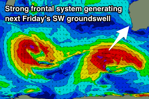
We should see some good new SW groundswell pulses developing mid-week across the state, with a larger pulse due Friday.
These swells will be produced by a series of strong polar fronts producing W/SW fetches through our south-western swell window on the weekend and early next week followed by a slightly stronger system mid-week.
The first swell for Wednesday should build to an easy 6ft if not more across the South West, 2-3ft in Mandurah and 2ft in Perth along with morning offshore winds, possibly holding into the afternoon as an inland surface trough deepens.
The secondary swell for Friday looks to be more in the 8ft range with favourable winds, but more on this Friday.