Good surf days Wednesday through Friday

Western Australia Surf Forecast by Craig Brokensha (issued Monday 11th September)
Best Days: Wednesday onwards in the South West, biggest around Perth and Mandurah Wednesday morning
Recap
Saturday saw nice clean waves but without any major size, coming in around 3ft across Margs while Perth and Mandurah saw a couple of nice sets. Sunday was average with deteriorating winds and less size, early, building into the afternoon.
Today a new SW groundswell is filling in across the state but conditions are average across all locations.
This week and weekend (Sep 11 - 17)
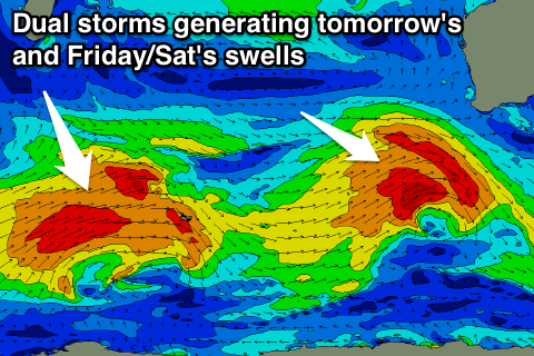
Today's new SW groundswell should peak this afternoon, only to be replaced by a larger swell tomorrow afternoon.
This swell is being generated by a vigorous mid-latitude front that's currently south-west of us. A great fetch of W/SW gales have been projected towards us, with a large SW groundswell due to fill in tomorrow, peaking overnight and easing Wednesday.
We can still expect Margs to reach 8-10ft into the afternoon with 3ft sets further north, easing back from 6-8ft+ and 2-3ft respectively Wednesday, further into Thursday.
 Winds are still looking average tomorrow with onshore and strong SW tending S/SW winds (W/SW early around Perth), but Wednesday is the day to surf with light offshore winds across all locations becoming variable into the afternoon (likely out of the Nth).
Thursday looks good as well with morning offshore winds and afternoon sea breezes.
Moving into the end of the week, our new SW groundswell for Friday is also still on track, with a strong polar low that's current west of Heard Island generating a broad fetch of W/SW gales due to continue moving east over the coming days.
This should produce a good SW groundswell that's due to build Friday and peak overnight before easing Saturday.
The swell looks to be smaller than tomorrow's with the South West due to reach 6-8ft by dark Friday, with 2ft+ sets to the north, easing from a slightly smaller size Saturday. Winds on Friday look good with E/NE tending light variable NE winds, while an onshore change is on the cards for Saturday and Sunday.
This change isn't linked to any major swell producer with some mid-latitude activity due to generate W/SW swells for later next week. More on this Wednesday.
Comments
Wednesday was smoking here up north heres one vid clip
Mad another of the early sesh but a new tripod arrived at 9:30 and we changed over tripods.
Some great waves in the mid-morning clip. Looks like your focus is a little off but. Do you have auto-focus options?
Yeah we were a bit dissapointed with the focus, also there was a hair inside the camera you can see on screen if you look closely. we cleaned it out.
We will be trying our best to fix the auto focus. i think it was focusing on the wave in front sometimes or therocks. Also the glare from the sun makes it hard to tell if its in focus.
Yeah, in some situations where there is water splashing up closer to the lens, manual focus is best to keep the camera from wigging out.
Ok ill try that next swell, or maybe even next crappy day to get used to it.