Large swell for the weekend but onshore

Western Australia Surf Forecast by Craig Brokensha (issued Wednesday 28th June)
Best Days: Perth Sunday morning, all regions Monday morning, Tuesday in the South West, Wednesday both regions
Recap
Average conditions across the South West yesterday morning, although cleaning up a little through the middle of the day.
Perth and Mandurah were clean but tiny.
This morning similar clean tiny waves were seen around Perth and Mandurah, while better offshore winds opened up some alright waves around Margs. A new S/SW groundswell is providing consistent 4-5ft waves across the reefs this afternoon with offshore E/NE winds (worth making the most of).
This week and weekend (June 29 – Jul 2)
Small surf will continue tomorrow across all locations and a fresh N/NE tending N/NW breeze will create terrible conditions at most spots. If you're desperate hit up protected swell magnets in the South West at dawn.
A very inconsistent new W/SW groundswell due into the afternoon and Friday morning will be spoilt by these winds, with onshore N/NW winds due to give into a SW change Friday.
This change will be linked to a vigorous polar frontal progression developing east of Heard Island this evening.
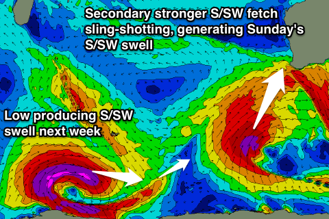 A good and slow moving fetch of gale to severe-gale SW winds will be projected towards us, with a slight sling-shot of near storm-force S/SW winds moving on top of the already active sea state.
This should generate a large long-period S/SW groundswell for the weekend, with an initial increase in size Saturday from the SW, followed by a reinforcing S/SW pulse Sunday.
Margs should build to a large 10-12ft by later Saturday afternoon/evening, with a slow easing trend from a similar size Sunday morning.
Perth should build to 3ft by the late afternoon with good easing 3ft sets Sunday morning.
Winds are still looking poor with a strong W/SW tending S/SW breeze across all coasts Saturday, lingering from the S/SW Sunday across the South West. Further north S/SE breezes should create cleaner conditions in protected spots.
Come Monday there isn't due to be much size left at all with fading 5-6ft sets across Margs and 2ft waves to the north with a light S/SE breeze in the South West, more offshore to the north.
Longer term a good long-period S/SW groundswell is due Tuesday/Wednesday from a strong polar low forming west of the Heard Island region Thursday.
We're probably looking at surf in the 6ft to occasionally 8ft range across the South West, smaller to the north with E/NE winds, but more on this Friday.
Comments
Best waves all week across Margs right now..