Poor weekend, not great until later next week

Victoria Forecast by Craig Brokensha (issued Friday 11th May)
Best Days: Monday morning, Thursday morning and Friday morning Surf Coast
Recap
Great reef waves most of yesterday across the Surf Coast with winds holding out of the W/NW as a good W/SW groundswell filled in, providing 3-4ft+ sets at magnets.
Today we've seen the deep powerful lows western flank slide in, bringing gale-force onshore winds and generating large victory at sea stormy conditions.
We'll see conditions remaining large, windy and stormy all day with only a handful of locations handling it.
Today’s Forecaster Notes are brought to you by Rip Curl
This week and weekend (May 12 – 18)
These notes will be brief as Ben is away on holidays.
The weekend isn't looking good at all with winds due to slowly ease, but persist from the south. Tomorrow the windswell will drop back along with fresh to strong S/SW tending S/SE winds, fresh from the S/SE Sunday.
Protected spots should still have a wave tomorrow, while the swell will be much weaker and smaller come Sunday.
 Some very inconsistent long-range W/SW groundswell is due to build through Sunday and then ease Monday, mixed in with a slightly better S/SW groundswell Monday.
The long-range swell was produced in our far swell window through the southern Indian Ocean and I can't see us seeing much size at all. The Surf Coast may see infrequent 2ft Sunday and Monday morning, mixed in with the windswell, and 3-4ft+ to the east.
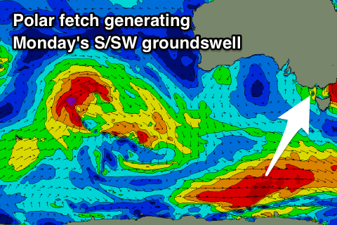
Monday's S/SW groundswell looks a bit better with a polar fetch of severe-gale W/SW winds forming late in our southern swell window this tomorrow.
The Surf Coast magnets should hopefully see 2ft to maybe 3ft sets Monday morning with 4ft+ sets to the east and winds will finally improve and tend variable. This may still be lingering onshore, so don't expect pumping surf, especially with the flukey swells.
Tuesday morning should see W/NW winds and clean conditions across the Surf Coast but only small to tiny and fading waves from 1-2ft.
An afternoon S/SW change should be seen as a surface trough and then high move in from the west, leaving lingering S/SW winds into Wednesday.
This will spoil a new mix of W/SW and SW groundswells, the least consistent and smallest being generated by a strong mid-latitude front that's currently projecting towards WA, while a more consistent SW swell is due from a polar fetch of storm-force W/NW winds well south of the country over the weekend.
Size wise we're looking at 3-4ft sets on the Surf Coast and 6ft+ waves to the east but with that onshore wind.
We're looking at better winds and good swells late week, but more on this Monday. Have a great weekend!
Comments
Craig, was the Tuesday arvo pulse on SC (discussed in Forecaster Notes 7 May) related to that system that went on to record the NZ 23.8m wave, southern hemi record. From your reply on that page, I think it was the same system.
What a beast. It felt strong while amongst it, and we were a long way away from it's core.
Yeah it was!! Nuts ay.
For sure & it had a habit of sets coming out of nowhere and dusting you, on top of its regular size.
You could do an article on this system, apparently groundswell for California off this one in a week, mad Tahiti and Cloudbreak probably before that. Would it light up the south shore of Oahu as well?