Weak swell energy Saturday, better from Sunday and into Monday

Victoria Forecast by Craig Brokensha (issued Friday 2nd May)
Best Days: Surf Coast Saturday, Sunday, Monday and selected locations to the east Monday morning, both coasts Wednesday morning
Recap
Fun 2-3ft waves across the Mornington Peninsula yesterday, remaining clean most of the day though windy into the afternoon. The Surf Coast was small to tiny and best on the exposed beaches.
This morning the swell was at a low point and with freshening NW winds that will swing more W through the day and strengthen. With this we're expected to see a late increase in size, but winds look to just only reach the gale-force range, hence no major size will be seen on the Surf Coast. Maybe 3ft sets at exposed breaks later but with average conditions.
Today’s Forecaster Notes are brought to you by Rip Curl
This weekend and next week (May 5 - 11)
Later today's building mid-period W/SW swell should be boosted slightly by a secondary front racing through our swell window and Bass Strait this evening, with a peak in size expected tomorrow morning.
Exposed breaks on the Surf Coast should ease from 3ft to possibly 4ft, smaller in more protected spots, with easing 6ft sets on the Mornington Peninsula. A W/NW wind will keep protected spots on the Surf Coast clean all day, but remember these spots will be smallish.
Our new W/SW and SW groundswells for Sunday/Monday are on track, with an initial fetch of pre-frontal W/NW gales moving in from the west today and tomorrow generating the initial W/SW swell Sunday morning.
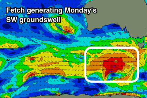 A broader and stronger post-frontal W/SW fetch will generate a better SW groundswell for very late in the day but more so Monday morning.
Size wise, Sunday morning's swell should come in at a good 3ft on the Surf Coast, with 5-6ft sets to the east. A bit more size may be seen later and a morning W/NW breeze will tend NW and then variable into the afternoon.
The SW groundswell should provide 4-5ft waves on the Surf Coast magnets Monday morning with 6-8ft sets to the east and winds will swing from a fresh N/NW'ly in the morning, more NW into the afternoon. Locations east of Melbourne may see N'ly wind at dawn.
Our onshore change for Tuesday now looks weaker, with a surface trough pushing through Monday evening due to leave light lingering SW winds that may even tend variable.
Some less consistent background SW groundswell energy from the earlier stages of the frontal progression linked to Sunday/Monday's swell will keep the Surf Coast around 3ft+ with 5-6ft sets to the east, smaller Wednesday as winds revert back to the N/NW.
A fun new W/SW swell is due to build Wednesday afternoon and peak Thursday, generated by a pre-frontal fetch swinging under the Bight Tuesday maintaining 3ft waves on the Surf Coast and 4-6ft sets on the Mornington Peninsula. We're likely to see a high pressure ridge move in though swinging early light winds around to the SE, but we'll confirm this Monday.
Longer term an inconsistent long-period W/SW groundswell is due Friday with plenty of swell into next weekend. Have a great weekend!
Comments
Craig,
Gary would like to know if Saturday's swell could transform itself from 'weak' to 'elite' with a few personal training sessions.
Gary will make himself available to don the mankini, mount the Bells headland, and crack raw eggs into the westerly wind if it would help.
Now that’s what I want to hear.