All blocked up

Victoria Forecast by Craig Brokensha (issued Monday 15th May)
Best Days: East of Melbourne Tuesday, Wednesday, Saturday and Sunday
Recap
Fun clean waves on the Surf Coast Saturday morning with 3ft of SW swell and offshore NW winds ahead of a shallow onshore change.
Sunday was average with bumpy small waves on the Surf Coast and peaky 3ft sets on the Mornington Peninsula for keen surfers.
Today the Surf Coast remained average with small bumpy waves, while a weaker E/SE breeze on the Mornington Peninsula provided OK waves across more protected locations.
This week and weekend (May 16 – 21)
As talked about last update, this coming period will be dominated by a broad mid-latitude low slowly moving in from the west, stalling while weakening over Southern Australia later in the week, only to be replaced by a secondary similar low later in the weekend.
These lows will firstly block our main swell windows, with us having to rely on frontal systems deflected around the boundary of this low, while also directing persistent winds from the north-east quadrant across the state.
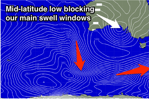 This will favour the Mornington Peninsula and Phillip Island beaches while the Surf Coast will be poor.
A new inconsistent S/SW groundswell is due to fill in tomorrow, providing fun waves across our exposed beaches into the afternoon. This swell has been generated by a fetch of pre-frontal W/NW gales along the polar shelf and we should see the Surf Coast building to an inconsistent 2ft to occasionally 3ft through the day with 3-5ft sets on the Mornington Peninsula (smaller early).
The swell is then expected to ease back from 2ft and 3-4ft respectively Wednesday morning, smaller Thursday.
Winds will improve through the morning tomorrow, swinging from E/NE to NE before going back to the E into the afternoon, while Wednesday should see N/NE winds, tending variable from the N'th into the afternoon. The Surf Coast will likely see light N/NW winds from mid-late morning.
Thursday is looking a little average with the smaller leftover swell and E'ly tending gusty E/SE breeze, kicking up an afternoon increase in windswell on the Surf Coast.
A low point in swell is due Friday morning, but a fleeting pulse of S/SW groundswell from a late forming polar front is due into the afternoon.
This swell isn't too significant with 2ft waves due on the Surf Coast and 3-4ft sets on the Mornington Peninsula mix in with some poor SE windswell. Winds will persist from the E/NE most of the day, fresh through the morning, favouring locations east of Melbourne again.
Through the weekend we should see winds take a more N'ly bias as the second mid-latitude low starts moving in from the west, but swell wise we won't see much at all.
The Surf Coast is expected to be small to tiny, while the Mornington Peninsula may see stray 2-3ft sets.
Longer term once the secondary mid-latitude low pushes east and across us, we'll hopefully see the westerly storm track firing up, but more on this Wednesday.
Comments
Geez, pretty average autumn so far IMO.. may normally pumps..