Broad mix of swells throughout the period; good weekend conditions

Sydney, Hunter and Illawarra Surf Forecast by Ben Matson (issued Wednesday 7th March)
Best Days: Most days will have plenty of waves, though Sydney thru' Hunter beaches will continue to be somewhat wind affected Thurs/Fri.
Recap: Onshore winds have spoilt a building S/SE tending SE thru' E/SE swell over the last few days with sets around the 3ft mark.
Today’s Forecaster Notes are brought to you by Rip Curl
This week and weekend (Mar 7-8)
Looks like a steady synoptic pattern will prevail for the rest of the week.
A large high pressure system over Tasmania extends a broad ridge through the Tasman Sea, driving strong SE winds into the Coral Sea. We’re seeing a spread of trade swell south into Southern NSW, but there are a few other embedded sources over the coming days that will contribute additional energy into the nearshore zone.
By and large, wave heights will continue to fluctuate in and around the 2-3ft mark at most open beaches both days. A small E’ly pulse is due on Friday from a minor E’ly fetch exiting western Cook Strait today, though wave heights probably won’t boost much about the existing trade swell.
There’s a more curious swell source on the cards, that was missed in Monday’s notes and is showing up in the model guidance for the end of the week. It's a small long period S’ly event that's due to arrive around lunchtime Thursday (South Coast) and late Thursday afternoon through Friday (everywhere else), originating from a poorly aligned but intense Southern Ocean low that displayed 50kt winds over the last few days, well SW of Tasmania.
Ordinarily, gale force westerly fetches from this quadrant of the Southern Ocean can be routinely ignored for Southern NSW’s surf potential, but there was enough W/SW alignment in the supporting fetch to give it some credibility. And with models estimating 0.8m @ 15 seconds S/SW (190 degrees) it certainly can’t be ignored. I’m going to hedge my bets with this one - as I’ve seen similar swells like this greatly overperform in the past - but I'll stick with inconsistent 2-3ft sets at south facing beaches (bigger in the Hunter).
If we see wave heights punch higher than this I won't be terribly surprised, however these kinds of acute, directional swells tend to only show properly at reliable south swell magnets.
Anyway, surface conditions look average with moderate, persistent SE winds across most regions for the next few days. They’ll be strongest north from Sydney through the Hunter, and should be generally light south from Sydney (where conditions should be OK), but they will certainly take the sheen off surface conditions.
This weekend (Mar 9-10)
The Tasman Sea ridge will remain strong into Saturday which means we’ll see a steady supply of trade swell spreading back into Southern NSW all weekend. Also in the water will be some leftover, easing S’ly groundswell, plus some mid-range E/SE energy from the fetch exiting western Cook Strait.
Wave heights should manage 2-3ft+ at most beaches both days, and conditions are looking pretty good in general with light offshore winds. Looks well worth the effort.
Next week (Mar 11 onwards)
We’ve got plenty of action in store for next week.
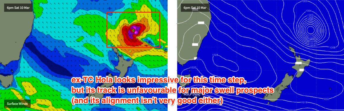
TC Hola is intensifying near Vanuatu at the moment, but will veer SE and track perpendicularly at speed through our swell window from New Caledonia to New Zealand over the weekend. This won’t be favourable for any major swell production - the best we can hope for is a small increase in E/NE swell through Monday (peaking Tues, easing Wed) with sets around 2-3ft. The synoptics look impressive in isolation (see below) but I just think it's moving too fast to allow enough time to develop any appreciable energy.
The start of the week will also see easing trade swell as the Tasman Sea ridge weakens, but there’ll be enough residual swell from other sources to keep the open beaches workable under a light variable flow.
A series of strong fronts will approach the southern Tasman Sea early next week, and generate a couple of mid-range south swells that’ll build through Tuesday afternoon and hold into Wednesday, probably reaching 3-4ft+ across south facing beaches.
Of even more interest is the potential Coral Sea cyclone mentioned in Monday’s notes. Model guidance is holding firm on this and it’s looking likely we’ll see this system track towards the SE Qld region mid-late next week (convenient timing with the Quik Pro in town too). Whether it pushes further south into our swell window remains to be seen - but it’s certainly a weather system to keep a close watch on.
See you Friday!