Easing swells this weekend, mid-next week looking good with an E'ly swell

Sydney, Hunter and Illawarra Surf Forecast by Ben Matson (issued Friday 16th June)
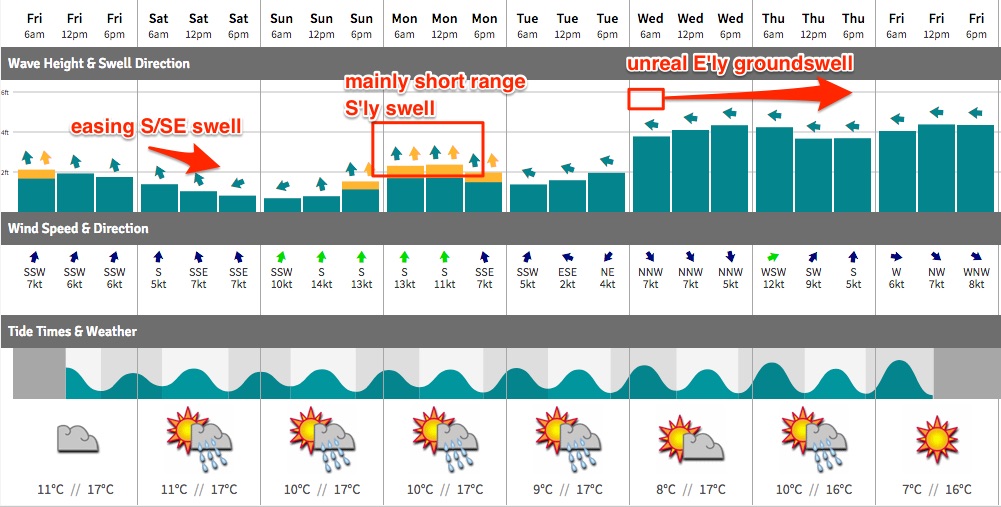
Best Days: Sat: early light winds and easing S/SE swell at exposed beaches. Wed onwards: good quality E'ly groundswell with light winds.
Recap: Nice waves for the last few days with a S’ly groundswell Thursday and a S/SE groundswell today both coming in around the 3ft mark, with bigger waves across the Hunter. Light winds have kept conditions clean.
This weekend (Jun 17 - 18)
The current S/SE groundswell will ease through the weekend, so you’ll have to be up early to make the most of the leftovers. We’ll probably be back to inconsistent 2ft+ sets at south facing beaches early Saturday (bigger in the Hunter) with a marginally smaller mix of this S/SE swell plus some residual E/NE swell, at remaining beaches. Expect the south swell to ease considerably throughout the day.
However, the E/NE swell should remain steady all weekend - though the models really don’t like it, and are showing hardly any surf over the coming days. This swell will be sourced from a moderate-strength (not so positive) but stationary (very positive) easterly fetch well off the Far Northern NSW coast, which should continue to supply us with some small workable waves both days. No great size is expected but occasional 2ft sets are likely at times, very inconsistent however.
The biggest threat this weekend is a freshening southerly breeze, as a broad coastal trough extends south from northern latitudes, eventually forming a closed low in the central Tasman Sea during Sunday.
Saturday looks like it’ll be spared of any great strength in our region (light SW in the morning, maybe moderate S’ly during the afternoon) but Sunday is shaping up to be quite wind affected with gusty S’ly breezes (outside chance for an early SW’er). These winds will whip up some local swell but it’ll be pretty ordinary.
So, make the most of Saturday morning before the S/SE swell eases and the southerly wind kicks in.
Next week (Jun 19 onwards)
Next week remains very tricky from a forecasting perspective.
The models have shifted around again on the precise details of the Tasman Low. Broadly speaking, the synoptics look much the same however the precise detail makes all of the difference in a surf forecast - in this case, the models now have the strongest winds around the low’s western flank (i.e. S’lies) instead of its southern flank (i.e. E’lies). The different in surf potential is significant for us.
Adding further complexity to the forecast is a series of deep, complex mid latitude lows traversing the waters south of Tasmania over the weekend. They're not very well aligned for our region but will nevertheless generate a sequence of small long period southerly swells that will glance the coast throughout the first half of the week.
I don’t think we’ll see much size from the south, perhaps stray 2-3ft sets at south swell magnets (bigger in the Hunter) but only at the upwards phase of each swell, and for limited durations - and very inconsistent between waves. I really think they’ll be fleeting events at best and shouldn’t really be considered as a serious swell source next week (though I will revise on Monday).
As such we’ll need to focus our attention towards the Tasman Low. It's initial stages will see a freshening E/NE feeder fetch over the weekend through the central Tasman, though no great size is expected in the surf department.
Whilst the low will become quite broad and strong through Monday, most of the fetch will be positioned at Sydney latitudes, aimed towards Queensland. So, we will see a smaller spread of E/SE swell fill in through Monday afternoon and Tuesday. Our model doesn’t like this scenario very much (suggesting 1-2ft surf Tues AM) but I think it could be worth occasional 3ft+ sets at open beaches. Let's take a closer look on Monday.
With the low remaining slow moving through the first half of the week, we’ll see a better fetch develop along its eastern flank and this is expected to generate a better E’ly groundswell that’s expected to fill in from Wednesday and probably hold into Friday. Being straight out of the east, it’ll favour most beaches more evenly and we could see 4-5ft sets at times.
Additionally, the low will have moved away from the mainland by this time so surface conditions should be clean with light winds.
Therefore, the pick of the forecast period is currently Wednesday thru’ Friday. But, I’ll update with revised information as it comes to hand.
Have a great weekend!
Comments
Yeah baby! that easterly fetch looks on the money for the lower M/N/C!
I was in the water as the swell started building early afternoon, rose from 1-1.5ft Manly to 2-3ft by 4pm.
we expecting that east swell to make an appearance this afternoon or moreso overnight and tomorrow?