Strong combo of swells ahead but difficult winds too

South-east Queensland and Northern NSW Surf Forecast by Ben Matson (issued Monday 9th April)
Best Days: Tues: early window of light winds in Far Northern NSW/SE Qld, with small easing E'ly swell. Wed: OK winds, and a mix of building SE swell (Northern NSW) and building E'ly swell (SE Qld). Thurs/Fri: strong SE swells (and some E'ly swell in the north) but local N'ly winds will spoil the party. Sat/Sun: rapidly improving conditions for the beachies with fun, easing surf.
Recap: It's been a good spell of E’ly swell, and though southern locations (i.e. south from Yamba) have enjoyed continuously favourable conditions, it’s taken more time for a major improvement to occur up north, thanks to its closer proximity to the trade belt. This has created an extended period of bumpy beachies but it all slowly improved over the weekend with very nice waves reported from most regions, just a few wobbles lingering on the Sunny Coast at times. Saturday managed 3-5ft sets in the north early (smaller to the south) and despite gradually easing through Sunday, even today was still a good 3ft at most open beaches.
Today’s Forecaster Notes are brought to you by Rip Curl
This week (Apr 10th - 13th)
Looks like a couple of problematic days of northerlies ahead, mainly for southern regions (take THAT Mid North Coast! That’ll learn ya for being so good for so long).
Prior to that, we have a southerly change advancing along the NSW coast right now, which reached Sydney this afternoon. Mode guidance suggests gusty winds (pre-dawn arrival Mid North Coast, late morning/lunchtime in the Far North, then extending across SE Qld early afternoon), but the reality is that it’ll be a thin strip of fresh southerlies and we won’t see an associated notable kick in local windswell in its immediate wake.
So, Tuesday will mainly see early light winds ahead of the change - albeit a brief window between Coffs and Byron (probably blown out across the Mid North Coast before sunrise) - plus slowly easing E’ly swell from today. Should be some fun beachies in the Far Northern NSW and SE Qld regions for a few hours before lunch.
Tuesday’s change will be attached to an evolving cut off low in the Southern Tasman Sea that is infinitely more complex (and thus, much more interesting). On paper, in single synoptic snapshots this low looks really good, developing storm force winds by Tuesday morning near New Zealand’s South Island, though aimed up into the northern Tasman Sea of which we’d see smaller side band energy across our coasts mid-week.
The low’s eastern track isn’t especially favourable for swell production either, as it’s moving perpendicular through the swell window, rather than working upon the sea state generated by early-stage fetches. This also reduces its surf potential.
But, by Tuesday morning it will encompass the entire eastern half of the Tasman Sea, and although not perfectly aligned within our swell window, will generate a strong S/SE tending SE groundswell that’ll provide some strong waves to exposed beaches south of the border.
Wednesday is when this new energy will start to kick in, via a couple of stages of stepladder S/SE tending SE swells. And with mainly light winds and afternoon sea breeze, Wednesday will see the best conditions of the working week, bar Tuesday morning in SE Qld.
Initially the morning should hold around 3ft+ across south facing beaches south of Byron, with smaller surf elsewhere, though a gradual increase is likely through the day.
The second, stronger SE swell is not expected to arrive until mid afternoon across the Mid North Coast, and late afternoon across the Far North Coast (probably not SE Qld until overnight) and this is expected to push 6ft+ at south facing beaches south of Byron in the few hours before dark. Afternoon sea breezes from the NE will probaly wreck conditions at the points though.
SE Qld will see much smaller surf from this source throughout Wednesday, building from 1-2ft in the morning to 2-3ft throughout the day at most outer points (bigger at exposed northern ends), but moderate onshore winds will cap the quality on the rising swell.
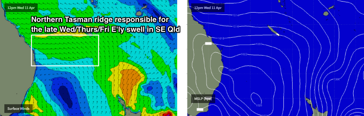
But, just to make things more complex, a brief but broad ridge building through the northern Tasman Sea from Tuesday through Wednesday will generate a mid-week pulse of E’ly swell for SE Qld and Far Northern NSW. This should supply 2-3ft sets across most coasts through Wednesday afternoon (smaller earlier), holding into Thursday before easing into Friday. The Sunshine Coast may see a few bigger waves form this source. But it’ll be smaller south from about Byron.
Thursday morning should see a peak from the aforementioned SE groundswell, with strong 6ft+ sets across south facing beaches south of Byron, though winds will already be around to the north by this time. Early N/NW winds are possible across some parts of the Northern NSW coast but it’ll remain more NE throughout SE Qld. Winds will straighten up from the north throughout the day though and could reach 25kts+ into the afternoon. The SE swell will be easing by this time, but it’s irrelevant with surface conditions expected to be a mess.
Across SE Qld, we won’t see as much size due the strong southerly component in the swell direction, and any strength from the northerly breeze will be quite detrimental to the points. In any case, we're looking at around 3ft of underlying trade swell plus an early peak in SE swell that could reach 3-5ft at exposed northern ends, though size will also ease here throughout the day. Thursday will however be all about the local winds.
And, that won’t be the end of the SE swell regime either.
A strong stationary polar low further SE from New Zealand today is meandering in a remote but relatively favourable swell window for our coast, and it’s expected to slingshot through the periphery of the window into Tuesday as it slams the southern tip of New Zealand's South Island. This will generate a smaller long period SE swell that’s due late Thursday across Southern NSW and should persist into Friday morning across Northern NSW. However it’s a much flukier swell source so I’m less confident that it’ll generate quality surf for our region (especially across SE Qld) and the persistent N’ly breeze won’t assist much either.
This swell should provide inconsistent sets around 3-4ft+ across south facing beaches (south of Byron) throughout Friday. Unfortunately, winds will remain out of the northern quadrant (possibly NW early) so you’ll have to find a sheltered northern corner. Expect smaller surf in SE Qld (again, with a healthy percentage of easing E'ly swell), with even fewer options thanks to a moderate northerly breeze.
Lastly, in and amongst this complex pattern we’ll also see a small E’ly swell through the back half of the week, generated by Tropical Cyclone Keni, which developed east of Vanuatu over the weekend. However, model guidance has sped up its E/SE track over the coming days and therefore it’s not viewed as a major swell source throughout the forecast period.
This weekend (Mar 14th - 15th)
Given the developing N’ly breeze throughout the second half of this week that'll probably ruin the vast majority of surf spots, we’re on track for a great weekend of waves thanks to an approaching frontal system.
This will freshen NW winds throughout Saturday - possibly gusty at times - ahead of a W/SW change on Sunday. Whatever surf makes landfall Friday will slowly ease in size so make the most of Saturday morning’s size - probably 3-4ft at south facing beaches south from Byron, 2-3ft at exposed northern ends of the Gold Coast. Smaller thereafter.
Next week (May 16th onwards)
Strong frontal passages usually mean strong, sustained south swell potential for our region, but the long term charts are a little mixed at this stage, possible stalling the Long Wave Trough node over Victoria, which would keep the storm track outside of our swell window for the first half of next week.
This suggests next week could be headed for a lengthy spell of much quieter surf, especially for SE Qld. Still, there’s a lot to happen between now and then.
Comments
A cool, offshore, Autumn day finally!
How fun was the early Sprout?
Offshore clean open beachies, fun banks
Not wrong Mata, clean little dredgers about.
If global warming means future weather becomes more extreme, longer and more intense Summers, and wilder winters, then Autumn could be a casualty?
D'Bah looking a treat, even with the S'ly now in.
