More punchy trade swell

South East Queensland and Northern New South Wales Forecast by Ben Matson (issued 6am Thursday 2nd April)
Best Days: Thurs/Fri: fun waves across semi-exposed points in SE Qld and Northern NSW. Sat: brief pulse of S'ly swell at selected south swell magnets in Northern NSW. Sun: good winds and an easing trade swell that should pulse in the afternoon (bigger on the Mid North Coast), and hold into Mon AM.
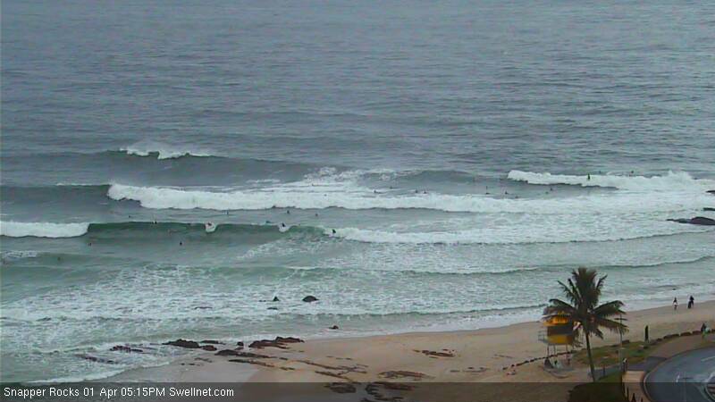
Recap: Small average surf on Tuesday but Wednesday saw building trade swell that easily reached 4ft across SE Qld into the afternoon. Conditions were generally quite average under a freshening E’ly airstream but it completely backed off and went offshore in some areas throughout the late afternoon (i.e. Coolangatta), allowing lumpy/glassy conditions to prevail for a few hours - see the surfcam grab below, from Snapper Rocks around 5:15pm Wednesday afternoon. These E’ly winds were lighter south of the border, and across the Mid North Coast it actually remained light and variable all day (albeit with smaller surf).
This week (Apr 2 - 3)
Some good news, actually - on Tuesday morning’s notes it was expected that the trades would weaken around Thursday, leading to a drop in size throughout Friday - but the latest guidance is holding the easing trend back a half day, which means we should see punchy E’ly swell through until Friday morning, ahead of a slow downwards trend throughout the afternoon.
Wave heights should fluctuate in and around close to what we saw Wednesday afternoon: somewhere near 3-4ft+ across the Gold Coast, a little bigger on the Sunshine Coast (4-5ft) but with smaller surf as we head south from Ballina - probably down to 2-3ft across the Lower Mid North Coast, with smaller surf again at south facing beaches.
Semi-exposed points should see a healthy percentage of this size range due to the easterly swell direction, but protected points are likely to be a couple of feet smaller.
And, no major change is expected in the local winds: for the rest of today, south of about Yamba we’re looking at light variable winds and sea breezes but north of here wind strength will continue to increase out of the east, with the strongest winds expected on the Sunshine Coast. Pockets of light variable winds are still likely at times across a few select areas (i.e. again, probably the southern Gold Coast) but in general it’s better to expect average conditions at times.
On Easter Friday, the weakening trades across our swell window will also occur across the coast, which is great news as it means a much improved overall outlook for SE Qld surf conditions under light variable tending onshore winds. With an early peak in size there should be some good waves across the region: don’t expect perfection but there should be some fun runners across the semi-exposed points.
Again, surf size will be smaller south of Ballina however the good news is that an advancing southerly change along the southern NSW coast has been delayed, and weakened in the latest model runs - it’s now unlikely to affect anywhere north of about Forster. So, winds should remain generally light and variable in most Northern NSW regions.
This weekend (Apr 4 - 5)
There’s been a few changes in the broad scale synoptic pattern for the long term. Most notably - the Tasman Low developing over the weekend now looks like it’ll be weaker, and short-lived - and will mainly supply swell to southern NSW.
However, an infeed of E/NE winds into the developing low will extend back to a stationary trade below south of Fiji, and this will continue to supply small easterly swell for the foreseeable future (this will maintain waves at all open beaches for at least the next week or so).
If anything, the Mid North Coast may pick up a brief shot of E or E/NE swell on Sunday from the developing low (say, 3-4ft, into the afternoon), but I doubt many locations north of about Coffs or Yamba will see an appreciable increase in size from this source (most coasts will probably see wave heights level out between 2ft and maybe 3ft).
As such, the overall weekend outlook is for slowly easing trade swells with mainly light winds - possibly some onshore tendencies in the southern regions on Saturday but likely to be light offshore throughout Sunday.
As mentioned on Tuesday, we’ll also have an acute south swell in the water on Saturday, generated by a brief cut-off low developing just east of Tasmania today - but I doubt it’ll provide waves to many beaches - just a handful of super reliable swell magnets in Northern NSW (maybe some 3-4ft sets). This swell will be all but gone by Sunday.
Next week (Apr 6 onwards)
Monday morning should see a continuation of the late pulse due on Sunday out of the east, but an easing trend will probably occur throughout the day. Light winds and sea breeze are once again expected, which should create great conditions for the morning surf.
So, even though the weekend’s developing Tasman Low now looks like it won’t be much of a swell producer for us, the good news is that in the wake of the departing low, the atmosphere near the coast is expected to remain quite unstable - and this is prime breeding territory for another low to develop.
And the models are indeed suggesting that we’ll see an upper trough trigger a low around Tuesday or Wednesday of next week, which suggests large surf possibilities for parts of the East Coast from Wednesday thru' Friday next week.
This will most likely favour the southern NSW coast, and to a lesser degree Northern NSW (and not SE Qld at all), but with the likely swell direction being out of the south and winds also out of the same quadrant, options will probably be limited to protected locations.
Otherwise, expect small trade swell to keep on keeping on for much of next week at the open beaches.
Comments
Now this is your classic piss wind gurgle swell Sheepdog.
Even with lighter or offshore winds around rain squalls it's still a mess.
still looks crowded
i bodysurfed it, got heaps of waves- not many quality ones. got a go pro now am trying to work it out, but surf not good enough to film. i will see if i can get u some vision of clean mid sized barrels if a i can
Yep... Sure is.... The bank looks pretty average, too.... Note the whitewater trail.... A sharp well defined bank would tidy it up a bit.... But still an average swell.... Mind you, that feb trade event didn't exactly go down in the history books for quality... or size... ;)
With respect to ben and craig, I will not supply the video link.... but if interested, FR, google "Video: Parko, Asher Pacey, Owen Wright & More Score Super Fun Snapper"
As one comment said.... "lame"......
PS- FR - I reckon you might get one of those "back of a low swells" come sunday/monday, which ben pointed to.... I cant remember which thread it was, but last year there was a similar swell..... Shifting ene 3 -4 foot swell.... I think we discussed the peculiarities of this type of swell.....
I've got my eye on that SD.
Hope alls well in the Apple Isle.
Yeah, ok, I suppose.... I could whinge but I won't.....
Found that thread.... Note rees0's photo at 7.12pm...
http://www.swellnet.com/reports/forecaster-notes/south-east-queensland-n...
Complicated few days but the overall picture looks fun. I got a couple thousand ks to do so will be dropping down some old beach tracks chasing some fun ones :)
It's Autumn April, yeah? :(
Tradeswell.... Followed by coastal trough/ecl.... Followed by probably more tradeswell.... Maybe one last bit of tropical activity post april 9th.....Nothing too out of the ordinary, don't you think, don?
I was talking about having to deal with relentless onshore winds at this time of year. We should be getting clean offshore pristine conditions each morning at this time of year.
Oh well... At least it's surfable... I'll see how you are early in august when your lips are cracked from the dry westerlies, staring out at the pacific lake for the 14th day in a row , mind surfing the 1/2 foot shorey ;)
That's exactly my point SD. Late Summer, and right through Autumn are the prime surfing time for SE Qld, particularly for our SC folk....and here we are, one month into Autumn, the start of April (only 4 mths until your dreaded August!!!) and we're having to deal with this relentless onshore shit!!!
Hmmm. April can have it's "tradewind moments".... Also have the odd cyclone too if you're lucky....... Can be a bit of a basket case/forest gump chocolate month...lol....... I think May has more chance of consistent sw to se'sters, with the high pressure belt moving further north....
Should be some ok waves in a few days, don.....
haha Don, you want more swell and better winds? Me too but happy to take what's coming. (:
And the northerly to make yet another return on sunday ffs.
It wasn't terrible yesterday. Interesting to feel the current taking you back out to sea for a change at snap. Kirra better later in the morning. Today was ok early, but cruddy by 10.
The bank is gone at snap, it has slid all the way down to kirra. Hasn't been that much sand down there in years.