Good fun Mid Wednesday, South Coast through the end of the week

South Australian Forecast (issued Monday 30th November)
Best Days: Mid Coast tomorrow afternoon, Wednesday and Thursday morning, South Coast Thursday, Friday, Saturday and Sunday mornings
Recap
Good waves Saturday morning with a light offshore wind and still solid but easing swell from Friday. The Middleton and Chiton stretches were best up until late morning when the sea breeze started to kick in. The Mid Coast was clean but tiny and around 1ft.
Sunday saw a period of variable winds early and smaller surf to 2-3ft across the Middleton stretch, with more size out at Waits and Parsons. Winds picked up from mid-late morning though, so the window of decent conditions was only small.
Today the surf was smaller but improving through the morning down South with a strengthening offshore NE tending NW breeze, but an onshore change is not far off across both coasts. (Change has just pushed through)
This week (Dec 1 - 4)
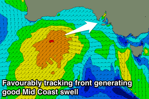
South Coast: A relatively weak but favourably tracking cold front pushing through the Bight will bring a building W/SW veering SW groundswell through tomorrow and Wednesday.
The onshore change that just hit will be related to the head of this front encroaching on us, but the front proper will push through tomorrow morning, bringing with it strong early W/NW tending SW winds.
 Protected locations will be worth a surf through the late-morning as the W/SW swell builds from a small 2ft at Middleton early to 3-4ft later in the day. The swell should then peak out of the SW Wednesday to 3-4ft+ at Middleton and 5-6ft at Waits and Parsons but with moderate S/SW onshore winds.
A slow drop in size is due through Thursday and Friday, softened by a reinforcing SW swell due Thursday afternoon from a weak trailing front being the man system.
Conditions are expected to gradually improve through Thursday morning as winds swing around to E/NE-NE before S/SE sea breezes kick in. Friday looks to be the pick of the week though with N/NE offshores and an easing swell from the 2-3ft range on the sets at Middleton and 4ft+ at Waits.
Mid Coast: The approaching front should kick up a late increase in W/SW windswell to 1ft or so this evening, with tomorrow morning due to also start tiny, but a strong afternoon increase in size to 2ft should be seen, peaking Wednesday morning to a good 2ft+.
Winds will be an issue tomorrow and onshore, but Wednesday is likely to see an early S/SE'ly creating good conditions before S/SW sea breezes kick in.
Thursday will also be clean with those E/NE winds, with a quickly fading swell from 1ft to maybe 2ft, but more so 1-1.5ft which will be ideal for beginners. Tiny 1ft leftovers are due Friday under those NE winds.
This weekend onwards (Dec 5 onwards)
South Coast: Early Saturday morning will start slow but clean with an offshore wind, and a new inconsistent SW groundswell is due to build through the day. This isn't a great swell with it starting to be generated in our far swell window in the Heard Island region today by a tight and intense low, which will weaken as it pushes further east.
An inconsistent 2-3ft wave should develop at Middleton into the afternoon with 4ft+ sets at Waits but as S/SE sea breezes kick in. The mid-late morning surf would be best.
The swell should ease through Sunday under hopefully a morning offshore wind, but we'll review this Wednesday.
Mid Coast: Saturday afternoon's kick in SW swell isn't expected to offer much size with tiny 1ft sets due, fading into Sunday.
Longer term a developing cut-off low in the Bight early next week may bring some new W/SW swell to the Mid through Tuesday/Wednesday next week, but this is a long way out.
Comments
Jeez, the Mid's looking super fun this morning. Brings back the memories!