Good potential from later this week onwards

Eastern Tasmania Surf Forecast by Craig Brokensha (issued Monday 28th May)
Best Days: Friday morning, the weekend onwards
Recap
Great waves again Saturday with the swell easing back to the 3-4ft range, though magnets should of still seen a few bigger ones, with Sunday dropping back further.
This morning there was hardly any swell left at all.
Today’s Forecaster Notes are brought to you by Rip Curl
This weekend and next week (May 26 – Jun 1)
Besides a tiny increase in N/NE windswell through tomorrow afternoon, fading Wednesday our next significant swell looks to arrive from the south through Thursday
A small low pushing up and past the south-east corner of the state during the day is expected to generate a fetch of strong to gale-force S/SW winds along the coast Thursday, kicking up a building S'ly windswell through the day, easing out of the S/SE Friday morning.
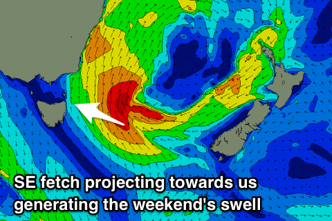 This low will be the catalyst for a stronger and broader Tasman Low forming east of us, with a good fetch of SE gales being projecting towards us through our eastern swell window on Friday.
We'll see a better aligned and stronger E/SE swell produced by this fetch, building through Saturday and then easing off slowly through Sunday, with a possible reinforcing east pulse on Monday.
Coming back to the sizes and Thursday looks to build to 4-5ft later in the day with strong S/SW winds, easing back from 3-4ft Friday morning with SW tending S'ly winds.
Saturday looks at this stage to kick to 4-5ft across open beaches with SW tending S/SE winds, slowly easing Sunday with a light morning W'ly. Monday's pulse will be with offshore winds as well, but we'll review this Wednesday.