Poor weekend of windswell, S'th groundswell pulse Monday morning

Eastern Tasmania Surf Forecast by Craig Brokensha (issued Friday 19th January)
Best Days: Monday morning south magnets
Recap
Great waves yesterday with a peak in E/SE groundswell from the strong Tasman Low to our east during the week, coming in at 3-5ft. This morning the swell was easing back from 2-3ft with offshore winds.
Today’s Forecaster Notes are brought to you by Rip Curl
This weekend and next week (Jan 20 - 26)
We'll continue to see the swell fade from the Tasman Low into the weekend, back from 1-2ft. An onshore change later today associated with a weak trough sliding in from the west will produce a very weak and small increase in SE windswell hardly reaching 1-2ft.
 Winds will be poor with this trough and onshore from the SE tending E/SE.
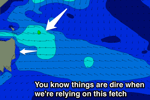
During Saturday we'll see a weak fetch of E/SE winds aimed towards us, keeping small weak 1-2ft sets max hitting the coast on Sunday with possible early variable winds, onshore through the day.
Into Monday the windswell will fade, but we're likely to see some small S'ly groundswell sets across south magnets.
A strong polar frontal progression is producing a fetch of W/SW gales and should just move into our swell window while weakening tomorrow.
A small S'ly groundswell is expected Monday morning to 2ft across south magnets with a morning W/NW breeze ahead of an afternoon S/SE change.
For the rest of the week there's nothing to major on the cards at all with a small weak NE windswell possible Tuesday, fading through the rest of the week. Some better activity may be seen from next weekend, but more on this Monday. Have a great weekend!