Trickier week of swell, with a return to action from the weekend

Victorian Surf Forecast by Craig Brokensha (issued Monday July 14th)
Best Days: This morning, tomorrow, Wednesday morning exposed beaches, Thursday morning for the keen, Friday, Saturday, Sunday, next week
Features of the Forecast (tl;dr)
- Easing SW energy into tomorrow with a reinforcing SW groundswell into the PM, smaller and fading Wed
- W/NW winds to the west tomorrow, variable to the east ahead of weak sea breezes
- Freshening local offshore winds Wed
- Inconsistent W/SW groundswell building Thu with fresh N/NW tending SW winds late AM
- Easing W/SW groundswell Fri with gusty NW tending W/NW and then W/SW winds into the PM
- Mod-large W/SW groundswell for Sat AM, easing with fresh W/NW-NW winds
- Smaller Sun with mod-fresh W/NW winds
- Mod to at times large W/SW groundswell for early/mid next week with NW winds
Recap
A fun pulse of mid-period swell for Saturday across the Surf Coast with clean conditions, bumpy to the east, with more energy seen into the afternoon but with an onshore change.
Yesterday’s strongest pulse of swell came in at 4-5ft on the Surf Coast and 6ft+ to the east with lumpy, bumpy conditions, best suited to those with lower expectations.
This morning is a bit smaller but cleaner and smoother across all locations, a bit too big to the east still and 3-4ft on the Surf Coast. The swell will continue to ease slowly as a trough brings moderate to possibly fresh S/SW winds mid-late afternoon.
This week and weekend (Jun 15 - 20)
We’ve got easing surf over the coming days following a peak in energy yesterday from the elongated, healthy polar frontal progression that fired up through last week.

One final pulse of reinforcing SW groundswell is due tomorrow afternoon, generated by a trailing front producing a pre-frontal fetch of NW gales aimed towards the polar shelf on the weekend.
This should maintain 2-3ft sets into the afternoon on the Surf Coast and 4-5ft waves to the east, similar in size through the morning. Winds are tricky and look to favour the Surf Coast and Phillip Island with W/NW winds to the west, which will be more variable across the Mornington Peninsula and likely light offshore further to the east.
Weak afternoon sea breezes shouldn’t do too much damage. Wednesday should be clean across both coasts but with easing size from tomorrow afternoon’s SW groundswell (2ft Surf Coast and 3-4ft to the east), and local offshore winds (N/NW Surf Coast, N/NE to the east) holding most of the day.
Looking at Thursday, and morning N/NW winds are due to shift SW later morning as a trough clips us and we’ll also see an inconsistent, long-range W/SW groundswell building through the day.
The source of this swell was a strong and persistent polar frontal progression that developed south of South Africa last week, pushing east along the polar shelf before weakening to the south-west of Western Australia today.
It’ll be inconsistent but we should see the Surf Coast building to an infrequent 3ft during the day with 4-5ft+ sets to the east, but with that change moving through.
The swell should ease from a similar size range on Friday morning as winds revert back to the NW, strengthening and tending W/NW ahead of an afternoon W/SW-SW change.
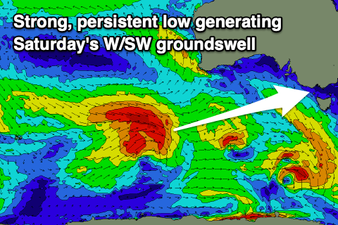
This will be associated with another frontal system moving through, though the earlier stages will generate a moderate to large sized pulse of W/SW groundswell. This will be thanks to a fetch of gale-force W/NW winds developing around a low just east of the Heard Island region today, projecting east while maintaining strength, only weakening south-west of us Thursday evening.

The swell should arrive overnight and peak Saturday morning with good 5-6ft sets on the Surf Coast magnets, 8ft to the east and with what looks to be favourable W/NW winds as another front approaches from the south-west.
We’re looking at another pulse of moderate to large sized W/SW groundswell from this secondary progression firing up between the Heard Island region and Western Australia later this week and weekend, arriving through the middle of next week along with favourable winds, but check back here on Wednesday for an update on this.
Comments
Just to that bit too big today, and consistent. Then when you get a couple of mins window for the in betweeners, it's like they couldn't break cause it was there too much water after the sets.
Does bigger period waves/sets bring in more water?
Great topic, worthy of a seperate forum thread.
I'm ready to read this
Actually it is most likely infragravity waves.
https://www.swellnet.com/news/swellnet-analysis/2022/04/13/infragravity-...
Good question / observation NB. I've noticed that on bigger days on the surf coast reefs.
Yep likely some IG influence, higher level in between sets, lower when they come through.
bloody hell , the Instagram influencers are everywhere ... ( he hehe)
Definitely felt like that was the case yesterday. Especially with that wavelength graph picture to help illustrate it.
Wasn’t overly big, just the consistency and quantity of waves in the sets where I was. Usually you wear a few and it’s fine but yesterday was easily noticeable.
Good to know.