Moderate pulses of westerly swell

Victoria Forecast by Craig Brokensha (issued Monday 8th August)
Best Days: East of Melbourne Tuesday, Surf Coast Wednesday afternoon through Friday, east of Melbourne Friday afternoon, Surf Coast Sunday
Recap
Tiny clean offerings on the Surf Coast over the weekend, better and fun to the east at swell magnets with inconsistent 3ft sets.
This morning the surf was smaller again, unsurfable on the 'Surf Coast' and small but clean on the Mornington Peninsula.
This week (Aug 9 - 12)
Another small and less consistent pulse of W/SW groundswell for tomorrow morning will keep the Mornington Peninsula from going flat, generated in our far swell window (south-east Indian Ocean).
Inconsistent 3ft sets are due on the Mornington Peninsula, while the Surf Coast will probably kick to 1-1.5ft. Fresh N'ly winds will keep exposed locations all day.
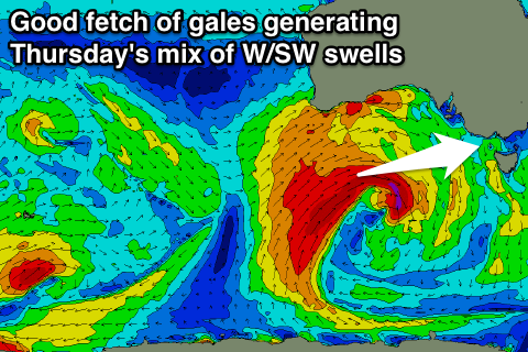 Now, we've got an upgrade in the tricky W'ly swells due from Wednesday, with a split mid-latitude low that's currently sitting south of WA expected to reconsolidate as it pushes slowly east over the coming days.
The small core-fetch of severe-gale to storm-force W/SW winds will expand slightly in scope through today, with a broader fetch of W/SW gales developing on the backside of the low, moving towards us tomorrow and Wednesday.
An initial pulse of long-period W/SW groundswell is due Wednesday afternoon, followed by a larger increase in mid-period W/SW swell Thursday.
The Surf Coast will start tiny Wednesday morning, but should build 3ft+ later in the day, with 5-6ft sets on the Mornington Peninsula.
Thursday's swell should come in at a better 3-4ft on the Surf Coast (with the odd bigger one possible as the stronger part of the swell fills in through the afternoon) and the Mornington Peninsula should offer 6ft+ sets (8ft sets likely into the afternoon).
Fresh NW-N/NW winds will favour the Surf Coast Wednesday, similar Thursday with a NW tending W'ly breeze.
Friday will then become cleaner to the east under N/NW tending N'ly winds along with easing levels of swell.
This weekend onwards (Aug 13 onwards)
A low point in surf is due Saturday morning with small 2ft waves on the Surf Coast and 4ft surf on the Mornington Peninsula but from mid-morning some new moderate sized W/SW groundswell is due to fill in.
This will be generated by a small but intense mid-latitude low developing in the south-east Indian Ocean, projecting a fetch of strong to gale-force W/SW winds directly towards and into us Saturday.
The low will actually race ahead of the swells its producing, resulting in an increase in mid-period short-range W/SW swell Saturday ahead of the groundswell Sunday.
The Surf Coast should build to 3ft but with W/SW winds, 5-6ft on the Mornington Peninsula, with the groundswell coming in around a similar size with better NW winds.
Small to moderate amounts of W/SW swell are due to continue into early next week from less than favourably aligned but good mid-latitude frontal activity under the country, more on this Wednesday.