Strong swells as far as the eye can see
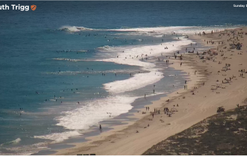
Very nice conditions are expected on all coasts this weekend with light variable winds and weak sea breezes both days.
A weakening trough of low pressure near New Caledonia is seeing easing E swells across the sub-tropics.
Friday looks solid as a range of mid period and longer period S swell trains generated by the proximate and deep fetches make landfall.
Today’s solid swell will hold through early Tuesday morning before easing during the day and continuing its downward trend into Wednesday.
The first cold front will then cross the region around 10pm Tuesday night (give or take) with a vigorous SW change.
The first front is due to push through mid afternoon on Tuesday, ahead of it we’ll see freshening NW winds...
Smaller surf than indicated on Fri due to the structure, strength and positioning of the Coral Sea low.
Stronger S swell on offer for Thurs as a trailing fetch slingshots into the Tasman on an already active sea state.
A strong winteresque frontal progression will deliver plenty of waves throughout the state this week.
We’ve got a dominant (1035hPa) high pressure cell sitting just north of the Victorian border, bringing settled conditions and light winds to Central/Southern NSW and strong but easing SE winds in the sub-tropics where a trough of low pressure in the Coral Sea is currently active but dissipating and moving East.