Strong south swells this week
Monday, 6 May 2024
Strong south swells this week
Monday, 6 May 2024
We've got upgraded south swells this week but with dicey winds.
We've got upgraded south swells this week but with dicey winds.
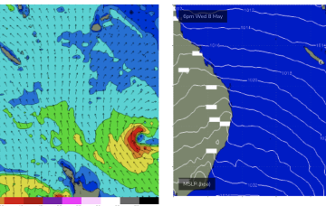
A new swell is due tomorrow with favourable morning winds, great as it eases on Wednesday.
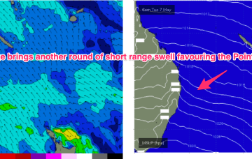
As the SE surge takes hold we’ll see a further increase in swell, possibly not until Wed now with fun surf extending right into the weekend.
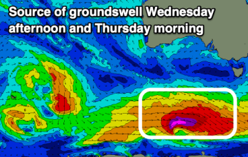
In fact, it becomes reinforced by a new high and this peanut high straddling Tasmania will set up a right of S’ly winds which will tend E’ly later in the week as high pressure moves to the E of the Island. Some polar low activity will supply some small S groundswell pulses this week.
The small westerly swell energy will fade, with inconsistent S/SW groundswell pulses for the South Coast.
In fact, it becomes reinforced by a new high and this peanut high straddling Tasmania will hold a firm ridge along most of the Eastern Seaboard with another working week of SE winds, gradually backing off into the weekend. A stalled trough looks to linger off the coast bringing plenty of unstable weather and possibly windows of lighter winds
The outlook remains favourable for the beaches with good pulses of S/SW groundswell.
In fact, it becomes reinforced by a new high and this peanut high straddling Tasmania will hold a firm ridge along most of the Eastern Seaboard with another working week of SE-E winds, gradually backing off into the weekend. A stalled trough looks to linger off the coast bringing plenty of unstable weather and possibly windows of lighter winds.
The high becomes even more slow moving as it approaches Tasmania so we’re looking at S-SE flow over the weekend. And with winds in the Coral Sea, plenty of E/SE swell.
Into next week and light winds Mon and Tues as high pressure approaches the state. Not much swell on tap.