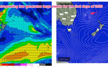
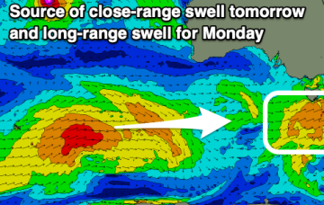
Fun swell tomorrow, then tricky thanks to local winds
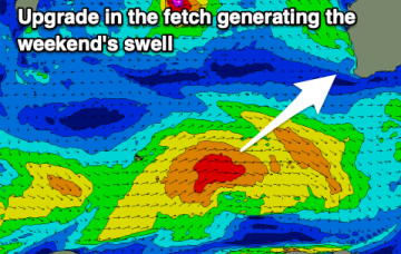
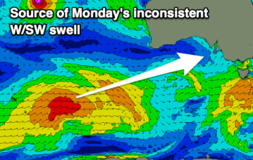
Generally small surf over the coming period with deteriorating and strengthening winds.
A dual-centred high straddles New Zealand with an elongated monsoonal low pressure trough located in the Coral Sea and extending into the near South Pacific. This is creating a long and broad E’ly fetch which is slowly extending southwards. As we near the end of the week, a more discrete surface low hives off the end of the monsoonal low pressure trough and retrogrades back into the Tasman Sea as it intensifies, generating large E’ly swells over the last days of 2022 and first days of 2023.
Easing surf with morning offshores tomorrow, deteriorating into Friday and then slowly improving on the weekend with plenty of size.
The coming period will favour the Mid Coast with a couple of windows for fun waves across the South Coast in between S/SE winds.
Smaller swells over the coming days but still a good size for the exposed beaches as winds improve Friday.
Today's swell will drop over the coming days and conditions will be best in the mornings ahead of a change Wednesday. Following this the outlook is slow.
We’re now on the cusp of a dynamic, tropical induced blocking pattern with low pressure hiving off an active monsoon trough in the Coral Sea and meandering in Coral Sea before drifting down into the Northern Tasman. The high pressure belt holds good support for this low pressure area with reinforcing cells stacking onto a slow moving system located at South Island latitudes. This will see an extended E’ly swell event, with days of pumping E/SE swell ahead.
The high pressure belt holds good support for this low pressure area with reinforcing cells stacking onto a slow moving system located at South Island latitudes. Eventually this large low pressure system drags a board fetch south enough to send useful E/NE swell to NE Tas.
We’re now on the cusp of a dynamic, tropical induced blocking pattern with low pressure hiving off an active monsoon trough in the Coral Sea and meandering in Coral Sea before drifting down into the Northern Tasman. The high pressure belt holds good support for this low pressure area with reinforcing cells stacking onto a slow moving system located at South Island latitudes. This will see an extended E’ly swell event, with days of pumping E swell ahead.
Fairly average conditions tomorrow, improving mid-week with a new swell and better winds.