Easing E/NE swell followed by weak NE windswell

Eastern Tasmania Forecast by Craig Brokensha (issued Wednesday 20th July)
Best Days: Thursday morning
Recap
A strong pulse of E/NE groundswell filled in yesterday with good 4-5ft sets across open beaches under morning offshores.
Today the swell was still strong in the morning with clean 3-5ft waves across open beaches, but a drop in size should have been seen this afternoon.
This week and weekend (Aug 21 - 24)
The deep low pressure system responsible for our current E/NE swell has broken down and pushed up the East Coast, cutting off the fetch of E'ly winds aimed within our swell window on the back of the low.
With this we'll see a steady drop in size, dropping from 2-3ft across open beaches and becoming small into the afternoon.
Conditions will be good through the morning with a light offshore but NE breezes will develop into the afternoon, so surf early for the biggest and best waves.
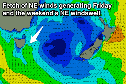 Friday should start off tiny but a surface trough moving in from the west squeezing with a strong high in the Tasman Sea will produce a fetch of strengthening NE winds in our swell window. A weak 1-2ft of NE windswell should be kicked up later in the day but with poor N/NE winds.
The fetch of NE winds are forecast to persist through Saturday and Sunday, keeping weak 2ft sets hitting north-east facing beaches but along with average N/NE winds.
Next week onwards (Aug 24 onwards)
The models diverge slightly on how next week will unfold but we may see a deepening surface trough off the East Coast dipping south and squeezing the northern flank of the strong high to our east. This could produce bigger levels of NE swell through the middle to end of next week across our coasts, but we'll review this again Friday.