Lots more surf ahead
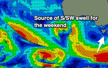
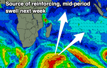
The high becomes even more slow moving as it approaches Tasmania so we’re looking at S-SE flow over the weekend. And with winds in the Coral Sea, plenty of E/SE swell.
Into next week and light winds Mon and Tues as high pressure approaches the state. Not much swell on tap.
Monster high pressure has barely budged since Wed, maintaining a S-SE flow right up the Eastern Seaboard, with a coastal trough ensuring plenty of unstable, rainy weather.
The coming days look fun and cleaner (besides Sunday).
Monster high pressure has barely budged since Wed, maintaining a S-SE flow right up the Eastern Seaboard, with a coastal trough ensuring plenty of unstable, rainy weather.
A large spike in new swell is due this afternoon, followed by large levels of W/SW groundswell on the weekend with more favourable winds.
Satellite observations confirm a great fetch aimed in the Mid's swell window.
The coming outlook is very out of season, with the exposed beaches fairing best.
Large swell for the weekend and early next week.
The coming days look sizey but with average winds, improving for the weekend.