Sydney, Hunter and Illawarra Surf Forecast (issued Monday 10th March)

And Tropical Cyclone Lusi has just been named in the Vanuatu region and is forecast track south-east while deepening over the coming days..

Please be right I need some waves I just broke my foamy so all I got is proper boards.
Fingers X
Ha ha evosurfer!

Latest model data has pushed the W'ly change forward a little, now suggesting we may see it push through on Sunday afternoon. It's also slightly sped up the southward track of TC Lusi but at this stage there's no need to alter size forecast estimates for Sun/Mon.
Sydney, Hunter and Illawarra Surf Forecast by Ben Matson (issued Monday 10th March)
Best Days: Thursday and early Friday: chance for light variable winds under a trough of low pressure, along with a slowly building trade swell. Saturday and Sunday: Building E/NE swell - large by late Sunday - but with difficult winds. Monday: pumping, easing E'ly swell with moderate offshore winds.
Recap: Small average waves over the weekend, as expected. No major change this morning either.
This week (Mar 11-14)
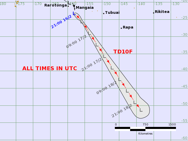
We've got one heck of a synoptic chart at the moment. Two Tropical Cyclones way up north (one in the Gulf of Carpentaria, the other in the Northern Coral Sea - both of which won't generate any swell for NSW or SE Qld), plus another Tropical Cyclone currently close to forming near Vanuatu. And, a broad, strong tradewind flow stretching from well east of the dateline through to the Qld coast.
Right now the tradewind swell is building across the SE Qld region (as per observations from the Quiksilver Pro, where wave heights slowly increased over the weekend), and the good news is that our most recent swell drought will be temporarily arrested by energy from this source over the coming days.
Initially, wave heights won't be very big but we will see a slow building trend all week. It seems our surf forecast model is under-calling this swell and I think by the end of the week (around Friday) we'll see peaky E/NE swell in the 3 to nearly 4ft range at exposed NE facing beaches, with much smaller surf at south facing beaches.
Prior to then, we'll see a slow increase from 1-2ft Tuesday and early Wednesday, building to 2-3ft from Wednesday afternoon into Thursday ahead of 3-4ft surf on Friday.
Local winds will be the main limiting factor this week. A strong, stationary high pressure system in the Tasman - also responsible for generating this trade swell in the first place - will direct moderate N/NE winds about the southern NSW coast. We are expecting a shallow southerly change to grace the South Coast during Wednesday afternoon but model guidance is now suggesting it may not quite reach the Sydney region (if it does, it'll be sometime Thursday morning, and it won't have much strength).
This change won't generate any swell however it should temporary halt the NE flow as a weak trough occupies the region, creating light variable winds (most likely Thursday). However NE winds are then expected to redevelop throughout Friday so we'll be back to the same pattern as earlier in the week.
So the take-home message for this week is: (1) biggest surf towards the end of the week, and (2) best conditions are possible Thursday under the influence of a local trough and the associated light winds, which may also persist into Friday morning. Outside of this expect variable conditions and a slowly building trade swell best suited to exposed NE facing beaches.
This weekend (Mar 15-16)
The biggest feature on the forecast charts is the developing cyclone near Vanuatu. And the good news is that there's been no major changes since Friday's notes.
We're looking at a rapidly intensifying system over the coming days that's expected to track southwards through the trade belt, with core E'ly wind speeds reaching up to 70-80kts (!). Although the supporting ridge, and the strength and location of the cyclone are very good for Australia's East Coast swell prospects, the only negative (re: surf potential) is the slightly-faster-than-optimal southward track. But it's still pretty good compared to recent cyclone track history.
Additionally, most model guidance has the cyclone undergoing extra-tropical transition during the latter half of this week and tracking to a position west of New Zealand - meaning we'll see only a moderate reduction in its swell generating capacity into the weekend (compared to a complete reduction, if the ex-TC tracked east of New Zealand, as is the more common route). So we should see several days of waves from this weather system.
So what can we expect surf wise? The peak of the swell is due Sunday however we'll see a strengthening of general trade swell on Saturday (that developed ahead of the cyclone). This should kick up most southern NSW coasts into the 3-5ft range throughout the day, but just keep in mind that there'll be a lag on the arrival of these swells in the south.
Sunday on the other hand is looking very strong as the groundswell starts to kick in. I've slightly upped size forecasts for late Sunday - when is when we'll see the bulk energy pass through - so look for 5-6ft surf through the morning to reach 6ft to maybe even 8ft at exposed spots throughout the day (again, smaller at south facing beaches due to the swell direction). However there will be long breaks between the bigger waves.
All of this is well and good, but we do have a rather large fly in the ointment for the weekend, by way of a ridge of high pressure in the Tasman Sea working with an approaching front west of the state to direct freshening northerly winds about the coast. In actual fact, Sunday could see 30kts or more as this (vigorous) change draws near the East Coast. If this happens we may have very limited options to pick and choose from. Let's reevaluate in Wednesday's update.
Next week (Mar 17 onwards)
Monday is the day! Sunday's large E/NE groundswell will have peaked and will be slowly easing (and probably more E'ly in direction by this time), but we're still on track for inconsistent 4-6ft waves in the early morning. More importantly, the westerly change expected on Sunday evening will have groomed the lines considerably so conditions should be first class. Expect a steady drop in size throughout the day but Monday is currently the highlight of the forecast period right across southern NSW.
Beyond Monday, we're looking at a smaller E/SE swell through Tuesday and maybe early Wednesday, originating from the remnants of the TC that generated the Sun/Mon swell. And, Sunday night's front looks like it'll generate a strong S'ly fetch in the southern Tasman Sea early in the week that should kick up a fresh southerly swell - potentially with some size, and duration - during the middle of next week (ie Tues thru' Thurs). I'll update these thoughts in more detail on Wednesday.