Northern NSW and South East Queensland Surf Forecast (Mon 2nd Nov)

Pretty major undercall Craig.
Yamba's come in at 6ft+.
Your Ballina reporter is smoking crack. It's easy 4-6ft here.

Yeah, pretty amazing at the size up there this morning, didn't expect 6ft.
BTW Ballina reporter has "solid 3 to 4ft waves now hitting the open beaches and even a few larger sets at swell magnets" So I'd take that as 3-5ft, close to your 4-6ft report.
Larger sets at swell magnets? Nup, it's 4-6ft at the Points. Look at the direction.
it's 6ft+ out the back of the bar and the Cape.
Point is, it's the first proper swell event here for months.
3-4ft is a beefy tradewind swell. This is orders of magnitude more solid than that. A proper swell.
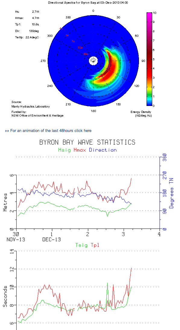
Thanks for the update Steve, jeez the Byron buoy readings are incredible, 3m of solid E/SE groundswell at 12 seconds!
Puzzling why the Wave Watch data is so far under at only 1.9m @ 9.3s this afternoon, musn't have resolved the system well at all.
http://new.mhl.nsw.gov.au/data/realtime/wave/Stn-byronbay
the ASCAT showed the retrograding of the fetch, thats always a sign that size will over achieve compared to models.
Solid six feet plus on the Point.

Aye FR what's happening on the voice today? I'm trying to get a mate pysched for a sickie tomorrow haha
Do it Mitch!
Haha Brissos are gonna be swarming the joint tomorrow. BTW, ACCESS had it retrograding ;-)
All models had it retro-grading Mitch, I personally didn't expect to see the size we're seeing. Alas it is pumping!

6ft sets north of Byron with a proper chunk to it. Definitely undercalled, but if you had a quick look at it you might have thought it was 3-4ft if you didn't see a set. Why was it undercalled? Lets pretend I'm not a meteorologist, why would a retrograding of the fetch result in over achieving swell?

Retrograding systems in the Tasman can sometimes result in a 'captured' fetch, which means the fetch is moving in the same direction and the same speed as the swell its generating. This amplifies wave heights and periods compared to what you'd expect from a stationary system.
M'kay thanks Ben for the education.
Ended up going nth, no secret spot but let's just say I went to the nether regions of he who sits on a throne, it was a consistent 3-4ft on tues arvo. Wed morn was 2-3ft and consistently setty, as opposed to sets + random peaks. Once the energy gets above 12secs, it really makes even a small &/or S swell pretty sick!
Northern NSW and South East Queensland Forecast by Craig Brokensha (issued Monday 2nd December)
Best Days: Tuesday when the swell kicks, Wednesday morning, Thursday morning, Saturday morning, Sunday morning
Recap
The weekend wasn't that special in terms of swell with small average waves Saturday and more size yesterday with cleaner conditions. This morning a fun pulse of S'ly swell is continuing across the North Coast, while the Goldy is also seeing some fun SE swell across open beaches.
This week (Dec 2 – Dec 6)
A fetch of strong to gale-force E'ly winds have been aimed towards us last night and early this morning (pictured right), with a weakening but persistent fetch of E/SE winds expected to remained aimed at us into tomorrow.
A medium sized E/SE swell will result that's expected to build strongly tomorrow afternoon to 3-4ft+ ahead of a peak overnight and drop Wednesday morning from 3-4ft on the North Coast. The Goldy will see a touch less size with sets to 3ft later tomorrow and early Wednesday with bigger 3-4ft waves at swell magnets. From here a slow and steady drop in size is expected into the end of the week.
Tomorrow morning should be clean with early SW winds, but Wednesday morning looks excellent with light W'ly winds ahead of fresh NE sea breezes.
The next considerable increase in swell is expected from the S'th on Friday as a strong cold-outbreak moves into the Tasman Sea. This will see an initial pulse of S'ly swell Friday replaced by a couple of secondary increases over the weekend.
This weekend (Dec 7 onwards)
As touched on above we should see a couple of medium sized S'ly swells over the weekend with favourable winds. We'll look at this again on Wednesday though.