Early Winter Outlook Southern NSW

And after a weekend where swell heights peaked well above expectations and winds remained extremely light for most of the day, even I'm getting excited about the low off the SE Qld/Nth NSW coastline early next week!!!

I'm surprised the BOM are calling 1.5m of E'ly swell in Sydney on Wednesday (where from?).
e wrote:Winds: Southerly about 30 knots. Seas: 3 metres increasing up to 4 metres during the morning. Swell: Easterly about 1.5 metres.
The models are starting to firm up this system as being similar to some of the ECLs we saw during that incredible six week patch in 2007. Time to dig up some archive charts for comparison methinks - I've got a feeling Wednesday's going to be very large.
Hmm, just dug up some archive charts and it's not the 2007 ECL sequence as I previously thought - must have been another event. In any case, it's the slight stalling of the low in its northward trajectory (early Wednesday, per GFS) that's of major interest at this point in time.
In any case, it's the slight stalling of the low in its northward trajectory (early Wednesday, per GFS) that's of major interest at this point in time.
By: "thermalben"
Are you talking about Wednesday next week (1 June) Ben? I'm not seeing any northward trajectory on the low.....looks to be tracking southwards based on the latest GFS long range charts I'm looking at??
This Wednesday Don.
This Wednesday Don.
By: "thermalben"
Sorry Ben....as Craig and I were talking about next week I assumed you were also.
Ah, I read the first part of Craig's post and chipped in before reading the rest!
Gee, someone please pinch me....it is winter next week right?? :)

Don, you do this every winter. E swells are not unusual for winter.
Tropical South Pacific lows, "weather bombs", hybrid lows, ECL's...they all occur from May-Aug.
The very finest E swells on record have occurred in Winter.
Not to mention offshore troughs etc etc .
Parkos foot gash swell last winter being Exhibit A.
Don, you do this every winter. E swells are not unusual for winter.
Tropical South Pacific lows, "weather bombs", hybrid lows, ECL's...they all occur from May-Aug.
The very finest E swells on record have occurred in Winter.
By: "freeride76"
Steve, just thought it was more typical for the lows in winter to track into the Tasman, giving us SE Qlders more S/SE'ly swells as opposed to E swells in SE Qld in winter. This latest set up tracks generally eastwards and parks near the north island of NZ with a high cradling it's southern flank. That looks more typical of a non-winter setup IMO, but I'm sure you'll be more than able to drag out some archive charts to prove me wrong.
Parkos foot gash swell last winter being Exhibit A.
By: "freeride76"
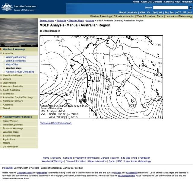
From what I recall, Parko did his foot in early July (around the 9th I believe). Just checked the archive charts from 1st July 2010 to 10 July 2010. Looks nothing like the setup progged for next week IMO.
Not that far away Don.
An exiting trough formed a low off the North Coast, which intensified as it tracked towards the North Island.
Not as strong as the system progged for next week but certainly of a similar ilk.
Not as strong as the system progged for next week but certainly of a similar ilk.
By: "freeride76"
More so that it didn't have the cradling high (as progged for next week) I believe.
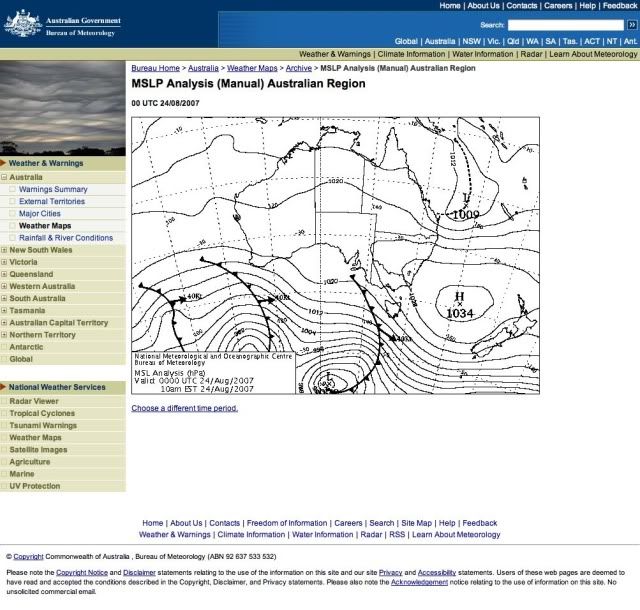
Here's another from end of August '07.
Tropical hybrid low/ECL that produced a solid week of 6ft+ E swell.
Parkos foot gash swell.
1033 Hpa high in the Tasman....trough of low pressure drifting towards the North Island.
June weather bomb.
6-8ft at Superbank.
10-12ft at Lennox next morning.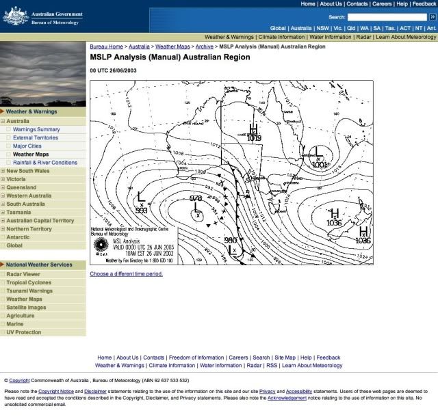
Deep trough linked to tropical moisture with embedded low pressure cells.
Unrideable 15ft+ surf.
Keep up the good work Steve ;)
Sorry Don, you got me started.
You know I always take this bait.
You know I always take this bait.
By: "freeride76"
LOL!!!

Good bait at that! I remember your report from that last 15ft+ swell. Huuuggeee!
Yeah it took a year for the near-shore bathymetry to correct after that event.
It actually permanently altered some surf breaks.
Yeah it took a year for the near-shore bathymetry to correct after that event.
By: "freeride76"
Feck I can only hope this up coming event does something for SE Qld's near shore situation as it's diabolical at the moment.
Really Don.....all I'm hearing is how epic the sand banks are at the moment. They sure look shallow.
Especially the Points and other selected spots.
Maybe your not looking at the right spots?
Really Don.....all I'm hearing is how epic the sand banks are at the moment. They sure look shallow.
Especially the Points and other selected spots.
Maybe your not looking at the right spots?
By: "freeride76"
Steve, you know I don't do points and generally only do beachies and I can tell you the beachies are fecked at the moment in SE Qld.
Certainly looking like a sustained period of good/fun swell on the cards....oh and did someone say damn fine looking winds!!! Now just have to find that top quality bank to match the top quality conditions coming up!!!
Hmmmmm, I'm liking the looks of the backside of the low/high combo!!!!
Yeah looks like the easterly swell will continue providing SE Qld and Northern NSW with small waves right through until at least Thursday next week.
I can't wait for this Friday/Saturday/Sunday/Monday around Sydney. Gonna be pumping!
Jeez I'm starting to feel all models have seriously under-cooked this swell after seeing the latest ASCAT and just getting out of the water as surf built into the solid 6ft range......lotta water moving.
Latest ASCAT looks INSANE.
Look forward to your in depth analysis of it in today's forecast Steve!! So ya reckon the weekend could be above expectations??
Well I think the peak of the swell was above expectations but not as much as I thought yesterday.
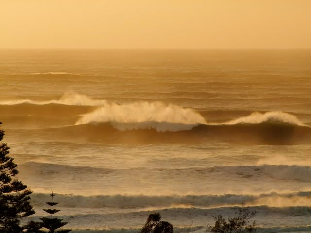
Solid 6-8ft here yesterday on dark and I just got smoked (leggie snapped, big swim in, board flogged on rocks) by a way bigger than 6ft bomb set.
Thats 2 bigger than 6ft E swells in a month.
Yeehaw.
2 snapped leggies and 2 beaten up boards.
how bad are the boards ? serious damage ???
Well after 3 or more weeks of consistent surf on the southern NSW coast, we're in a temporary lull of swell activity.
The swell will kick up again considerably from the south on Wednesday and hold into the weekend, but I'm more interested in next week's developments.
Besides a strong southerly groundswell for later Monday/Tuesday morning, we're likely to see a surface trough off the SE Qld, Northern NSW coast deepening and squeezing against a high pressure system to the south-east.
This trough could even form into a low pressure system, with plenty of E/NE swell filling into the middle of the week.
So it looks like we'll continue to see great surf into the start of winter!