The return of the sou'easter

Victorian Surf Forecast by Craig Brokensha (issued Monday 18th April)
Best Days: Wednesday for the keen on the Surf Coast, selected spots Thursday, Saturday morning for the keen on the beaches to the east, Sunday morning
Features of the Forecast (tl;dr)
- Moderate sized, inconsistent SW groundswell for this afternoon, easing tomorrow with moderate S/SE tending lighter S winds, fresh SW late
- Building mid-period W/SW swell Wed PM with fresh NW tending W/NW winds ahead of a late afternoon W/SW change
- Large SW groundswel for Thursday, possibly undersized early with gusty S/SW tending S winds while easing slowly
- Easing groundswell and mid-period swell Fri with moderate SE winds
- Easing mid-period S/SW swell Sat with light E/SE tending fresher S/SE winds
- Building inconsistent SW groundswell Sun with variable tending S winds
Recap
The weekend provided plenty of options for a quality waves with a temporary low point in swell Saturday morning ahead of our new, building SW swell. Conditions were a bit cleaner than expected on the Surf Coast and good 3ft+ sets, building to 4-5ft into the afternoon with weak sea breezes.
The beaches to the east were great in the morning, becoming too large into the afternoon.
The swell eased off quicker than expected into yesterday morning under a strengthening N'ly wind, shifting more N/NW into the afternoon on the Surf Coast. Easing 3ft surf was seen, 4-6ft to the east.
This morning we've got light winds ahead of a trough and S'ly change with smaller 2ft leftovers on the Surf Coast, 3-4ft to the east. A new, inconsistent SW groundswell is due to build through the day (better sets to 3ft now showing on the Surf Coast) but with deteriorating conditions due soon thanks to the freshening S'ly.

Calm before the change
This week and weekend (Apr 19 – 24)
After the recent week of good to great quality surf we've unfortunately got an average outlook this week owing mainly to the local winds, not due to lack of swell.
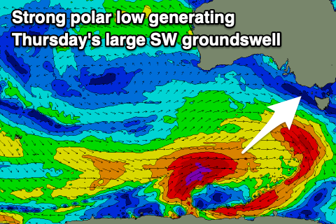
Looking at the current building SW groundswell, this was generated by a strong though distant and slightly fractured polar low at the end of last week and should see sets to 3-4ft holding on the Surf Coast, 5-6ft to the east.
A trough will bring a fresh S'ly change before lunch to make the most of the current conditions. Unfortunately lingering, moderate S/SE winds are due into tomorrow as the SW groundswell eases back from a similar 3-4ft on the Surf Coast and 5-6ft to the east.
Winds are due to ease a touch through the day, back to light into the afternoon before freshening later from the SW.
This freshening SW'ly will be linked to a cold front approaching from the south-west, attached to a vigorous polar frontal progression.
The front will approach closer on Wednesday, bringing fresh NW tending W/NW winds ahead of a late afternoon W/SW change as it pushes through.
 The surf will be smaller and back to 2-3ft on the Surf Coast, 4-5ft to the east though with some new, mid-period W/SW swell building later in the day.
Of greater importance is the large, SW groundswell due into Thursday across the state.
This swell will be generated by the polar frontal progression, with a fetch of pre-frontal, strong W/NW winds expected to be followed by a significant fetch of severe-gale to storm-force W/SW winds today and tomorrow.
The tail of the low will push up and into us Wednesday (bringing the late afternoon change) and this will also add some additional mid-period swell to the mix.
 Unfortunately a strong high will move in behind the front on Thursday, leaving fresh and gusty S/SW tending S winds, easing a touch through the day.
Size wise, the SW groundswell should peak around 5-6ft on the Surf Coast and 8ft to the east on the sets (possibly a touch undersized early), easing back from 4-5ft and 6ft to occasionally 8ft respectively Friday. Unfortunately a moderate SE'ly will persist Friday, lighter E/SE on Saturday as the swell eases further and becomes more accessible on the beaches.
From Sunday and more so into next week winds will slowly shift E/NE-NE as the high moves slowly east along with some moderate sized S/SW groundswell. We'll have a closer look at this on Wednesday though.
Comments
Wow, what a fun Easter on the SC :)
Really good few days there. Frothing.