Complex weekend, blowy start to next week, but not a lot of love in general
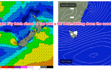
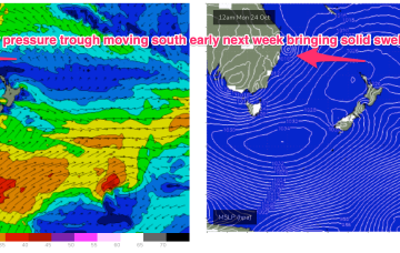
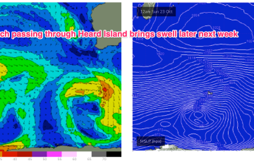
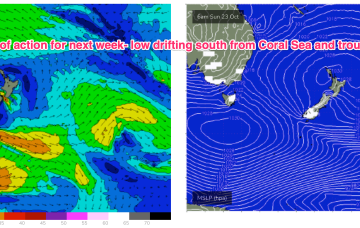
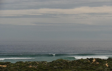
It's a tricky weekend of waves ahead. But there are items worth monitoring.
Dynamic weekend f/cast ahead as a strong NE fetch builds a chunky windswell and a trough then brings an extended period of elevated wave heights from the SE to E.
Very dynamic weekend forecast ahead as a low pressure trough forms off the CQ coast today and forms a small surface low which drifts south to hug the coast over the weekend, accelerating away to the south through early next week.
A trough of low pressure off the QLD Coast forms a small surface low over the weekend and this moves south Mon, interacting with a strong high moving south of Tasmania and another interior low forming in a trough line late in the weekend. This potent brew intensifies the NE-E/NE fetch forming in the Coral Sea and drags it south, where it more directly impacts temperate NSW.
We’ve got a couple of small swells inbound over the next few days, but Sunday has the most potential.
We’ve got a couple of small swells inbound over the next few days; a minor bump in size for Thursday and a slightly bigger pulse Friday.
A long, zonal fetch of gales reaches peak strength as it passes Heard Island Sun/Mon and this should generate a mid-sized, mid period SW swell building in Thurs into the 4-5ft range in the Margarets region, smaller 2-3ft in Mandurah, 2ft in Perth, and easing through Fri.
The onshore flow is enhanced into a deeper tradewind flow up in the Coral Sea, which gets a boost from a trough of low pressure expected to form off the Central QLD Coast this weekend before drifting south as a surface low, bringing sizey swell from the East and dynamic weather. The trough of low-pressure from inland Victoria is expected to drift SE of Tasmania over the weekend with plenty of swell expected.
The onshore flow is enhanced into a deeper tradewind flow up in the Coral Sea, which gets a boost from a trough of low pressure expected to form off the Central QLD Coast this weekend before drifting south as a surface low, bringing sizey swell from the East and dynamic weather.
We are in between patterns at present with a feeble trough delaying the start of the next pattern. That will see an approaching inland low and high pressure system generate increasing NE winds across most of the Eastern Seaboard. The onshore flow is enhanced into a deeper tradewind flow up in the Coral Sea, which gets a boost from a trough of low pressure expected to form off the Central QLD Coast this weekend. All of which is to say the dominant swell trains will be from the NE to E/NE through the short to medium term.