Average waves for the short term; long term resumes long period S'ly energy

Sydney, Hunter and Illawarra Surf Forecast by Ben Matson (issued Wednesday 9th September)
Best Days: Fri: improving conditions, nothing special though. Sun: small peaky waves with light winds. Late pulse of long period S'ly swell, holding Mon. Tues thru' Fri: strong, overlapping southerly swells.
Recap: Small surf and light winds padded out Tuesday, but we’ve seen freshening southerly winds today and building local southerly windswell, lacking in quality but pushing 2-3ft at south facing beaches. Certainly nothing terribly exciting.
This week (Sep 10 - 11)
Thursday looks pretty average. We’ll see two swells in the water - a mix of short range southerly swells trailing today’s change, plus an afternoon increase in distant E/NE swell from a small trough north of New Zealand a few days ago. South facing beaches should maintain 3ft+ surf, but it’ll be smaller elsewhere, especially the morning before the new E/NE energy kicks in. Late afternoon should see inconsistent 3ft sets at most open beaches.
The main issue on Thursday will be persistent SE winds thanks to a ridge of high pressure pushing in behind today’s change. We’ll see lighter strengths south from the Illawarra, but it looks like the strength of the synoptic flow may override some of the local topographical influences we often see across the Sydney and Hunter region. So, isolated pockets of early SW winds will be rare at best, if they appear at all. Keep your expectations low.
The models have moved things around for Friday, and are now pushing the trough into the lower Coral Sea (rather than stalling across the western Tasman Sea) which means a persistent mix of SE and E/NE swells across open beaches, with peaky, disjointed sets around the 3ft mark.
Fortunately, conditions will clean up slowly thanks to an easing of the pressure gradient, resulting in lighter onshore winds - though still holding out of the eastern quadrant. However, Friday morning has a much better chance of seeing light/variable conditions and therefore lumpy but somewhat smooth wave faces.
Again, it won’t be great but there’ll be some options opening up on Friday for keen surfers.
This weekend (Sep 12 - 13)
The shifting models guidance over the last few days has resulted in a downgrade for Saturday’s surf, even though confidence (in Monday’s notes) was only low anyway.
An approaching trough will freshen northerly winds about most coasts on Saturday, before easing and swinging light NW on Sunday. So, the second half of the weekend will by far have the best conditions.
As for surf, Saturday’s freshening N’ly wind will generate a small building local windswell through Saturday (easing quickly Sunday) but the primary sources of swell will be peripheral SE swell from (poorly aligned) trailing frontal activity in the south-eastern Tasman Sea on Wednesday and Thursday, and a spread of E/NE swell from a ridge in the northern Tasman Sea from Friday onwards.
The first two swell sources won’t allow for much more than 1-2ft sets, but the E/NE energy should keep most open beaches somewhere between 2ft and 3ft. So, it’ll be more than enough to offer fun waves at most coasts.
Also on the cards is a small long period south swell on Sunday afternoon, generated by the first in a series of interesting swell events from the Southern Ocean, sourced from an intense, bombing low south of Tasmania around Friday (see below). It’s still very early days but south facing beaches could be looking at late, inconsistent 3-4ft sets from this pulse. More in Friday’s notes.

Next week (Sep 14 onwards)
Long term model guidance has eased back the prospects of lingering instability through the lower Coral Sea and western Tasman Sea.
Nevertheless, a steady ridge through the northern Tasman Sea should maintain small, intermittent E/NE swells for the first half of next week, but of much more interest are a series of significant Southern Ocean lows passing below the continent from Thursday/Friday onwards.
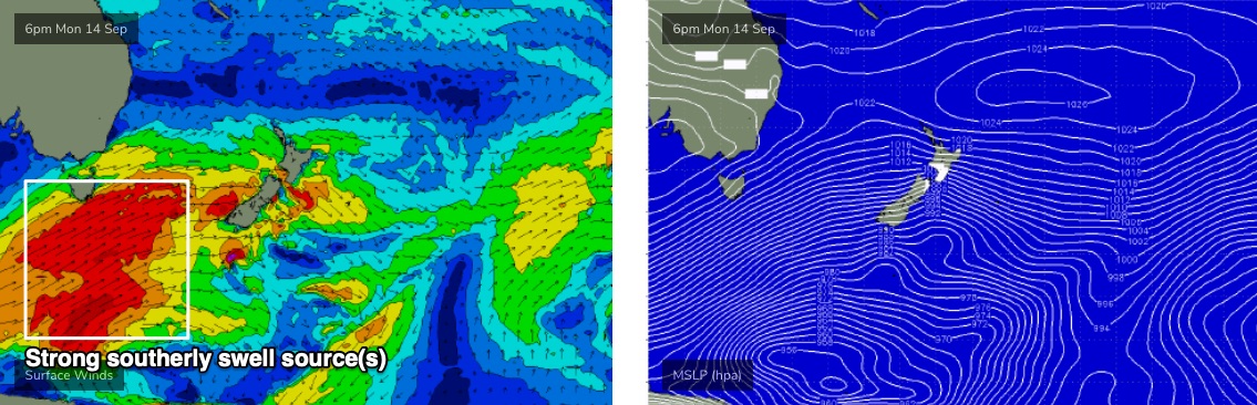
The first low looks to be enormous (see above), with very strong core winds south of Tasmania on Friday (60-70kts) but it won’t be well aligned through our swell window. The leading edge is expected into Southern NSW on Sunday afternoon (mentioned above) and we’ll then see the swell energy plateau into Monday. The acute direction and very large periods will cause a wide range in size from location to location, but very inconsistent 3-4ft sets at south facing beaches is a useful ballpark for now.
Further fronts are then expected to push through the lower Tasman Sea later Monday through Tuesday and Wednesday (see below), better aligned though still very SW in orientation. However the latest model guidance suggests a very broad, sustained fetch which should in multiple, strong overlapping southerly swells through the rest of the week. Early indications are that the peak of this event (probably around Wednesday) could reach somewhere in the 4-6ft+ range at reliable south swell magnets, but I’ll have more on that in Friday’s update.
See you then!
Comments
Ben does the size estimates in this forecast hold for the south coast near Moruya, Fri through Sunday? Looking at seabreeze, looks like the local windsell on Sat will be stronger but hard to say about the other swell sources on Fri & Sat.
It hasnt shown much size these last 2 days around here. I wouldnt hold my breath.
FriYaah notes?