
Solid south of the border as low forms in Tasman Sunday

Southeast Queensland / Northern New South Forecast by Steve Shearer (issued Wed 4th Nov)
Features of the Forecast (tl;dr)
- Building S'ly swell for Northern NSW on Fri, with early offshore winds (tiny in SE Qld)
- Tiny weekend persisting in SE Qld, maybe some stray small waves at S-swell magnets early Sat
- Easing S'ly swell Sat in Northern NSW, then a chance for a increase in solid S swell late Sun was low forms in Tasman
- Solid S'ly swell likely early next week (mainly Northern NSW)
- Potential for another S swell end of next week if low forms in Tasman
Recap
Small and weak E swells yesterday offered a 2ft wave at best with clean to clean-ish conditions for the early before NE winds kicked up. Early offshore winds brushed clean mostly weak E’ly swells to 1-1.5ft with S-SE winds now pushing up through NENSW, reaching the border through the a’noon.

Tiny but nice with the bluewater
This week (Nov 4 - 6)
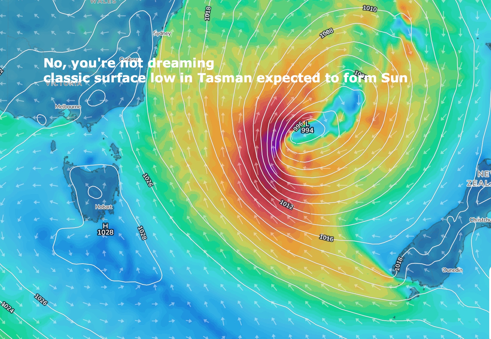
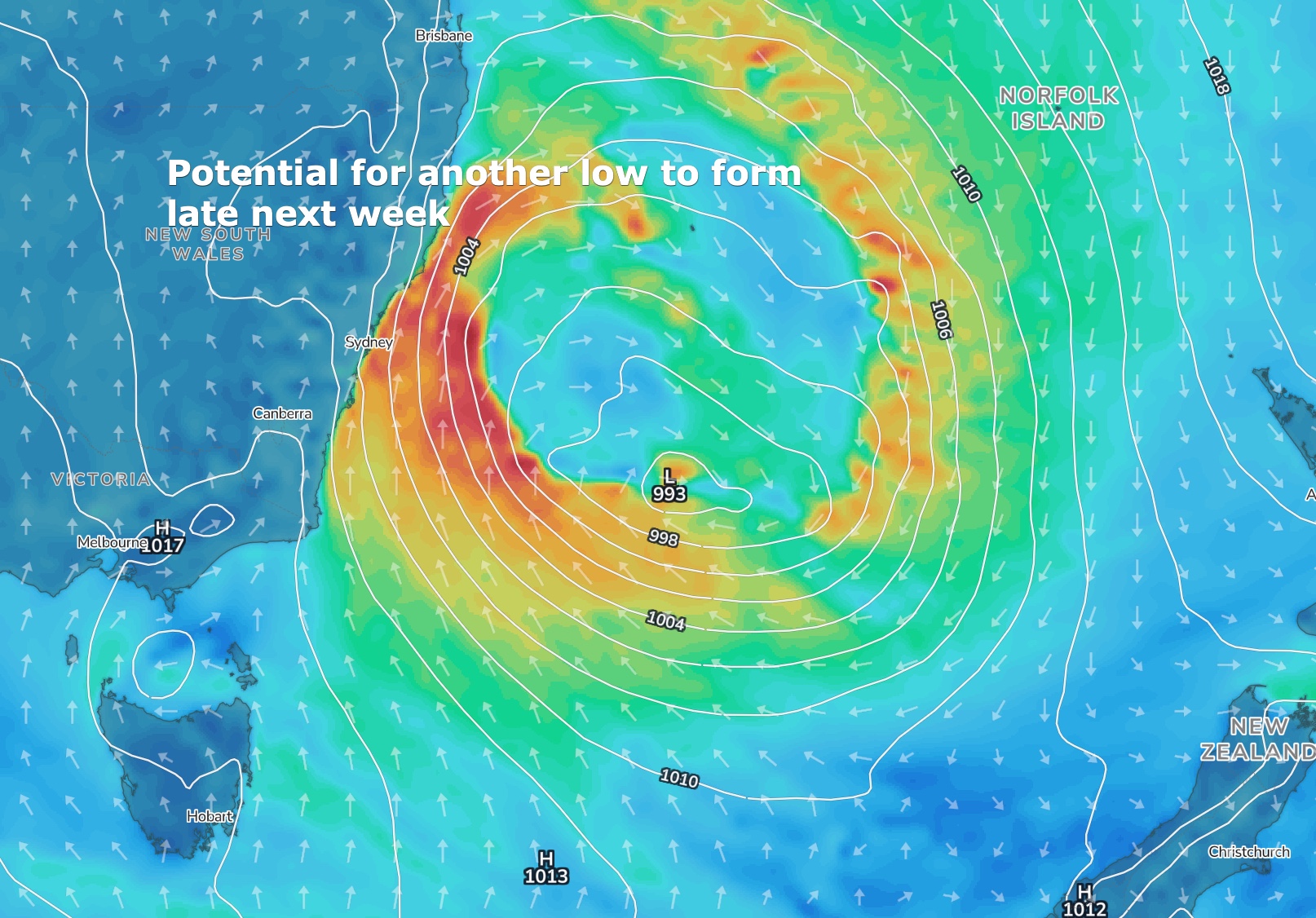
We’ve got a weak, but very unstable pattern unfolding as a low pressure trough linger off the NSW coast, linked to a pre-monsoonal trough snaking across Northern Australia and then extending southwards to an approaching trough and cold front. The passage of the Southern trough in the short term brings a small S swell event but over the weekend we’ll see a much more robust front and surface trough develop, backed by a strong high moving below the Bight towards Tasmania. Once that kicks off we should see a surface low develop in the Tasman with days of potentially very sizey good to great surf into next week. Models then suggest another back-up low forming later next week with more sizey S-SE swell potentially on offer.
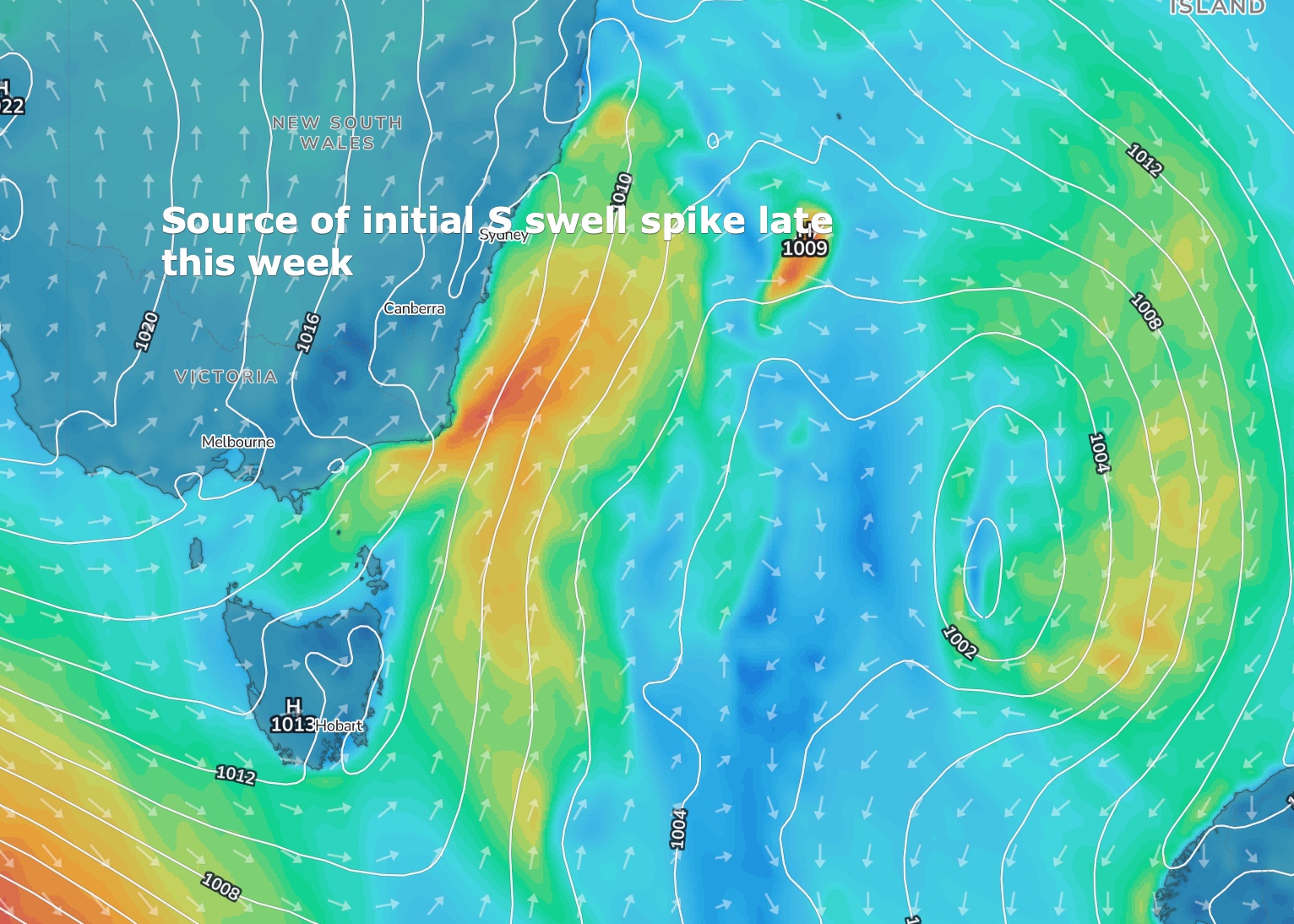
In the short run expect a period of offshore W or even W/NW winds early before the trough pushes through, bringing SW-S winds initially to the MNC then S-SE winds to the North Coast through the a’noon, with N’ly winds in SEQLD likely until dark. Another day of small surf with background E’ly swells hovering in the 1-1.5ft range and an occ. 2ft set.
The proximate fetch quickly moves away into Fri morning with a lingering SW-S flow early, tending S-SE before ending up as a light/mod E/NE seabreeze. Fri looks fun south of the border with S swell to 3-4ft at S facing beaches, with background E’ly swells holding a 1-2ft wave in SEQLD.
This weekend (Nov 7 - 8)
No great change to the Saturday outlook. Not much on offer in SEQLD with small E to NE windswells to 1ft and NW tending N-N/NE winds as the trough system approaches. South of the border should see some fun S swell to 2-3ft early, easing through the day. Sun will be a different story.
By Sun AM the trough will be elongating through the Tasman, backed by a strong high approaching Tasmania. Strong S’lies look to reach the border by first light or just after and extend through SEQLF into the morning. The trough deepens through the day to a broad surface low with severe gales to potential low end storm force winds developing in the Central Tasman. Not much surf expected SEQLD Sun but south of the border we should see a spike in new S swell establish through the lunch/early a’noon on the MNC-Coffs, pushing into the rest of the northern rivers over the course of the a’noon into the evening, with surf building to 3-4ft, reaching 4-6ft on the MNC by close of play. A further aggressive building trend is mostly lost to nighttime hours.
Next week (Nov 9 onwards)
Expect some revisions Fri as we get a more detailed resolution on next weeks Tasman low. At this stage, it’s looking solid but not too sizey for NENSW with winds better aimed at southern/central NSW and without too much swell getting into SEQLD. Still solid Mon for November but potentially down a bit from Sun night as the initial swell spike winds back a bit - unlikely to drop below 4-5ft in NENSW- with continuing SW-S winds. SEQLD is likely to be in the 2 occ. 3ft range Mon at S facing beaches and northern corners.
A secondary pulse of S-S/SE swell is likely into Tues, pushing surf back up into the 4-6ft range in NENSW, smaller 3 occ. 4ft in SEQLD at S facing spots.
Offshore winds are likely Tuesday morning as the low moves away and weakens, offering potential for sizey, clean surf.
An easing trend through Wed and Thurs is likely to be fairly pronounced with user friendly surf returning through this period and winds shifting N’ly.
More, highly unstable atmospherics then suggest another surface low forming later next week off the Central NSW coast. Way too far off to have any confidence in specifics but with both major models in agreeance on the broad scale pattern confidence is moderate and building we’ll see another spike in S swell late next week with Fri looking the most likely day and wave heights provisionally north of 6ft.
Let’s see how this all looks on Fri before we pull the step-ups out of the rafters.
Seeya then.
Latest news
Surfing On The Olympic Chopping Block
Laurie Towner's Balancing Act

Two Surf Spots, Both For Sale
Snapper Night Surfing Gets The Nod
Watch: Laurie Towner // Equilibrium
Pipe Masters 2026: What Everyone Needs
Watch: Kipp Caddy // Slab Sessions Ep.2
Watch: Every Excellent Wave // The Philippines Pro
Comments
Got a bit excited when model runs yesterday showed the low positioning further E in the forecasts. Back to tighter to the coast and mostly blocked by the hunter curve. Will be basically flat in my neck of the woods, the torture continues.
Still some model variation on the positioning Tiges- see what happens.
Yeah looks like it's just sitting a touch too far west.. carn!
Can only hope. Golden rule around here... Never, ever get excited about a southerly swell.
Seems you moved to the Sunny Coast Tiges ;)
Lovely day up here, for a swim!
35.8 degrees in Cooly this afternoon. Hottest it's been in ages!
Byron dropped ten degrees in an hour with the southerly change. Hasn't reached the border yet though.
change hit earlier than anticipated???