A couple of swells though winds will create issues

South Australian Forecast by Craig Brokensha (issued Wednesday 11th November)
Best Days: Keen surfers protected spots down South tomorrow from mid-late morning and Friday morning, Mid Coast Thursday/Friday for the desperate, beginners on the Mid Saturday, South Coast Saturday morning, Sunday morning South Coast
Recap
Clean but tiny surf down South ahead of stormy weather later in the day, tiny to flat on the Mid Coast.
This morning there was still a bit of stormy weather moving through, emanating from a strong mid-latitude low in the Bight.
A tiny windswell was kicked up for the Mid Coast to 1ft with early light winds but these are already starting to strengthen, with 1-2ft waves down South earlym under a light W'ly breeze. Winds have since swung more offshore but the swell has dropped.
This week and weekend (Nov 12 - 15)
The mid-latitude low that's currently moving in from the west is weakening while moving more into the Mid Coast's swell window (sitting just north of it before), with a great fetch of strong to near gale-force W/SW winds due to be projected east.
 This should produce a good mid-period W/SW swell, mixed in with some smaller W groundswell and localised windswell, all culminating in 3ft surf across the Mid Coast tomorrow but with strong W/NW tending W/SW winds. This will create choppy, poor conditions.
The South Coast will be cleaner in protected spots through the morning but the swell will be small and building to only 2ft+ or so off the Point with 3ft sets at Goolwa into the afternoon. This will be as winds swing onshore so all in all it's not looking great.
Friday looks to persist around 2-3ft across Middleton as the swell direction swings more SW but remains low in period, with the Mid Coast easing from the 2ft range. Winds will be similar to Thursday but with less strength and fresh W/NW tending W/SW down South, and fresh W/SW most of the day on the Mid.
We'll finally see more variable and local offshore winds kick in Saturday but the swell looks tiny and to 1-1.5ft on the Mid Coast, easing from 2ft+ down South.
Our new, inconsistent W/SW groundswell for Sunday/Monday is on track, with a strong mid-latitude low forming last night, north-east of the Heard Island region.
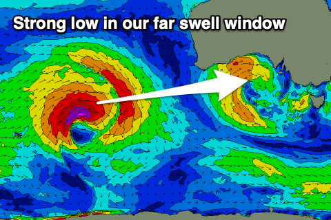 A fetch of severe-gale W/SW winds are being generated through our far swell window, with the low and fetch due to weaken slowly into this evening and tomorrow morning while pushing slightly east.
An inconsistent, long-period W/SW groundswell is due from this source, arriving overnight Saturday and building Sunday through a peak into the afternoon.
While inconsistent, the swell should provide good 2ft sets across the Mid Coast swell magnets on the favourable parts of the tide, while the South Coast should build to 2-3ft across Middleton through the day.
Unfortunately a trough will bring a change through Sunday with early fresh N/NE winds due to swing W/SW around midday, but we'll review this Friday.
It looks like onshore winds will persist into early next week, while some new W/SW swell energy is on the cards for mid-late next week from frontal activity south-west of WA. More on this Friday.