Waves all week, large, stormy weekend

South Australian Forecast by Craig Brokensha (issued Monday 30th March)
Best Days: Both coasts tomorrow and Wednesday morning, South Coast Thursday and early Friday
Recap
Offshore winds and clean, fun waves across the South Coast all weekend, a little busy in spots but generally spaced out.
Today the Mid Coast is seeing a new W/SW swell fill in and we should see sets pushing more towards 2ft to occasionally 3ft with the big incoming tide and workable onshore winds. The South Coast was small to tiny and is now bumpy.
This week and weekend (Mar 31 – Apr 5)
 This afternoon's pulse of W/SW swell will ease back through tomorrow, though the Mid Coast should hold around 2ft+ on the favourable parts of the tide with a reinforcing pulse of W/SW swell generated by a mid-latitude front moving in south of the Bight yesterday.
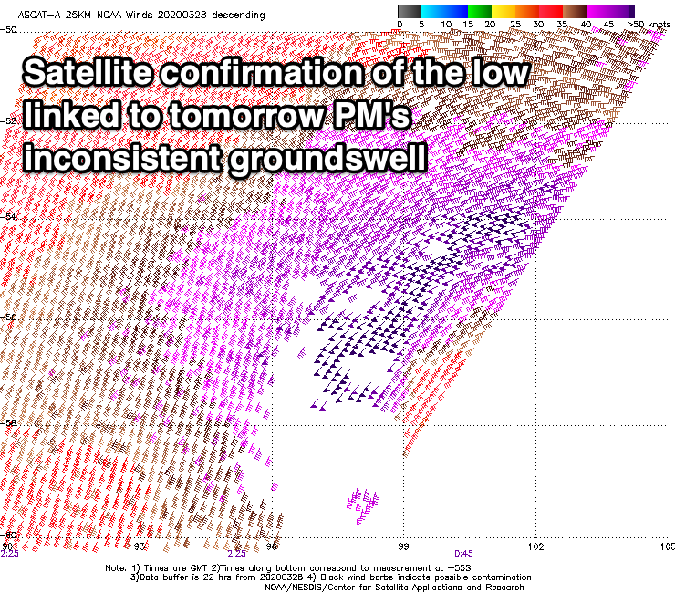
The South Coast should see a touch more action with sets to 2-3ft across Middleton, but of greater importance is the long-period SW groundswell due into the afternoon.
This was generated over the weekend by a significant polar low that formed east of Heard Island with a fetch of severe-gale to storm-force W/SW winds projected through our far south-western swell window.
The low has since weakened and produced the mid-latitude front linked to tomorrow's reinforcing W/SW swell, with the groundswell proper due to arrive mid-morning tomorrow and build to 4-5ft off Middleton by late afternoon.
Locally winds look great for both coasts tomorrow with a light variable tending offshore breeze on the Mid Coast, N/NW down South ahead of weak sea breezes.
As talked about last week, follow up frontal activity through the Southern Ocean will soften the easing trend through the rest of the week with a couple of good reinforcing swells on the cards for Wednesday afternoon and then Friday.
Wednesday's will be from the SW, generated by a good fetch of W'ly gales moving in south of WA this morning. Tomorrow afternoon's SW groundswell should ease back from the 4ft range off Middleton, not dropping below 3-4ft into the afternoon but then a touch smaller and to 3ft+ Thursday morning.
One final front on the tail of the entire progression tomorrow should keep 3ft sets hitting Middleton Friday morning, but then ease thereafter, smaller Saturday.
Coming back to the Mid Coast and Wednesday looks smaller and to 1-2ft, easing from 1-1.5ft on Thursday.
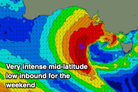 Conditions from Wednesday look good each morning with a NE breeze down South Wednesday, E/NE on the Mid ahead of fresh afternoon sea breezes, N/NE-NE on Thursday morning and then strengthening N/NW tending W/NW on Friday as a deep and powerful mid-latitude low moves in from the west.
This system looks quite significant with it deepening under the effects of a fast moving node of the Long Wave Trough later this week and subsequent upper cold pool.
The models are divergent on the positioning and strength of this system with GFS having it further north and slower, while EC has it further south and faster.
Either way we're looking at a cold, windy and stormy weekend of waves as the low moves across us, a good one to stay isolated and inside with no quality expected in the forecast swell. More on this dynamic system on Wednesday though.
Comments
The new swell.
Pity about the persistent fkn onshore all day was some great size on the mid with the tide yesterday