
Indonesia/Maldives forecast Nov 3

Indian Ocean Basin analysis by Craig Brokensha (issued Tuesday November 3rd)
This week through next (Nov 4 - 13)
The surf’s been small but a new mid-period S/SW swell is due to fill in later today, peaking tomorrow before easing into Thursday/Friday.
It was sourced from healthy but not overly strong polar frontal activity that fired up around the Heard Island region late last week, pushing east through the weekend.
This should provide 4-6ft sets on the exposed magnets, smaller across all other breaks.
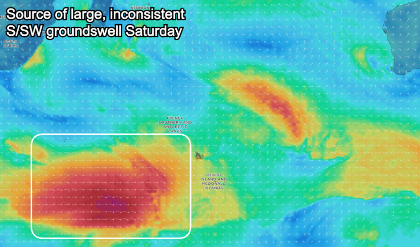
Now, later Friday/Saturday morning a new, background S/SW groundswell is due with a stronger pulse of energy due to peak through the day/afternoon Saturday.
The best pulse was produced by a stronger polar frontal progression that formed further away in our swell window, west of Heard Island over the weekend.
Fetches of W/SW gales with the odd stronger embedded surge should produce more size and power on Saturday to 5-6ft+ across exposed breaks through the middle of the day/afternoon, easing slowly into Sunday and further next week.
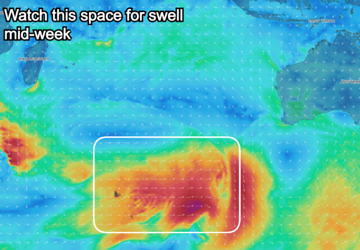
Longer term the models agree that some form of new mid-period S/SW swell will fill in Wednesday afternoon, peaking Thursday morning but the size and strength is still up for grabs.
It’ll be sourced from a healthy Southern Ocean frontal progression firing up north-east of the Heard Island region later this week, with GFS going for a more significant swell producer. More on this in the coming updates.
Slacker trades are due over the coming days, becoming more variable from Thursday (locally offshore) with afternoon sea breezes. This looks to be the start of the transition from dry season to wet season.
----------------------------------------------
Mentawais:
As discussed last week, only a small to moderate sized increase in mid-period S/SW swell is due over the coming days, mixed in with some small background S/SW groundswell Thursday and Friday morning.
Later in the day Friday and Saturday morning, the best pulse of S/SW groundswell is due, generated by the healthy frontal progression that fired up west of the Heard Island region.
This swell should peak to a good 5-6ft across exposed breaks Saturday morning, easing back thereafter, smaller into Sunday and early next week.
The outlook for mid-late week revolves around the divergent model strength of the frontal progression firing up north-east of the Heard Island region later week so we’ll have another look at this Thursday. Regardless there looks to be some fun new energy in the water.
Variable winds are due this period, freshening a touch out of the S/SE-SE at times across southern regions tomorrow and through the weekend.
----------------------------------------------
Maldives:
Moderate levels of slowly easing S/SE tending SE swell are due this week with a mix of long-range swells due to arrive into Thursday afternoon, best size wise Friday morning.
Thursday’s is background though decent energy with Friday’s pulse generated by the storm that fired up west of the Heard Island region over the weekend.
Both these swells are due to ease into the weekend with the swell bottoming out into Monday morning.
Into the afternoon and more so Tuesday background levels of small mid-period S/SW swell are on the cards, generated south and south-east of South Africa over the coming days.
Otherwise a weak persistent fetch of SE trades sitting south-southwest of the Indonesian region will produce a small background signal of SE trade-swell through next week.
Variable tending SE winds tomorrow are due to go variable tomorrow then weak W into Friday, persisting all weekend before freshening next week out of the W/NW-NW.
Eastern Indonesia:
Moderate sized, inconsistent mid-period S/SW swell for tomorrow to 4-6ft across exposed breaks, easing into the end of the week.
Inconsistent background S/SW groundswell for later Friday/Saturday morning with a stronger inconsistent SW pulse for Saturday afternoon, easing slowly Sunday. Sets peaking to 5-6ft+ across magnets.
Moderate sized mid-period S/SW swell for Wednesday afternoon/Thursday to 4-6ft.
Slacker trades are due over the coming days, becoming more variable from Thursday (locally offshore) with afternoon sea breezes.
Uluwatu 16-day Forecast Graph/WAMs
Western Indonesia/Mentawais/South Sumatra:
Small to moderate sized pulses of S/SW swell over the coming days.
Inconsistent, moderate sized S/SW groundswell for Friday ahead of a stronger pulse late in the day, peaking Saturday morning to 5-6ft across exposed breaks.
Moderate sized mid-period S/SW swell likely mid-late next week.
Variable winds are due this period, freshening a touch out of the S/SE-SE at times across southern regions tomorrow and through the weekend.
Mentawai 16-day Forecast Graph/WAMs
Maldives:
Moderate sized S/SE trade-swell easing slowly over the coming days while tending SE.
Easing sets from 4ft+ across the southern atolls tomorrow, smaller Male.
Small-mod sized S/SW mid-period swell for Thursday afternoon with a stronger pulse Friday to 4ft on the southern atolls, smaller Male.
Slow mix of swells all weekend.
Small SE swell next week to 2ft to occasionally 3ft across the southern atolls, smaller Male.
Small-mod sized S/SW mid-period swell for Tuesday/Wednesday to 3ft+ across the southern atolls, smaller Male.
Variable tending SE winds tomorrow are due to go variable tomorrow then weak W into Friday, persisting all weekend before freshening next week out of the W/NW-NW.
Latest news
Surfing On The Olympic Chopping Block
Laurie Towner's Balancing Act

Two Surf Spots, Both For Sale
Snapper Night Surfing Gets The Nod
Watch: Laurie Towner // Equilibrium

Pipe Masters 2026: What Everyone Needs

Watch: Kipp Caddy // Slab Sessions Ep.2

Watch: Every Excellent Wave // The Philippines Pro

Comments
Latest notes are live.
Thank you Craig, you’re worth more money , that Friday Saturday has put a smile on my dial . Been out of action last 4 days with a chest infection, bad cough & headache sore muscles but no fever, can’t remember the last time I felt no energy & run down . Nurse gave me some antibiotics & cough syrup yesterday so should be good in a few days . It’s only been waist to chest so not missing much.OTF if you’re over your ear infection then it could be worth coming down , LL in mornings & LR in afternoons
Guys I’ve been in the north Sipura region for the past 2 days and just now motoring in toward LR. Your wind speed and direction has been a bit off the mark and to be fair so has Windy.com. Is this due to localised squalls or is the synoptic forecast too unpredictable to rely on even a few days out?
Thanks Billy, in what way, do you have more detail?
Wind outlooks for Indo aren't as reliable as Australia thanks to the lack of resolution and topographic detail.
Thanks Craig. Sounds like forecast vagaries coupled with micro climates out here remain the wildcards as always. Maybe AGI will address the former down the track.
Also you talking about the forecasts or observations?