Mix of swells tomorrow, smaller into the start of the weekend

Hawaii North Shore forecast by Craig Brokensha (issued Tuesday 2nd February)
Best Days: Experienced surfers tomorrow and Wednesday morning, Monday ownards experienced surfers
This week and next (Feb 2 - 12)
 A new large NW groundswell is filling in nicely across the North Shore, and the waves are as good as they get at Pipeline for the Volcom Pro. Solid 8-10ft waves, with 12ft sets and offshore winds.
The swell should reach the 10-12ft range this afternoon, and with the 51101 buoy still holding size this afternoon, tomorrow morning should still provide 10ft+ sets before easing back through the day.
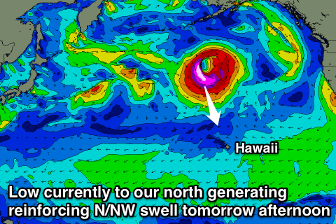
A large reinforcing N/NW groundswell is due into tomorrow afternoon, as a new very intense low pressure system raced in from the west, with it currently to our north, aiming a fetch of storm-force NW winds just on the edge of our swell window. This low is now tracking away to the north-east out of our swell window.
This should provide large 10-12ft+ sets from the north into the afternoon, before easing back from 8ft or so early Wednesday morning, much smaller into Thursday.
Fresh E/NE trades are due over the coming days, easing back into Thursday and then more variable Friday.
 Besides a small mid-period NW groundswell Thursday afternoon and Friday morning, the next significant swell is due Sunday ahead of a better pulse through Monday.
Sunday's increase will be related to a patchy and late forming storm to our north through the weekend, with a strengthening fetch of NW gales projected towards us, while stronger severe-gale to storm-force core winds will be just out of our swell window.
A mix of mid-period swell trains are due Sunday, ebbing and pulsing around 8ft to possibly 10ft, but with poor N/NE winds due to the close proximity of the swell producing front.
Of greater importance is a tight and strong front projecting a fetch of severe-gale NW winds down towards us over an active sea state on Sunday, producing a larger and more consistent N/NW groundswell for Monday. This swell should peak into the afternoon to a large 12-15ft+ across exposed breaks on the North Shore, easing back quickly through Tuesday.
Easing NE winds should create decent conditions as the swell peaks later in the day, with more variable winds for the rest of the week.
Longer term there's plenty more large groundswell pulses on the cards heading into the middle of February but we'll look at this in more detail on Thursday.