
El Nino Arrives, The Swell Not Yet

“There's definitely a lot of hype coming into this North Shore season,” says Hawaiian surfer Josh Moniz. “I feel like most of us don't really know what's coming. It's going to be a real unpredictable winter."
Every Northern Hemi winter is a time of anticipation for surfers around the North Pacific rim - Is their equipment ready? Are they physically prepared?
When El Niño is added to the equation, those questions just get more urgent.
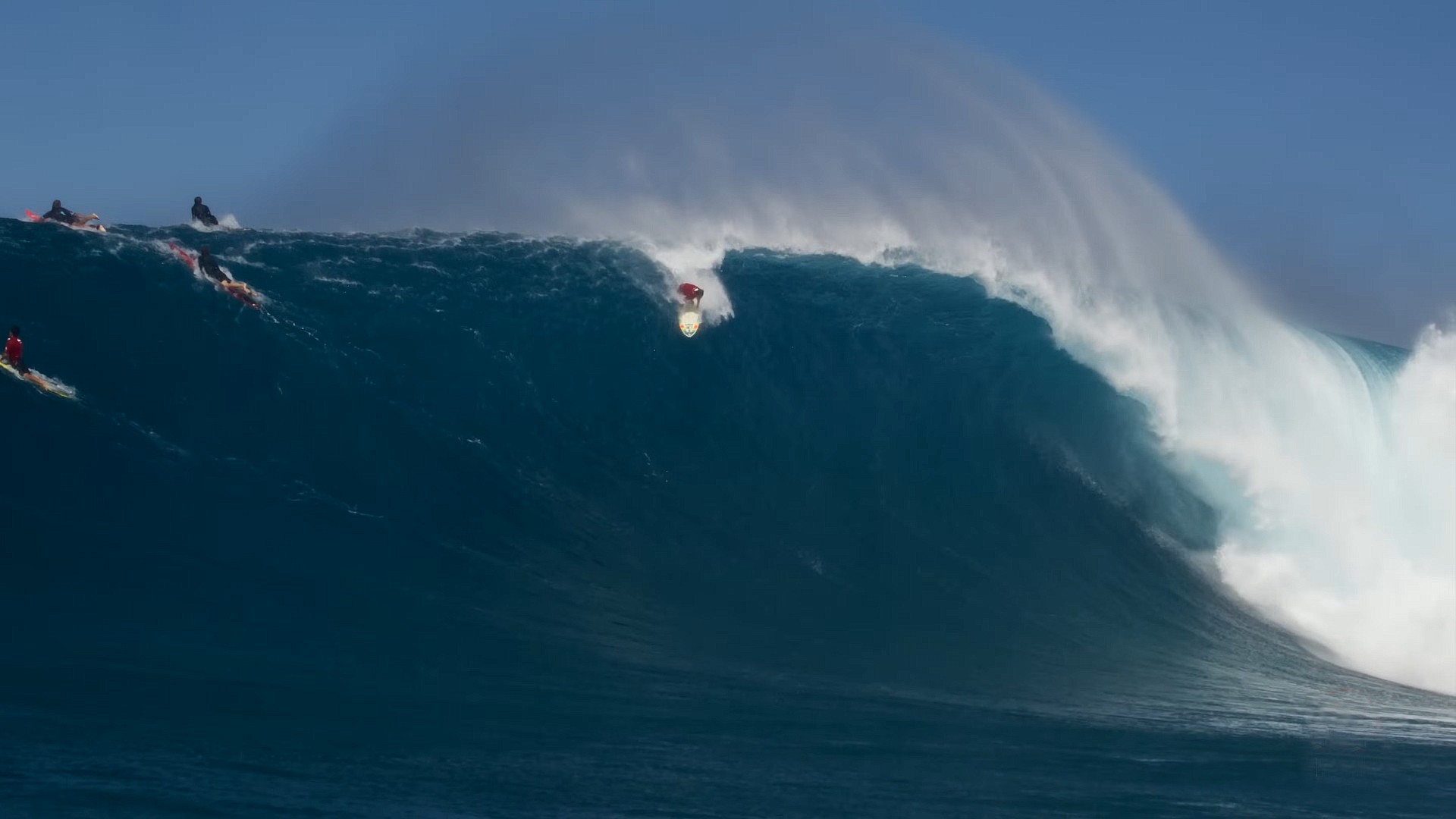
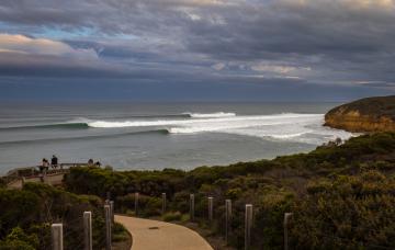
Question time is over: Jacob Turner swings late at Peahi in December, 2025 (Bonython)
Historically, El Niño events see the North Pacific storm track drop south - among other things - leading to a winter of big, consistent swell for Hawaii and California.
This year El Niño is unfolding, a record-breaking one by some measures, but to date it’s without swell. As of late October the North Shore of Oahu is yet to register a significant swell while Southern California is still running on Southern Hemi energy.
It’s still early in the season but shouldn't we have seen something by now?
Followers of Stormsurf’s Mark Sponsler will have noticed his growing agitation in recent weeks.
“El Niño is here and building!’ he proclaimed back on October 9th, "yet the tropics are on fire while the North Pacific sleeps.”
More recently he stated: “Looking at today’s wave model and jet stream charts it looks like a La Niña year. What gives?”
Even under neutral or La Niña conditions, the North Shore should have had something by now. The Sunset Beach Pro started today, it’ll be lucky to score an 8ft day anytime in the waiting period.
It’s not that the North Pacific is quiet. The storms are there, just in the wrong place. There’s been no southward shift in the jet towards Hawaii, with all the action focused up around the Aleutian Islands and Bering Sea.
Tucker Wooding works as a drone pilot in winter while plying Alaskan waters as a charter captain in summer. He knows the high latitudes well, and he’s been watching them closely.
“The storms have been crazy,” says Tucker of the systems in the Bering Sea and Gulf Of Alaska. “I’ve been tracking them non-stop and I’m just waiting for them to kind of drop lower and hit us in California and Hawaii.”
While twiddling his fingers in California his mind has wandered north. “Where I keep my boat there’s a lot of setups,” explains Tucker. “There’s been some crazy swells so some of the waves up there must’ve been really good.”
For anyone willing to go to the swell rather than wait for it, Tucker reckons the timing’s right.
“It’s really fickle and hard to get to, but this time of year is the best time to go. You’ve still got plenty of daylight and opportunity to score waves with the tides and swell windows.”
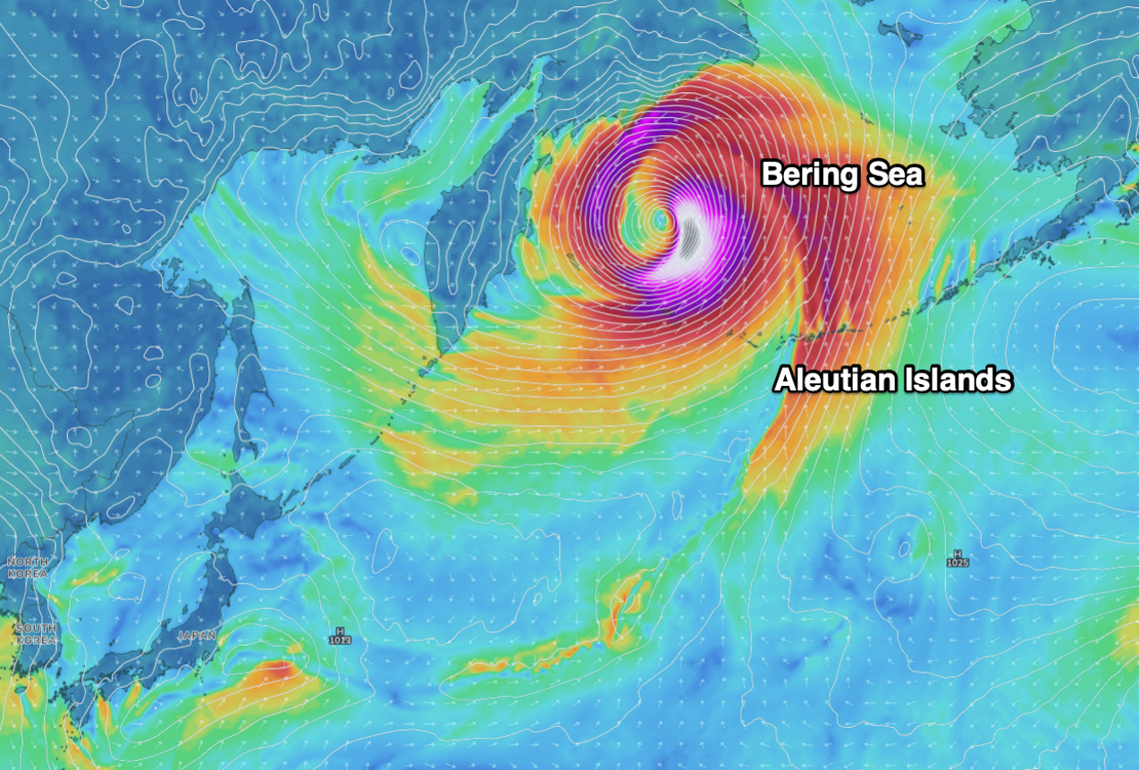
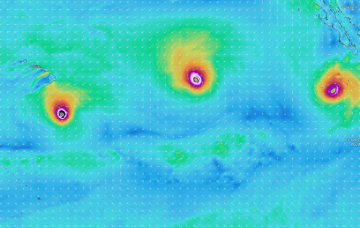
Exhibit A: Hurricane force low in the Bering Sea early this morning (GFS/Swellnet)
So, lots of swell up north, not much down south. What gives?
What follows is a working hypothesis.
In a typical strong El Niño, warm water through the eastern and central Pacific generates a large mass of rising air over those regions, which flows back to the west and sinks around northern Australia and Indonesia. This is the Walker circulation, and its shift during El Niño is what normally reshapes the jetstream and pulls the North Pacific storm track south.
This year the background has changed.
The El Niño itself is huge, with sea surface temperatures pushing 3.47°C above the average. However, the rest of the world’s oceans are running a fever too, and measured against that warmer background the El Niño is about 2.88°C above - still a significant anomaly but just below the November 2015 record of 3.08°C.
More telling is that the western Pacific hasn’t cooled as it usually does during El Niño. Warm pools surround most of Australia, with significant heating off southern NSW and east of Japan.
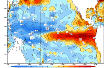
The image below tells the story. It’s the difference in sea surface temperature between this September and September 1997, which was another strong El Niño year.
The signal in the eastern and central Pacific isn’t much different, just a tad warmer, but the increase east of Japan and either side of Australia stands out.
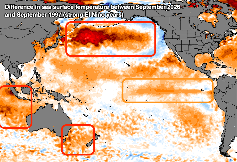
Evidence of a warming world. The difference between this year's strong El Niño (September) and 1997 (Climate Reanalyzer)
That warmth looks to be interfering with the Walker circulation, and with it the position of the North Pacific jet stream.
The second factor is the Pacific Decadal Oscillation (PDO). Think of it as a long-lived El Niño or La Niña-like setup across the Pacific, with warm and cool phases. It tracks sea surface temperature anomalies across the wider basin, with a horseshoe of warm water wrapping a cooler signal through the central and eastern Pacific.
The PDO has been negative since the start of 2020, reinforcing La Niña events. It’s weakened, but it’s still negative, and that works against any El Niño signal.
None of this means the season is a write-off. It’s still early, and the long-range seasonal models point to a southward shift in the storm track and an increase in swell activity towards the end of the year.
Till then, we wait with bated breath.
//CRAIG BROKENSHA and STU NETTLE
Comments
Nice write up Lord Craigos
The energy is still migrating through the machine
Watch & wait to see where & when it moves
Take it easy Ruck. There's enough hands on sausages around here already ;)
Craigos, you've done well to spot this and connect at least some dots. Can you tell me how those North Pac SST anomalies have eventuated and how they relate to this bogus "Super El Nino"? I can, as I've been intently watching the Sea of Okhotsk and the region's atmospherics as it relates to what has unfolded.
It's much like Caml's astute winter of high pressure observation it is accurate but hasn't been fully explained. It simply "is".
Maybe - just maybe - its by consistent/continual powerful setups like this pushing the warm water out into the Pacific. This is yesterday (Oct 26th) but its been happening continuously if you look back over the last 6 months+.
And these systems create huge troughs that extend east capturing/cradling and eventually depositing massive coherent air masses in the mid to east pacific that move south and scour out the equatorial zone / walker circulation resulting in reversing trade winds.
Friday Oct 23rd 2026... oh yes there's more. and more.
Did the powers at be finally swat ya with a giant oversized mozzie swatter
Or maybe they hit you with giant can of Fast Knockdown Aerosols
Stranger things have happened. In Barwon Heads for example
I've noticed that when you comment, whether it be here, on Mark Sponsler's YT channel, or on social media, you assume omniscience and we're all just catching up.
How about you spare us the sanctimony and state in simple language what your theory is?
Interesting, Offshoremozzie
Looking back over those six months, NOAA/JMA records show recurring North Pacific ridging, jet shifts and equatorial westerly anomalies. There are patterns and interactions worth discussing. Keen to hear how you’re connecting the dots while buzzing around Okhotsk, including what you mean by atmospheric adjustments
Out of interest mozzie have you noticed the plants or wildlife looking a bit worse for wear or behaving differently?
Island XXL!
I'd just come back from nor-cal this time of year in '97. By then there had already been 3 proper swells at Mav's, and a couple really nice W swells.
They'd be spewing it hasn't panned out as expected ..... So far!
Everything about this El Niño- except perhaps the effect on tropical East/Central Pacific has been a bit confounding.
Confounding to some. Thesis confirming to others....
And this is not to gloat but this event has been so absurd it's been very clear to see where and how the wheels have been BLOWN OFF!
I love your inferences, genuinely very intriguing, be great to have some detailed explanations though. Plenty of room below-the-line.
Spoke to an old bloke from Hawaii a few weeks back, he said most big El Nino years don't really start till the new year, then they go mad.
yep, I live near whistler BC Canada and agree, they don't get the NOV/DEC swell and neither do we get the storms for snow, we should get the biggest dumps of the year before xmass, instead its dry and a tough go till the new year, takes a good 6 week bite out of "winter" ,sux really
Surfers can be adaptable creatures of leisure, now is a climate for those to assist the less fortunate.
eg. Community adaptation to wildfires starts with individual decisions.
https://open.spotify.com/episode/5Hw0TPthAAfFdenPCD6qcR
Mid Spring on the Goldie + S/E Daily arvo-evening thunderstorms + Hail + Flooding + Black Outs
Free Tip! Reedy Creek copped a good pelting of Hail...equal to heaviest we had in last 2 decades.
Important...Not super Wild but > Slow warning then got heavier & lasted a real good while.
Started real casual but really got going for 10 mins ... so yeah! Easily a 1/20 year deal for us!
Ours here were large Grape Sized & Smoky Glazed...tasted Ok! Covered about half the ground.
Others got larger Perfect STAR Cluster Types
( Peas > 2.5cm Round > Avg Large Grapes (Ours) > 7cm Star Clusters > 7cm Golf > a few Tennis Balls)
Not going for record size hail but Largest widest swathe in one Super Cell all at once...Massive Blanketing!
Giant hailstones up to 7 centimetres in diameter (tennis ball size) tore across a wide swath of South East Queensland (SEQ) this afternoon, striking multiple corridors across the Ipswich region, Logan, and the Gold Coast hinterland
Gympie > Centre Goldie > Ipswich copped Unusually Large < > 500km wide blanketing of hail easy!
Just saying this would be considered rare...you'd have to check way back in news for this Mass event!
AI : A 500km square severe thunderstorms bringing hail to South East Queensland is an expected annual occurrence during peak storm season...All say Aye...hardly a big deal 'round these parts.
*Though a single continuous 500km swath of giant hail from an individual storm cell is extremely rare. For a single storm event to lay down a mesoscale footprint exceeding 500km it requires immense upper-tropospheric forcing.
Frequency : Highly unusual (tbb can't recall 1/20 years > try closer to 1/50 years)
And this early in the season makes it a rare beastie...An almighty ominous sign for summer...Gulp!
The Setup: For a single storm cell to drop hail continuously over hundreds of kilometers, it must evolve into a long-tracked supercell.
(Yeah & tbb checked the Sky & it was hardly menacing!) Actually stood out in it!
The Reality: While the Bureau of Meteorology classifies giant hail (greater than 5cm) as a significant threat that requires precise atmospheric conditions, climatologists note that the frequency of giant hail events in major Australian capital cities like Brisbane is increasing due to warmer, more unstable atmospheres.
When the weather in Florida gets cold, Hawaii gets big. It hasn't been cold in Florida yet, this season, and looks to stay at or above normal/average temperatures for a week or even more. When the overnight lows in Central Florida start dipping below 10 C, start looking for waves on the North Shore, and when the daytime highs in Central Florida dip below 10 C, maybe be thinking about waxing up your gun, or giving the jetski a tuneup. And now that I've opened up my big mouth about it, we get to sit back and see if it correlates again, this year.
I don't think Matt Bevan has any meteorological credentials but he does do some decent research on his topics. This one was quite interesting regarding the history of recording El Nino and the current super El Nino maybe not behaving like it should.
The surf media and the big wave guys are all very focussed on what El Nino means for Hawaii and California. I am much more intested in what it means over this side of the Pacific. Questions that I have: 1. What is the effect on trade wind belts north and south of the equator? This relates directly to production of ENE trade swells heading to PNG surf regions like New Ireleland. 2. What about winter storms crossing Japan and tracking SE across the Western Pacific? This relates to NNW - N - NE groundswells that light up everywhere from Micronesia (P Pass etc) to PNG, Solomons and the North Coast of Fiji and Samoa. There is a quote, "If its dumping it will be pumping!" (snow in japan then waves is PNG and Solomons).
Don't let Tucker be the only one having fun
https://www.alaskasurfguides.com/surfboat
only thing happening out here in NORCAL is a good old 8 to 10 sec northwest at 3 to 5ft killing every good south swell, short of 2 decent north swells and New Zealand mega 2 weeks spell this has been a big let down so far .
Very apt photo Stu. That Jacob Turner is the dark lord.
There's a high moving building this weekend to 1040 and forecasted twin highs next week in the Northern Pacific.
Peak El Nino end of November. Just fascinating.
Raining a lot lately in parts of WA, SA and beyond, its all coming across from NW WA from the big warm pool of water out there in the Indian Ocean. Can't complain though as the el nino drough has not even began.. fascinating turn of events / climate drivers!
The Northern Territory has had lots rain too , didn't mention above, when I should have!
Whole country, or a majority of it, is getting soaked.
Related to northern Hemi - earliest polar vortex collapse:
https://www.yahoo.com/news/weather-news/articles/earliest-polar-vortex-…
Viewer using Earth Nullschool and 10HPa over the north pole:
https://earth.nullschool.net/#current/wind/isobaric/10hPa/orthographic=…
Q for Craig or Ben: are the northern Hemi high altitude winds are changing from the calm summer pattern where there isn't a defined polar vortex right over the pole? Ergo, the article title isn't really correct as it's the Southern Hemi that has had the most recent winter polar vortex.
Next Q: Or do they mean a generation of a winter polar vortex (3 of them right now) is the earliest this has been generated on record?