
Typhoon Champi Steals The Crown

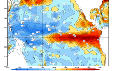
The eastern Pacific has hogged the cyclone headlines this year, and fair enough. An intense El Niño has driven the basin to a record for Accumulated Cyclone Energy. Three storms reached Category 5: Genevieve, Lowell and Polo, with the latter bottoming out at 892 hPa - the second-lowest central pressure ever recorded in the basin.
Meanwhile, on the other side of the dateline, the western Pacific has been quietly chugging away.
The typhoon season got going in January with the earliest named storm since 2019, and it had at least one named storm every month after.
Sinlaku became a super typhoon in April, a rare thing for that time of year. Bavi followed in July, hitting the Northern Marianas at Category 5 strength. Dolphin went the same way a few weeks later. Now there’s Champi, the fourth Category 5 in the west this year and the 30th named storm on the yearly count.
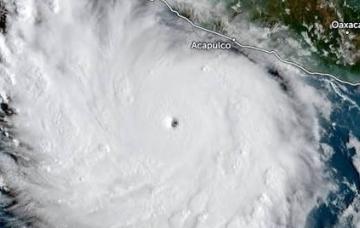
Champi formed as a depression on 11 October and was a typhoon within a week. On Sunday, it passed about 20 km off the southern tip of Guam, close enough to tear roofs off houses and flatten trees.
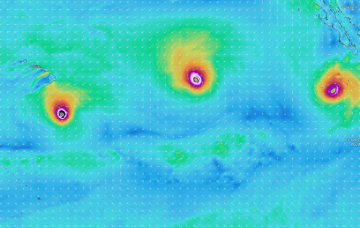
From there it moved into the Philippine Sea, where the water is running near 30°C and wind shear is low, and it kept deepening. Yesterday (Tuesday 20/10) its winds were clocking sustained one-minute speeds of 160 knots (296 km/h) with gusts to 195 knots (361 km/h).
That makes Champi the strongest storm on the planet this year by wind speed.
Meanwhile, its central pressure dropped to 895 hPa. Only Polo has gone deeper.
It’s also big. Gale-force winds extend more than 450 km from the centre in the northeast quadrant, and typhoon-force winds (equivalent to Cat 1) reach out around 150 km.
Today, the waves on Siargao Island - site of the upcoming Cloud 9 CT - are 8ft+ under moderate SW offshores. Further north the wave size is similar, however Champi's track will see a large jump in energy later today. Catanduanes is expecting waves approx. 15 ft with winds that suggest protected corners might be doable, while the Batanes archipelago in the far north sits at the extreme end in both wave size and wind strength.
Champi's most probable track has it passing over south-east Taiwan, near Taitung County, which is incidentally due to host a QS 6,000 next month.
Fortunately, Champi is moving into a less favourable environment and is forecast to weaken to Category 3 or 4 by Thursday and Friday. That’s still a dangerous storm, and it’s this weakened version that will reach land.
Notably, while most agencies have Champi making landfall on Taiwan, Taiwan’s own bureau holds it north of the island before it bends toward Zhejiang and Fujian in China.
Either way, the entire region: Philippines’ Batanes group, Japan’s Sakishima Islands and Taiwan’s east coast will get roughed up by waves and wind beginning tomorrow and lasting through till Sunday.

Comments
Batten down in the Batanes!
PS: Wonder if Harry will go for a second serve of Roast.
Whats the forecast for cloud 9 looking like Stu?
It's still too early to tell, mate. Very hard coast to give a forecast beyond five or so days. However, it's been pretty fertile for tropical activity the last few months, rarely going a week without something in their swell window. Plus both EC and GFS are showing early activity between Guam and Hawaii forming this weekend. If that develops it'll bode well for the contest.
Thats the track you want for Cloud9- ideally passing to the south of Guam.
Been one after the other now for weeks.
I don’t like the sound of that…
Ha.
I guess it'll make the water it passes over somewhat cooler for a bit. Trying to find balance.
Watched some footage the other day of the cyclone/ hurricane.
Looked too big with no real entry to the wave .
Each section was clamping on the sets .