Stratospheric warming event - forecasting the hype


Now this is going to get interesting!
Craig, what is the interaction between Stratospheric weather and that of the Troposphere?
Will we see weather patterns in the Troposphere become more meriodonal (excuse spelling if terrible) as we see in the Northern Hemi (think fires in Siberia, Snow in Morocco)?


What’s it done when it occurred recently ?
Will it be as catastrophic as Y2K bug ?


https://earth.nullschool.net/#current/wind/isobaric/10hPa/orthographic=-...
Follow at earth.nullschool, choose '10HPa' to see Stratospheric winds (you can see large anticyclone over Australia at present). I was reading an article that suggested the anticyclone has to get lower than 60S to be declared an event? Last was 2002?
Click on 'temp' to see the temperature at this level


So.....what effect will this potentially have on Australia?
Or on anything, anywhere?


Now from memory it was perhaps May 2016 when we last had a stratospheric anticyclone positioned over Australia of a decent size, wind and surf conditions here in Vixico were such that you had mostly clear skies, strong westerlies and it pumped for a month. Now we have had mainly similar in the winds and swell over this winter already, punctuated by a few bigger fronts and a couple of periods of warmth over several days when a high becomes dominant: we are at the end of the winter now and there will be a time when the vortex (/ies) dissipate and the southern hemi upper winds go into their tranquil summer pattern.
I've been screenshotting these winds for about 5 years now, the craziest stuff has been happening in the Northern Hemi so far. But there have been times when we develop more than the one vortex in the south in winter.
Craig if you want me to send through any screenshots, just ask.


"Yeah, we'll see big cold pools break off and track meridionally.
Apparently the South American Andes trigger everything when this warming travels down into the lower atmosphere over the coming weeks causing breaking waves. The mountains act as a barrier, breaking the flow and causing chaos.
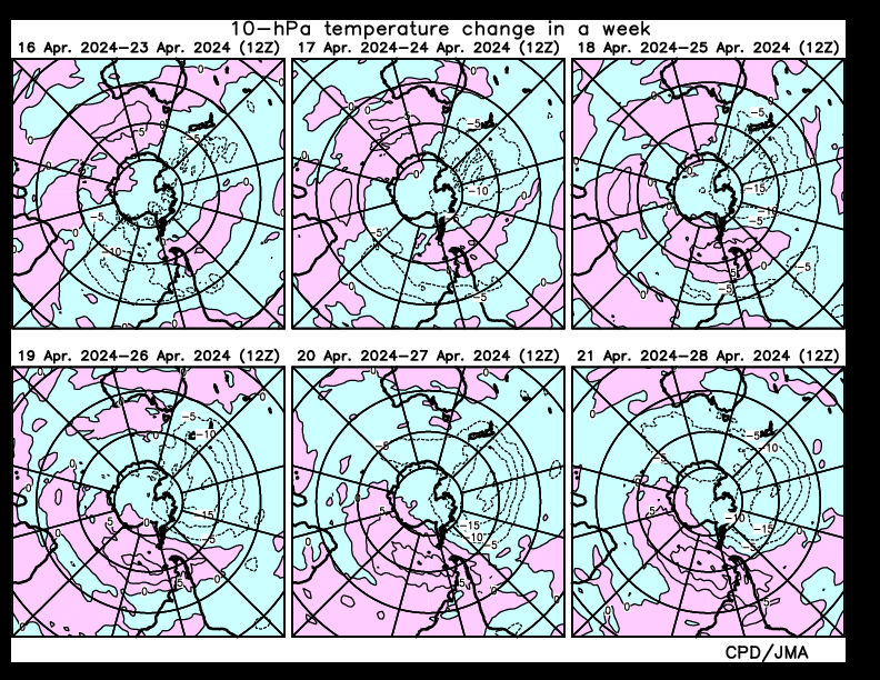
It should be noted changes of 25deg or more is labelled as a sudden warming event, and here, with 5deg contours we've jumped 35deg in a week!"
Thanks for that info, we are living in very crazy disturbed times. The causes are really the subject of another thread (that will be inevitably shut down) - but for now, just take an eye to the sky and every other way we have of measuring it. It's a privilege to be here now. Btw my lettuces are cranking in their little planting box, can't hurt to grow some of your own food in present times. Got some organic heirloom tomatoes and asparagus (long haul) seed yesterday too!
I'm off to see what spaceweather has been doing.


Start your thread , VJ.
Sounds interesting.
PS cheers Craig.


Researched this polar stratospheric weather couple of months ago, for a good start here's a primer from phys.org:
https://phys.org/news/2014-05-earth-magnetic-field-important-climate.html
I'm a bit busy with work right now, hopefully will get time to get into it tonight


Craig can you screenshot and post a stratospheric earth.nullschool pic of Aus and south pole for me, 10HPa, and temp (the winds will be on it already, you will see the vortex and anticyclone)
I don't know how to post them on SN


awesome. those rossby waves breaking in the stratosphere are so cool


Great video Craig.
Looking through the current space weather, we have had a coronal hole stream hit us and there's another inbound. These do not seem to be at extreme strengths, and there are no CMEs or solar flares influencing the earth.
https://www.swpc.noaa.gov/observations
A quick look above will show you current environment. Good as each chart you can click on explains what it is and how to read it.
Going further, I think I found something
https://ccmc.gsfc.nasa.gov/cgi-bin/display/RT_t.cgi
7th chart, ionospheric potential, current reading shows strong positive reading correlating area with area of the stratospheric heating. I have no idea if the chart is just showing a daily change, but clicking on the link and examining its component charts reveals a bit of a spike in the 7 day history of potential difference. I'm unfamiliar with this so any astrophysicists feel free to explain properly.
There's this, too:
https://www.sciencedirect.com/science/article/pii/S0169809599000150
paper suggesting using ionospheric potential as an alternate method of monitoring global temperature variation.


WTF? More importantly, who's gonna win Chopes?


Just look at that 'mountain torque' at work when you zoom in on nullschool over the Andes.
Wind differentials either side is phenomenal - and it's 20-odd kms above the Andes!


Agree Craig, I can't see any solar flares/CMEs causing it.


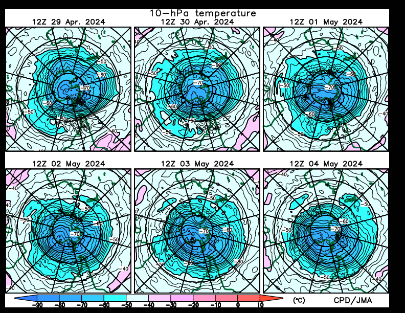
Temp up there is over 1 degree in the warming at present - according to nullschool.
In the centre of the main polar vortex next to it, it's -83 which gives an idea of the temp swing.


& large scale solar storm, first one in ages Aug 30,31, Sep 1,2. KP indexes >4
This at same time as Hurricane Dorian intensified to Cat 5.


Would you mind explaining that comment in laymen’s terms VJ?
You think it enhanced Dorian? and what are the KP indexes. Cheers, interested


Hi Shoredump, see my most recent comment in the Solar Flaring/CME's thread - it has links to a better explanation than I can give.
If you follow the source, I recommend the 'Climate Forcing' 1 hour vid to explain instantaneous forcing of the entire atmospheric column - something that has not been anticipated in Western science or added to any models.
As for KP Indexes, BOM have a great section on spaceweather, including an explanation of KP. You can find KPs from different locations online, eg Launceston and Hobart - useful when anticipating Aurora Australis. Basically: high KP usually from CME/flare or solar storm or coronal hole stream = lots of particles = brilliant lights in the sky. Enough of it, like Carrington event, and all our technology gets bricked (apart from 2H powered 60 series Landcruisers, you can hand-crank those).
https://www.sws.bom.gov.au/Educational/1/2/4
and here the KP page itself, with explanations:
http://www.sws.bom.gov.au/Aurora
A Tassie page, nice presentation:
http://www.aurora-service.net/aurora-forecast/
I have found a spot atop a high south facing cliff over the ocean on an island in southern Tassie, it's on the 'to do' list to score it on a clear night with the aurora going mental!


Craig, with that warming appearing to match the forecast models, what sort of timeframe before seeing some potential weather impacts?


Cheers Craig. The Abc has picked up on the Polar Vortex. Just when you think it couldn’t get drier, BOM is predicting it may result in even drier conditions.
https://mobile.abc.net.au/news/2019-09-06/rare-weather-event-over-antarc...


I might be missing something here but I've heard a few times on the radio from Someone at the BOM that this event will mean Warmer And Drier than average effects on SE australia. I'm expecting a continuation of winter. Which is more likely??


Yeh OK. My interpretation of zoning says Southeastern Australia is Vic, Tas and South Australia. Theirs is southern qld,NSW and Vic. So the pessimist in me says " Possibly weeks of shit winds and shocking surf in the West-facing southeast states,and Warm,dry WSWwinds for NSW, QLDetc. So I guess it means both.


Yeh OK. My interpretation of zoning says Southeastern Australia is Vic, Tas and South Australia. Theirs is southern qld,NSW and Vic. So the pessimist in me says " Possibly weeks of shit winds and shocking surf in the West-facing southeast states,and Warm,dry WSWwinds for NSW, QLDetc. So I guess it means both.


I think I get the gist of it. Was talking with some BOM crew last week and they were discussing it, so they must have some confidence in what they've found.
"Sudden stratospheric warming over Antarctica causes westerly winds south of Australia to track further north, a pattern meteorologists refer to as a 'negative SAM'."
So westerlies come further north (earlier this winter felt like the westerlies were dominating so I guess it's like the Groundhog coming out early and saying '8 more weeks of winter') - and inland NSW and QLD continue drought. We drove up through inland NSW earlier this year and the paddocks appeared bare, felt very sorry for them. For us on the southern coasts, more Westerlies, more swells that might not get fully into our coast, although the winds will be bent offshore. Sounds OK.
And more rain, why not, my front lawn is a quagmire.
In the last week it's felt like spring, today the grey skies and rain came over again (westerlies).
Craig, when you get a change in a season, do you often see more disturbance in the atmosphere? Recently there have been some very tall anvil tops around here, thick clouds going very high up, far more lightning thunder etc.


The snippy below is from this article https://theconversation.com/the-air-above-antarctica-is-suddenly-getting...
Who do you believe? ok, that's a rhetorical question.


I was hoping that there might have been a “beast from the east” type weather system being spun off from the pole creating large storm/ rain / swell rain event, but as V J said sounds more like a continuation of winter type weather. Surf wise for the Tasman i guess that will mean continued large SW swells with some refraction into the east coast?


Can't complain about that setup.
Nicest difference is the sunniness, and warmth while all this happening. Water is still cool though.


Hard to look at those charts and not think there might be some kind of relationship. But very difficult to prove at this early stage.


ben and crew, there is a relationship between everything. the proof is life=earth=one biosphere= part of our suns influence = one living organism on planet earth= variable= yet dependant on same stimuli= we are all in this together= can we change it= can the metaphysical recreate the physical????? is the maya something that can be changed through a common consciousness shift????? i say yes, what do u say?


It's gone pretty quiet since all the weather watchers collectively jizzed their strides about this. Any hindcasting points of relevance found, or did the airmasses bounce up and down too high to effect much on the ground?


Yeah, scroty we got no f-ing idea what's going on. So have fun, be thankful and don't take things too seriously.


So, let me tell you, by the end of the next three weeks you'll be so sick of the word stratospheric warming and the polar vortex (yes the real one, not some made up headline).
I've never looked into this part of the atmosphere and it's effect on the surface level patterns, but a mate Tyson got onto it 1-2 weeks ago and it now looks to occur.
Bascially the polar vortex sits over the South and North Poles, and is an area of low pressure in the upper atmosphere. This generally stays over the poles and rotates west to east as normal.
We're currently seeing a sudden warming of the stratosphere which is quite rare in the Southern Hemisphere, with only two occuring in the last two decades (across New Zealand).
What this warming does is disrupt the polar vortex, filtering down into the lower atmosphere, bringing bigger and colder cold outbreaks compared to what's normally seen.
Where this occurs is unsure and it'll take a couple of weeks for the event to take place, hence why I feel the media is going to run with this one and really milk it.
Watch this space!
Rare weather phenomenon possible