Onshore winds and strengthening swells, better next week

Western Australia Surf Forecast by Craig Brokensha (issued Wednesday 17th October)
Best Days: No good days until next week
Recap
A drop in swell and fairly lumpy average conditions across the South West yesterday morning, but with winds remaining light into the afternoon along with a large new long-period groundswell on the build, conditions improved with good waves across selected spots after lunch. Perth and Mandurah were around 2-3ft with good clean conditions ahead of sea breezes.
Today all coasts were great with easing but still good sized surf though make the most of it as we've got a poor run of onshore winds and swell ahead.
Today’s Forecaster Notes are brought to you by Rip Curl
This week and weekend (Oct 18 - 21)
An onshore change that's currently pushing in across the state is associated with a relatively weak but north tracking mid-latitude frontal system, with it due to push through proper tomorrow, bringing poor and strong W'ly tending SW winds through the day (developing later afternoon further north).
With this a mix of moderate sized mid-period swell mixed in with windswell is expected to build through the day to a stormy 3ft in Perth and Mandurah and an average 4-6ft or so across the South West.
We'll likely see the surf ease from a similar size through Friday with fresh onshore W/SW-SW winds keeping conditions poor across all locations.
A new longer-period SW groundswell should be seen Sunday, but ahead of this Saturday will be smaller and deteriorating with a strengthening W/NW wind and building W/NW windswell.
Sunday's groundswell will be produced by the earlier stages of the front generating the strengthening W/NW winds, with a pre-frontal fetch of W/NW gales moving south-west of us.
 It looks like our models are over-forecasting the size, with Margs likely to come in at 6ft to possibly 8ft, with 3ft sets in Mandurah and 2-3ft across Perth.
Winds will still be poor as another front pushes into us bringing strong W tending W/SW winds to all locations.
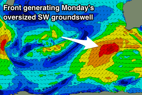
This front will be a broad polar system, moving on top an active sea state and projecting a fetch of SW gales up towards us through the weekend, generating an oversized SW groundswell for Monday.
Margs looks to build to the 10ft range, with 3-4ft sets in Mandurah and 3ft waves in Perth through the afternoon with a fresh but easing SW breeze that will more than likely be S/SE across Mandurah and Perth early morning.
Winds should swing offshore across all locations into Tuesday with large easing sets out of the SW before another approaching front swings winds onshore into the afternoon.
This front isn't expected to generate any real decent swell, but spoilt conditions, more on this Friday though.