Easing surf ahead of increased activity from Sunday

Western Australia Surf Forecast by Craig Brokensha (issued Wednesday 10th October)
Best Days: Thursday morning across the South West, Perth and Mandurah Monday morning, all locations Tuesday and Wednesday mornings
Recap
Super fun waves across the South West yesterday with strong but easing offshore winds and a slight bump in new swell, tiny to the north. Today our better W/SW groundswell has filled in with pumping sets in the 6ft range across the South West and 2ft in Mandurah, 1-2ft Perth.

Today’s Forecaster Notes are brought to you by Rip Curl
This week and next (Oct 11 - 19)
Today's good pulse of long-range W/SW groundswell should ease back through tomorrow, further Friday.
Conditions are now only looking clean tomorrow morning with a light E/SE offshore across the South West, and E/NE in Perth, swinging onshore into the afternoon as a small surface trough/low drifts east.
The South West should ease back from 4-5ft, 1-2ft in Mandurah and tiny in Perth, while Friday will see lingering onshore winds in the wake of the trough/low, W-W/SW tending W/NW across Margs and W/SW further north.
 Winds now look to go onshore a bit earlier in the forecast period than expected on Monday with a series of strong mid-latitude fronts expected to move in from the west from the weekend, under the influence of a strong node of the Long Wave Trough.
Firstly though we'll see a polar front generating a fetch of strong to gale-force W/SW winds, overridden by a mid-latitude front pushing on top the active sea state and into us Saturday evening and Sunday.
We'll see both swells from these storms arriving at the same time Sunday afternoon, with Saturday small and onshore with strengthening NW winds ahead of the mid-latitude front bringing strong to gale-force W/SW winds.
Sunday should see wave heights building rapidly to a stormy 8-10ft across the South West with strong to gale-force but easing W/SW winds, a stormy 3-4ft in Mandurah and 3ft+ in Perth.
The front will clear to the east Tuesday resulting in a drop in swell but lingering NW winds (E/NE in Perth and Mandurah) ahead of the next pulse of large W/SW groundswell.
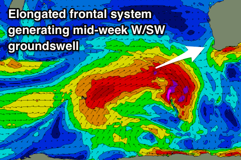
The secondary W/SW groundswell should be generated by a secondary elongated mid-latitude frontal system firing up north-east of Heard Island, projecting a fetch of gale to severe-gale W/SW winds towards us over the weekend.
The groundswell is due to build through Tuesday with sets to 8ft later in the day across the South West, 3ft in Mandurah and 2-3ft Perth, with possibly the odd bigger one in the mix across the South West Wednesday morning.
Winds at this stage look generally favourable and from the NE each morning Tuesday and Wednesday, W/NW into the afternoons. We'll have a closer look at this on Friday though.