Good swell incoming with good winds

Western Australia Surf Forecast by Craig Brokensha (issued Monday 8th October)
Best Days: Tuesday Margs, Wednesday all locations, Thursday morning all locations, Friday morning Margs
Recap
Bumpy conditions with a drop in swell across the South West on Saturday, much better and cleaner yesterday with the wind swinging more offshore along with similar amounts of size. Perth and Mandurah were clean though tiny.
The swell has eased back into this morning, best across the South West swell magnets.
Today’s Forecaster Notes are brought to you by Rip Curl
This week and weekend (Oct 9 - 14)
The coming few days are looking best for surf with offshore winds and a new mix of groundswells.
The first and smallest swell is due tomorrow, generated by a pre-frontal fetch of W/NW gales south-east of South Africa, ahead of a much better and broader fetch of post-frontal gale to severe-gale W/SW winds.
The pre-frontal fetch was short-lived and only expected to provide inconsistent 3-4ft+ sets on the South West swell magnets, tiny in Perth and Mandurah. Conditions will be great with a moderate to fresh E/SE offshore possibly tending variable but most likely giving into mid-late afternoon sea breezes.
The larger groundswell from the better fetch is due to fill in Wednesday with inconsistent but good sized 6ft sets due across the South West, 2ft in Mandurah and 1-2ft in Perth.
 Winds will be great again with E/NE offshore, tending variable again ahead of mid-late afternoon sea breezes, while as the swell eases on Thursday, a morning E/SE offshore will tend more SW as a surface trough drifts east, bringing the onshore change.
Friday morning should see winds swing back offshore across all locations as the swell continues to ease, tiny around Perth and Mandurah and best on the magnets across the South West with 3-4ft+ sets.
There's nothing significant on the cards for the weekend with small background levels of swell with deteriorating winds on Saturday, possibly lingering Sunday as a weak mid-latitude front moves through.
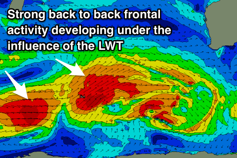
As touched on last update, longer term we're due to see a strong node of the Long Wave Trough developing to our west, and with this a series of strong polar and mid-latitude fronts are forecast to project up towards us, generating large pulses of W/SW groundswell from Tuesday next week, persisting into possible the next weekend.
Winds look to be initially good before going onshore as the fronts push across us. More on this Wednesday though.
Comments
Swell is looking good..