Clean easing surf tomorrow, slower there on

Western Australia Surf Forecast by Craig Brokensha (issued Wednesday 3rd October)
Best Days: Thursday across the South West, morning Perth and Mandurah, early Friday across the South West, swell magnets Sunday and Monday morning's across the South West, Tuesday and Wednesday mornings
Recap
Large clean pumping surf across the South West yesterday morning with the swell coming in a little above expectations with easing 6ft+ surf, 2ft in Mandurah and Perth.
The swell eased through the day with a low point seen early this morning though with offshore winds across all locations.
A large new long-period SW groundswell has since started to build across the South West and we should see magnets across the South West reach 8-10ft mid-late afternoon (it's already 6ft+), 3ft in Mandurah and 2ft+ in Perth late. Winds should hold out of the E/SE although strong, if not dipping ,ore SE across Margs at times like currently, but generally conditions should be good.


Today’s Forecaster Notes are brought to you by Rip Curl
This week and weekend (Oct 4 - 7)
This afternoon's large long-period SW groundswell was generated by a severe low forming south-west of us earlier this week, and satellite observations confirmed storm-force W/SW winds generated in our swell window.
This low has since moved off under the country and with it we'll see the swell peak this afternoon/evening across the state, easing back through tomorrow from 6ft+ across Margs, 2ft+ in Mandurah and 1-2ft in Perth.
Gusty E/SE winds are due across the South West, though a small low drifting south may see winds tend more E/NE across the northern end of the Cape into the afternoon, while Mandurah and Perth will see dawn E/NE winds, swinging anti-clockwise towards NW through the afternoon.
Friday will be smaller, but there's now a window of cleaner conditions due across the South West with a variable breeze ahead of a S/SE change, while Perth and Mandurah will be poor with fresh N/NW tending NW winds.
 Magnets across the South West are due to ease back from the 4ft range.
A new SW groundswell due later Friday and Saturday from pre-frontal W/NW gales isn't looking too favourable any more with a weaker storm generating less than favourably aimed winds through our swell window.
Instead we're looking at the South West coming in around 3-4ft most of the weekend, small to tiny to the north.
S/SE winds will persist Saturday, with magnets the go on Sunday with a better E/SE-SE offshore.
The swell will bottom out on Monday, with a small new SW groundswell for Tuesday ahead of a better long-period SW groundswell Wednesday.
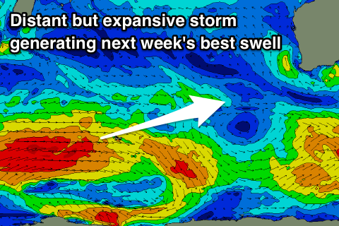
Tuesday morning's swell will be generated by pre-frontal W/NW gales ahead of a much better aligned and elongated fetch of gale to severe-gale W/SW winds, generating Wednesday's swell.
A small kick in size to 3-4ft is due Tuesday, with Wednesday's swell providing better 6ft sets across the South West, 2ft Mandurah and 1-2ft Perth.
Conditions look great each morning with local offshore E'ly winds ahead of afternoon sea breezes.
Longer term it looks like winds will swing onshore later next week with some possible new swell, but more on this Friday.
Comments
Windy but pumping!
Proper pumping..