Average short term period ahead; clean XL surf due later next week

West Australian Surf Forecast by Ben Matson (issued Saturday 16th June)
Best Days: Perth/Mandurah: Early Sun, then Tues/Wed - though no major size. Thurs/Fri looking at strong swells with light winds. Margaret River: Tues: small waves inside protected bays and points. Thurs/Fri: possible XL swell with light winds.
Recap: Strong though inconsistent swells across the South West, smaller throughout Perth and Mandurah.
Today’s Forecaster Notes are brought to you by Rip Curl

Solid sets at Margs this morning - check the bloke in the lip!
This weekend and next week (Jun 16 onwards)
Want to receive an email when these Forecaster Notes are updated? Then log in here and update your preferences.
Note: Today’s Forecaster Notes will be brief, as Craig is away on annual leave. Also, these Forecaster Notes will be updated Tuesdays, Thursdays and Saturdays for the next few weeks.
There’s no shortage of surf for the next few days, but local conditions look very average. An approaching front will strengthen northerly winds Sunday, before they swing gusty W’ly in the early hours of Monday morning. A secondary front overnight Monday will maintain onshores through into Tuesday morning but they’ll weaken throughout the day.
A third, stronger front and low but tracking at more southerly latitudes will clip the coast on Wednesday, re-establishing the westerly flow though mainly affecting the Margaret River region.
Sunday morning may see a small window of early NE winds across Perth and possibly Mandurah, but with only small residual swells on offer there won’t be a lot to get excited about. Today's inconsisent groundswel will slowly ease in size throughout the day.
A large swell increase will trail Monday’s frontal passage, building wave heights into the afternoon, though it’ll be a poor mix of distant groundswell and short range windswell. Tuesday is expected to have small options at protected bays and coves in the Margs region as the swell eases, but it's not worth working around.
Perth and Mandurah should have lumpy workable options Tuesday as winds ease, but it won’t be fantastic and we won't see a lot of size across these regions either. North from Mandurah, Wednesday is unlikely to see much influence from the passing front (to the south), so expect clean conditions, but only small leftover swells once again.
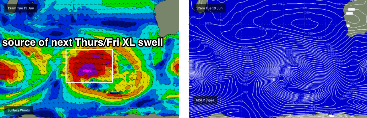
While all of this is going on, a much more significant system will have been tracking eastwards through the Southern Indian Ocean (see below), generating a large groundswell that’s due to arrive Thursday.
Fortunately, the associated front is expected to weaken considerably by the time the swell makes landfall, so we’re looking at locally light winds. Model guidance has the Margaret River region pushing 7m at 17 seconds (!) late Thursday which suggests easy 15ft+ sets across exposed regions (considerably bigger at offshore bombies), and with plenty of west in the swell direction we should see some great waves, quite strong too, across Perth and Mandurah coasts (between 3ft and 5ft).
As such, it’ll be well worth pencilling in Thursday and Friday next week for some quality surf. More on this in Tuesday’s update.
Comments
Lovely corduroy at Yallingup a short time ago.

Strong lines at Margs too.
